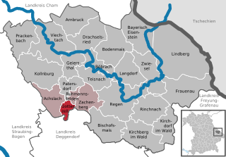
Румансфельден (Ruhmannsfelden, Ruhmannsfelden)

 Hiking in Румансфельден
Ruhmannsfelden, a picturesque town in Bavaria, Germany, offers an array of scenic hiking opportunities for outdoor enthusiasts. Nestled in the heart of the Bavarian Forest, the region is characterized by its beautiful landscapes, lush forests, and rolling hills. Here’s what you can expect when hiking in and around Ruhmannsfelden:
Trails and Routes
-
Local Trails: There are numerous well-marked trails that range in difficulty for hikers of all skill levels. Some popular routes include:
- The Bavarian Forest National Park Trails: Nearby, this national park offers extensive hiking routes that showcase stunning views and diverse wildlife. Trails vary from easy walks to challenging hikes.
- Circular Trails: Look for circular routes around Ruhmannsfelden that provide a great way to experience the local flora and fauna.
-
Scenic Views: Many trails lead to viewpoints where you can enjoy panoramic vistas of the surrounding forested landscape and valleys.
Nature and Wildlife
- The Bavarian Forest is home to diverse plant and animal species, including deer, wild boar, and various birds. Hiking here gives you the chance to observe this wildlife in their natural habitat.
- The region’s rich biodiversity is complemented by a variety of ecosystems, including dense woodlands and clear streams.
Essentials for Hiking
- Equipment: Ensure you have sturdy hiking boots, weather-appropriate clothing, a map or GPS, plenty of water, and snacks.
- Weather: Check the weather forecast before heading out, as conditions can change quickly, especially in mountainous areas.
Hiking Tips
- Be Prepared: Familiarize yourself with the trail conditions and difficulty levels. It’s advisable to start with easier hikes and gradually progress to more challenging ones as you gain experience.
- Trail Etiquette: Follow local guidelines regarding trail use, and always stay on marked paths to protect the environment.
Local Attractions
- While hiking, consider taking the time to explore local landmarks or attractions in Ruhmannsfelden, such as cultural sites or traditional Bavarian villages.
Overall, hiking in Ruhmannsfelden provides a fantastic way to connect with nature, enjoy the tranquility of the Bavarian Forest, and experience the region's natural beauty. Whether you’re a novice hiker or an experienced trekker, there’s something for everyone to enjoy.
- Страна:

- Почтовый код: 94239
- Телефонный код: 09929
- Код автомобильного номера: REG
- Координаты: 48° 59' 0" N, 12° 59' 0" E


- GPS треки (wikiloc): [Ссылка]
- Высота над уровнем моря: 536 м m
- Площадь: 5.8 кв.км
- Население: 1972
- Веб сайт: https://www.ruhmannsfelden.de/
- Википедия русская: wiki(ru)
- Википедия английская: wiki(en)
- Википедия национальная: wiki(de)
- Хранилище Wikidata: Wikidata: Q489100
- Катеория в википедии: [Ссылка]
- код Freebase: [/m/02q78xv]
- код GeoNames: Альт: [2843223]
- код VIAF: Альт: [238120439]
- ID отношения в OpenStreetMap: [959164]
- код GND: Альт: [4549563-4]
- код Historical Gazetteer: [RUHDE1JN68LX]
- Bavarikon ID: [ODB_A00001604]
- идентификатор муниципалитетов в Германии: 09276142
Граничит с регионами:


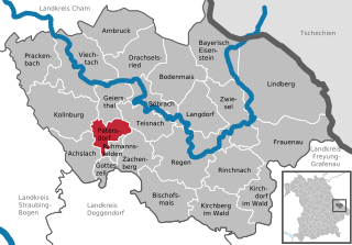
Цахенберг
Hiking in Цахенберг
Zachenberg, located in Bavaria, Germany, is a beautiful destination for hiking enthusiasts. Surrounded by picturesque landscapes, lush forests, and rolling hills, it's an excellent place to explore nature and enjoy outdoor activities....
- Страна:
- Почтовый код: 94239
- Телефонный код: 09929
- Код автомобильного номера: REG
- Координаты: 48° 58' 0" N, 13° 0' 0" E
- GPS треки (wikiloc): [Ссылка]
- Высота над уровнем моря: 602 м m
- Площадь: 27.29 кв.км
- Население: 2046
- Веб сайт: [Ссылка]

Готтесцелль
Hiking in Готтесцелль
Gotteszell, located in the Bavarian Forest of Germany, is a charming destination for hiking enthusiasts. The area is characterized by its lush forests, rolling hills, and stunning panoramic views, making it ideal for outdoor activities. Here’s a brief overview of what to expect while hiking in Gotteszell:...
- Страна:
- Почтовый код: 94239
- Телефонный код: 09929
- Код автомобильного номера: REG
- Координаты: 48° 58' 0" N, 12° 58' 0" E
- GPS треки (wikiloc): [Ссылка]
- Высота над уровнем моря: 510 м m
- Площадь: 9.22 кв.км
- Население: 1167
- Веб сайт: [Ссылка]

Патерсдорф
Hiking in Патерсдорф
Patersdorf is a picturesque village located in Bavaria, Germany, known for its beautiful natural landscapes, making it an excellent location for hiking enthusiasts. Nestled near the edge of the Bavarian Forest National Park, Patersdorf offers a variety of trails that cater to different skill levels, from leisurely walks to more challenging hikes....
- Страна:
- Почтовый код: 94265
- Телефонный код: 09923
- Код автомобильного номера: REG
- Координаты: 49° 1' 0" N, 12° 59' 0" E
- GPS треки (wikiloc): [Ссылка]
- Высота над уровнем моря: 503 м m
- Площадь: 17.04 кв.км
- Население: 1699
- Веб сайт: [Ссылка]