Saint-Colomban-des-Villards (Saint-Colomban-des-Villards)

- коммуна во Франции
 Hiking in Saint-Colomban-des-Villards
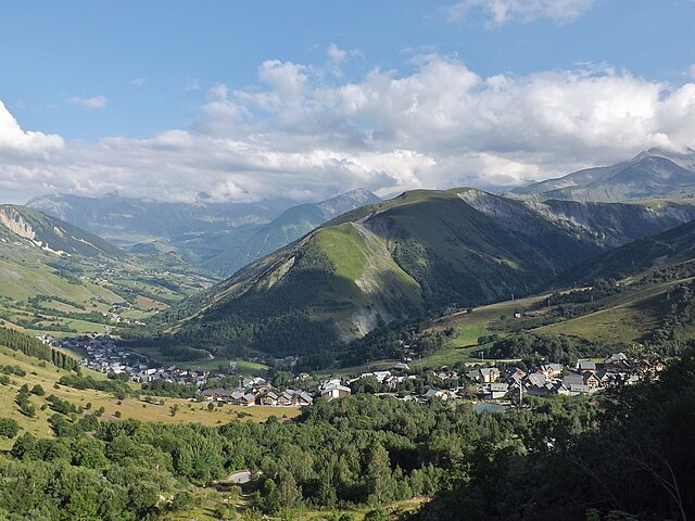
Saint-Colomban-des-Villards is a charming commune in the Savoie region of the French Alps, known for its stunning landscapes and diverse hiking opportunities. The area offers a mix of trails that cater to different skill levels, from leisurely walks to challenging hikes.
Hiking Opportunities:
-
Scenic Trails: The region boasts beautiful alpine trails that provide breathtaking views of the surrounding mountains, including the Grand Pic de la Lauzière. Many routes take you through lush forests, alpine meadows, and past crystal-clear streams.
-
Family-Friendly Hikes: There are several easy, family-friendly hikes that allow you to enjoy the outdoors without strenuous effort. These trails are perfect for families with children or those looking for a more relaxed hiking experience.
-
Challenging Routes: For more experienced hikers, there are plenty of trails that require a higher level of fitness and navigation skills. Some paths lead to mountain peaks and offer panoramic views, while others take you along more rugged terrain.
-
Wildlife and Nature: While hiking, you may encounter a variety of wildlife native to the region, including chamois and marmots. Spring and summer are particularly vibrant, with wildflowers dotting the landscape.
-
Historical Sites: Many trails also have the opportunity to discover cultural and historical sites, such as old chalets, churches, or remnants of ancient villages.
Preparation Tips:
- Best Time to Visit: The ideal hiking seasons are typically late spring to early autumn. Summer offers the most stable weather conditions, while the fall provides stunning autumn colors.
- Equipment: Wear good hiking boots, carry a map or GPS device, and bring sufficient water and snacks. Consider trekking poles for more challenging hikes.
- Weather Awareness: Mountain weather can change rapidly. Always check the forecast and be prepared to adjust your plans accordingly.
- Guided Tours: If you're unfamiliar with the area, consider joining a guided hike. Local guides can provide insight into the landscape and safety tips.
Getting There:
Saint-Colomban-des-Villards is accessible by car and is a great base for exploring the surrounding regions of the French Alps. Public transportation options may also be available, but checking local schedules in advance is advisable.
Overall, hiking in Saint-Colomban-des-Villards offers an unforgettable experience for outdoor enthusiasts, with stunning views and diverse trails that showcase the natural beauty of the French Alps. Enjoy your adventure!
- Страна:

- Почтовый код: 73130
- Координаты: 45° 17' 39" N, 6° 13' 36" E


- GPS треки (wikiloc): [Ссылка]
- Высота над уровнем моря: 1204 м m
- Площадь: 81.12 кв.км
- Население: 173
- Википедия английская: wiki(en)
- Википедия национальная: wiki(fr)
- Хранилище Wikidata: Wikidata: Q747072
- Катеория в википедии: [Ссылка]
- код Freebase: [/m/03npfj0]
- код GeoNames: Альт: [6442866]
- номер SIREN: [217302306]
- код BNF: [152741613]
- код тезауруса PACTOLS: [pcrtNHUk6fPMga]
- код муниципалитета INSEE: 73230
Граничит с регионами:


Ла-Ферьер
Hiking in Ла-Ферьер
La Ferrière, located in the Isère department in France, is a charming village nestled in the French Alps. It offers a variety of hiking opportunities for both beginners and experienced hikers. The region is known for its stunning landscapes, featuring picturesque valleys, rugged mountain terrain, and lush forests....
- Страна:
- Почтовый код: 38580
- Координаты: 45° 19' 11" N, 6° 5' 14" E
- GPS треки (wikiloc): [Ссылка]
- Площадь: 54.33 кв.км
- Население: 231
- Веб сайт: [Ссылка]


Пенсо
- коммуна во Франции
Hiking in Пенсо
Pinsot is a charming village located in the Isère department in the Auvergne-Rhône-Alpes region of France. This area offers stunning natural landscapes, making it a delightful destination for hiking enthusiasts. Here are some key points to consider if you’re thinking about hiking in Pinsot:...
- Страна:
- Почтовый код: 38580
- Координаты: 45° 21' 25" N, 6° 6' 0" E
- GPS треки (wikiloc): [Ссылка]
- Площадь: 24.27 кв.км
- Население: 178
- Веб сайт: [Ссылка]


Saint-Alban-des-Villards
- коммуна во Франции
Hiking in Saint-Alban-des-Villards
Saint-Alban-des-Villards is a charming village located in the French Alps, specifically in the Savoie department of the Auvergne-Rhône-Alpes region. Hiking in this area offers stunning views, diverse landscapes, and a variety of trails suitable for different skill levels. Here are some highlights and tips for hiking in and around Saint-Alban-des-Villards:...
- Страна:
- Почтовый код: 73130
- Координаты: 45° 18' 33" N, 6° 14' 57" E
- GPS треки (wikiloc): [Ссылка]
- Площадь: 24.02 кв.км
- Население: 103

Saint-Sorlin-d'Arves
- коммуна во Франции
Hiking in Saint-Sorlin-d'Arves
Saint-Sorlin-d'Arves is a beautiful alpine village located in the Savoie region of the French Alps. It is particularly known for its stunning landscapes, diverse wildlife, and a range of hiking trails that cater to various skill levels. Here’s a general overview of what you can expect when hiking in the area:...
- Страна:
- Почтовый код: 73530
- Координаты: 45° 13' 16" N, 6° 14' 5" E
- GPS треки (wikiloc): [Ссылка]
- Площадь: 39 кв.км
- Население: 339
- Веб сайт: [Ссылка]

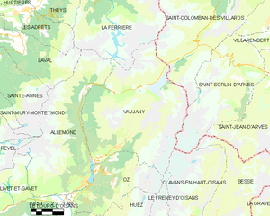
Вожани
- коммуна во Франции
Hiking in Вожани
Vaujany is a charming alpine village located in the French Alps, within the Oisans region, and is part of the larger Alpe d'Huez Grand Domaine Ski area. It's not only a great skiing destination but also an excellent location for hiking, especially during the warmer months when the snow melts and the trails become accessible....
- Страна:
- Почтовый код: 38114
- Координаты: 45° 9' 27" N, 6° 4' 36" E
- GPS треки (wikiloc): [Ссылка]
- Площадь: 64.54 кв.км
- Население: 307
- Веб сайт: [Ссылка]


Фонкуверт-ля-Туссюир
- коммуна во Франции
Hiking in Фонкуверт-ля-Туссюир
Fontcouverte-la-Toussuire is a picturesque village located in the Savoie region of the French Alps, offering a variety of hiking opportunities for outdoor enthusiasts. Whether you’re a beginner or an advanced hiker, the area provides trails that cater to different skill levels, along with stunning mountain scenery, alpine flora, and the chance to spot local wildlife....
- Страна:
- Почтовый код: 73300
- Координаты: 45° 14' 47" N, 6° 18' 9" E
- GPS треки (wikiloc): [Ссылка]
- Площадь: 21.52 кв.км
- Население: 534
- Веб сайт: [Ссылка]