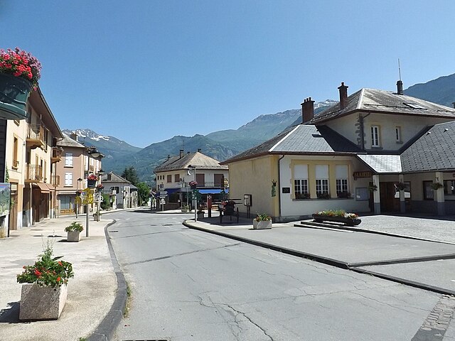
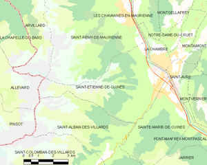
Saint-Alban-des-Villards (Saint-Alban-des-Villards)

- коммуна во Франции
 Hiking in Saint-Alban-des-Villards
Saint-Alban-des-Villards is a charming village located in the French Alps, specifically in the Savoie department of the Auvergne-Rhône-Alpes region. Hiking in this area offers stunning views, diverse landscapes, and a variety of trails suitable for different skill levels. Here are some highlights and tips for hiking in and around Saint-Alban-des-Villards:
Trails and Routes
-
Alpine Trails: The region features numerous alpine trails that allow hikers to explore the breathtaking mountain scenery, including lush meadows, forests, and rocky terrain.
-
Local Landmarks: Many hiking routes take you past historical sites and natural wonders, such as old chapels, waterfalls, and panoramic viewpoints.
-
Difficulty Levels: There are trails suitable for all levels, from easy walks to more challenging hikes that may require more experience and appropriate gear.
-
Short and Long Hikes: You can find both short half-day hikes as well as longer multi-day treks that connect with larger trail networks in the region.
Best Hiking Practices
-
Seasonal Considerations: Summer is the prime hiking season, but early autumn can also provide beautiful vistas, as the foliage changes color. Late spring may still have snow on higher trails, so check conditions before heading out.
-
Safety: Always let someone know your hiking plans, especially if heading out into more remote areas. Bring a map, compass, or GPS, and consider downloading trail apps for offline access.
-
Equipment: Good hiking boots, weather-appropriate clothing, and enough water and snacks are essential. Don’t forget sun protection and a first aid kit.
-
Wildlife and Environment: Be aware of local wildlife and respect their habitats. Leave no trace—pack out what you pack in.
Local Attractions
Don't forget to explore the local culture and enjoy some traditional Savoie cuisine after your hikes. You might also find opportunities for other outdoor activities, such as mountain biking or paragliding, depending on the season.
Conclusion
Hiking in Saint-Alban-des-Villards allows you to experience the natural beauty of the French Alps. Whether you're looking for a leisurely stroll or a vigorous hike, this region provides ample opportunities for outdoor enthusiasts. Plan ahead, stay prepared, and enjoy your adventure in this stunning part of France!
- Страна:

- Почтовый код: 73130
- Координаты: 45° 18' 33" N, 6° 14' 57" E


- GPS треки (wikiloc): [Ссылка]
- Площадь: 24.02 кв.км
- Население: 103
- Википедия английская: wiki(en)
- Википедия национальная: wiki(fr)
- Хранилище Wikidata: Wikidata: Q1158002
- Катеория в википедии: [Ссылка]
- код Freebase: [/m/03npffz]
- код GeoNames: Альт: [6442860]
- номер SIREN: [217302215]
- код BNF: [152741524]
- код муниципалитета INSEE: 73221
Граничит с регионами:


Пенсо
- коммуна во Франции
Hiking in Пенсо
Pinsot is a charming village located in the Isère department in the Auvergne-Rhône-Alpes region of France. This area offers stunning natural landscapes, making it a delightful destination for hiking enthusiasts. Here are some key points to consider if you’re thinking about hiking in Pinsot:...
- Страна:
- Почтовый код: 38580
- Координаты: 45° 21' 25" N, 6° 6' 0" E
- GPS треки (wikiloc): [Ссылка]
- Площадь: 24.27 кв.км
- Население: 178
- Веб сайт: [Ссылка]
Saint-Étienne-de-Cuines
- коммуна во Франции
Hiking in Saint-Étienne-de-Cuines
Saint-Étienne-de-Cuines, located in the Savoie region of the French Alps, offers beautiful hiking opportunities amidst stunning mountain scenery. The area is characterized by picturesque landscapes, including forests, alpine meadows, and views of the surrounding peaks....
- Страна:
- Почтовый код: 73130
- Координаты: 45° 20' 32" N, 6° 17' 30" E
- GPS треки (wikiloc): [Ссылка]
- Площадь: 20.5 кв.км
- Население: 1190

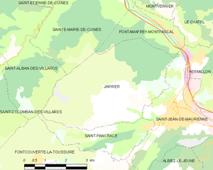
Jarrier
- коммуна во Франции
Hiking in Jarrier
Jarrier is a picturesque village located in the Savoie region of the French Alps, nestled at an altitude of around 1,500 meters. It's an excellent base for hiking enthusiasts, offering stunning views, diverse trails, and a chance to experience the natural beauty of the Alps....
- Страна:
- Почтовый код: 73300
- Координаты: 45° 16' 49" N, 6° 19' 0" E
- GPS треки (wikiloc): [Ссылка]
- Площадь: 17.79 кв.км
- Население: 497
- Веб сайт: [Ссылка]


Аллевар
- коммуна во Франции
Hiking in Аллевар
Allevard is a charming town located in the Auvergne-Rhône-Alpes region of France, nestled in the Belledonne mountain range. It's an excellent destination for hikers due to its diverse landscapes, ranging from forests and rivers to rocky peaks....
- Страна:
- Почтовый код: 38580
- Координаты: 45° 23' 37" N, 6° 4' 27" E
- GPS треки (wikiloc): [Ссылка]
- Площадь: 25.63 кв.км
- Население: 4124
- Веб сайт: [Ссылка]


Фонкуверт-ля-Туссюир
- коммуна во Франции
Hiking in Фонкуверт-ля-Туссюир
Fontcouverte-la-Toussuire is a picturesque village located in the Savoie region of the French Alps, offering a variety of hiking opportunities for outdoor enthusiasts. Whether you’re a beginner or an advanced hiker, the area provides trails that cater to different skill levels, along with stunning mountain scenery, alpine flora, and the chance to spot local wildlife....
- Страна:
- Почтовый код: 73300
- Координаты: 45° 14' 47" N, 6° 18' 9" E
- GPS треки (wikiloc): [Ссылка]
- Площадь: 21.52 кв.км
- Население: 534
- Веб сайт: [Ссылка]
Saint-Pancrace, Savoie
Hiking in Saint-Pancrace, Savoie
Saint-Pancrace, located in the Savoie region of the French Alps, offers a variety of hiking experiences that are suitable for a wide range of skill levels. The breathtaking scenery, characterized by alpine meadows, dense forests, and stunning mountain views, make it an attractive destination for outdoor enthusiasts. Here’s what you need to know about hiking in this area:...
- Страна:
- Почтовый код: 73300
- Координаты: 45° 16' 11" N, 6° 19' 32" E
- GPS треки (wikiloc): [Ссылка]
- Площадь: 5.59 кв.км
- Население: 295


Saint-Colomban-des-Villards
- коммуна во Франции
Hiking in Saint-Colomban-des-Villards
Saint-Colomban-des-Villards is a charming commune in the Savoie region of the French Alps, known for its stunning landscapes and diverse hiking opportunities. The area offers a mix of trails that cater to different skill levels, from leisurely walks to challenging hikes....
- Страна:
- Почтовый код: 73130
- Координаты: 45° 17' 39" N, 6° 13' 36" E
- GPS треки (wikiloc): [Ссылка]
- Высота над уровнем моря: 1204 м m
- Площадь: 81.12 кв.км
- Население: 173

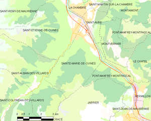
Sainte-Marie-de-Cuines
- коммуна во Франции
Hiking in Sainte-Marie-de-Cuines
Sainte-Marie-de-Cuines is a beautiful destination for hiking enthusiasts, nestled in the Auvergne-Rhône-Alpes region of France, specifically in Savoie. The area offers breathtaking landscapes, from rolling hills to the majestic alpine terrain, making it ideal for various hiking levels. Here are some highlights and tips for hiking in this region:...
- Страна:
- Почтовый код: 73130
- Координаты: 45° 20' 24" N, 6° 18' 6" E
- GPS треки (wikiloc): [Ссылка]
- Площадь: 14.95 кв.км
- Население: 812
- Веб сайт: [Ссылка]