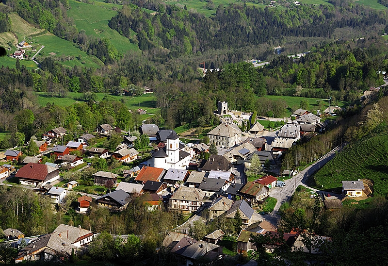
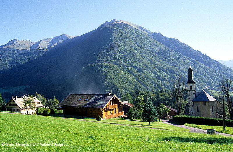
Saint-Jean-d'Aulps (Saint-Jean-d'Aulps)

- коммуна во Франции
 Hiking in Saint-Jean-d'Aulps
Saint-Jean-d'Aulps is a beautiful mountain resort located in the Rhône-Alpes region of France, within the wider Portes du Soleil area. It’s an excellent destination for hiking enthusiasts, offering a range of trails and stunning alpine scenery.
Hiking Trails
-
Le Roc d'Enfer: This hike offers spectacular views and is suitable for those with a moderate fitness level. The trail ascends to the Roc d'Enfer peak, providing breathtaking panoramas of the surrounding peaks and valleys.
-
The Vallée d’Aulps: This area features several well-marked routes that take you through picturesque landscapes of meadows, forests, and traditional alpine farms. The trails vary in difficulty, accommodating both beginners and experienced hikers.
-
Les Lindarets: Located close by, this area is famous for its charming goat village. The hiking trails here connect to other routes in the Portes du Soleil area, allowing for extended day hikes or multi-day treks.
-
Chalet de la Coutettaz: A popular hike that leads you to a traditional alpine chalet. It’s perfect for those looking to enjoy a meal or rest amidst nature, and it's accessible for families as well.
Seasonal Hiking
Hiking in Saint-Jean-d'Aulps is not limited to summer. In late spring and early fall, the landscapes are particularly vibrant. During winter, while snow-covered trails can transform into ski routes, some lower-altitude paths remain accessible for snowshoeing.
What to Expect
- Scenic Views: Expect to see stunning vistas, including mountains, alpine lakes, and wildflower-filled meadows.
- Wildlife: Keep an eye out for local wildlife, including deer, marmots, and various bird species.
- Cultural Heritage: The region has rich history and culture, so you may encounter traditional chalets and local farms along the trails.
Preparation Tips
- Gear: Ensure you have proper hiking boots, weather-appropriate clothing, and plenty of water.
- Maps and Guides: It’s advisable to bring a map or download trail apps. Local tourist offices may offer guides and recommendations.
- Acclimatization: If you're not used to high altitudes, take your time to acclimatize.
Local Amenities
Saint-Jean-d'Aulps provides various accommodations, restaurants, and shops. After a day of hiking, you can enjoy local cuisine, including specialties like fondue and raclette.
Whether you are looking for a relaxing day in nature or an adventurous hike with stunning alpine views, Saint-Jean-d'Aulps offers plenty of options for all skill levels. Enjoy your hiking experience in this picturesque part of the French Alps!
- Страна:

- Почтовый код: 74430
- Координаты: 46° 14' 5" N, 6° 39' 20" E


- GPS треки (wikiloc): [Ссылка]
- Площадь: 40.19 кв.км
- Население: 1241
- Веб сайт: http://www.saintjeandaulps.com
- Википедия английская: wiki(en)
- Википедия национальная: wiki(fr)
- Хранилище Wikidata: Wikidata: Q929287
- Катеория в википедии: [Ссылка]
- код Freebase: [/m/027ngdk]
- номер SIREN: [217402387]
- код BNF: [15274493j]
- код VIAF: Альт: [238804510]
- код муниципалитета INSEE: 74238
Граничит с регионами:


Abondance, Haute-Savoie
- коммуна во Франции
Hiking in Abondance, Haute-Savoie
Abondance, located in the Haute-Savoie region of the French Alps, is a beautiful destination for hiking enthusiasts. This charming village is well-known for its stunning mountain landscapes, lush valleys, and rich cultural heritage....
- Страна:
- Почтовый код: 74360
- Координаты: 46° 16' 44" N, 6° 43' 19" E
- GPS треки (wikiloc): [Ссылка]
- Площадь: 58.84 кв.км
- Население: 1377

Ле-Бьо
- коммуна во Франции
Hiking in Ле-Бьо
Le Biot is a charming village located in the Haute-Savoie region of France, nestled in the French Alps. It's a great destination for hikers due to its stunning natural scenery and variety of trails that cater to different skill levels. Here are some key points to consider when hiking in Le Biot:...
- Страна:
- Почтовый код: 74430
- Координаты: 46° 15' 46" N, 6° 37' 57" E
- GPS треки (wikiloc): [Ссылка]
- Площадь: 13.18 кв.км
- Население: 576
- Веб сайт: [Ссылка]

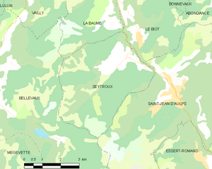
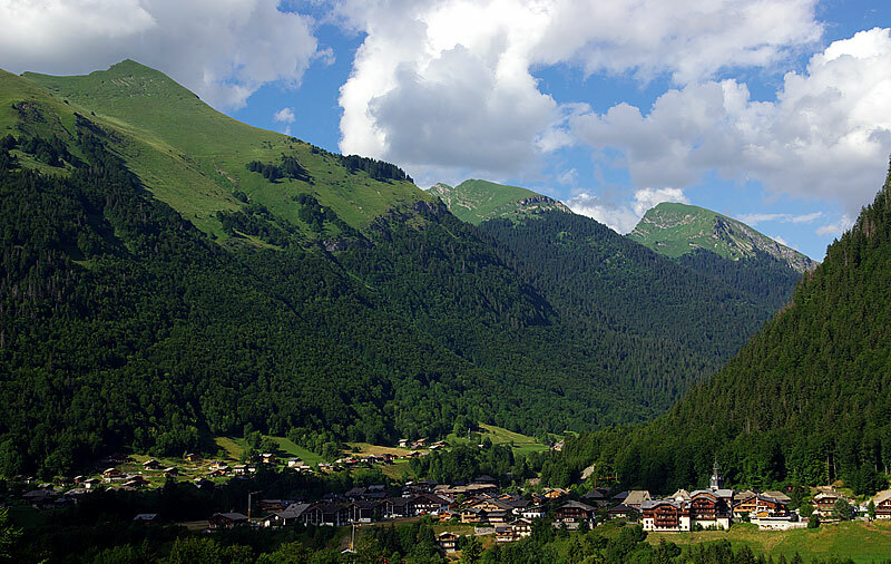
Seytroux
- коммуна во Франции
Hiking in Seytroux
Seytroux is a charming village located in the Auvergne-Rhône-Alpes region of France, specifically in the Haute-Savoie department. It is situated in the heart of the French Alps, which makes it a fantastic destination for hiking enthusiasts....
- Страна:
- Почтовый код: 74430
- Координаты: 46° 14' 58" N, 6° 37' 2" E
- GPS треки (wikiloc): [Ссылка]
- Площадь: 18.44 кв.км
- Население: 487
- Веб сайт: [Ссылка]


Bellevaux
- коммуна во Франции
Hiking in Bellevaux
Bellevaux is a charming village located in the French Alps, known for its stunning mountainous landscapes, lush forests, and beautiful trails, making it a fantastic destination for hiking enthusiasts. Here are some highlights and tips for hiking in the Bellevaux area:...
- Страна:
- Почтовый код: 74470
- Координаты: 46° 15' 25" N, 6° 31' 52" E
- GPS треки (wikiloc): [Ссылка]
- Площадь: 48.97 кв.км
- Население: 1282
- Веб сайт: [Ссылка]


La Côte-d'Arbroz
- коммуна во Франции
Hiking in La Côte-d'Arbroz
La Côte-d'Arbroz is a charming commune located in the Haute-Savoie region of the French Alps. Known for its stunning landscapes and proximity to the Portes du Soleil ski area, it also offers fantastic hiking opportunities, particularly in the summer months when the snow melts and the meadows bloom....
- Страна:
- Почтовый код: 74110
- Координаты: 46° 11' 16" N, 6° 40' 5" E
- GPS треки (wikiloc): [Ссылка]
- Площадь: 12.24 кв.км
- Население: 323
- Веб сайт: [Ссылка]

Essert-Romand
- коммуна во Франции
Hiking in Essert-Romand
Essert-Romand is a picturesque village located in the French Alps, near the popular resort town of Morzine. It offers stunning views, lush landscapes, and a variety of hiking trails suitable for different levels of hikers....
- Страна:
- Почтовый код: 74110
- Координаты: 46° 12' 6" N, 6° 40' 16" E
- GPS треки (wikiloc): [Ссылка]
- Площадь: 6.78 кв.км
- Население: 509
- Веб сайт: [Ссылка]

Montriond
- коммуна во Франции
Hiking in Montriond
Montriond, located in the French Alps near Morzine, is a beautiful destination for hiking enthusiasts. The area offers a range of trails with stunning views of the surrounding mountains, lush valleys, and crystal-clear lakes. Here are some key points about hiking in Montriond:...
- Страна:
- Почтовый код: 74110
- Координаты: 46° 11' 50" N, 6° 41' 39" E
- GPS треки (wikiloc): [Ссылка]
- Площадь: 24.71 кв.км
- Население: 902
- Веб сайт: [Ссылка]