Сен-Жанне (Saint-Jeannet, Saint-Jeannet)
- коммуна в департаменте Приморские Альпы, регион Прованс — Альпы — Лазурный Берег, Франция
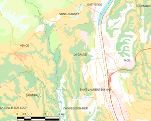
 Hiking in Сен-Жанне
Saint-Jeannet, located in the Alpes-Maritimes region of France, is a charming village that offers a variety of excellent hiking opportunities. Nestled in the foothills of the French Alps, it provides stunning views, diverse terrain, and a rich natural environment that attracts outdoor enthusiasts.
Key Hiking Trails:
-
Le Mont Chevalier: This is one of the most popular hikes in the area, offering panoramic views of the surrounding landscape. The trail can be moderately challenging, taking you through beautiful forests and rocky paths before reaching the summit.
-
Les Gorges du Loup: A bit further from Saint-Jeannet, this trail takes you through the Gorges du Loup, characterized by stunning cliffs and waterfalls. It's an excellent spot for both hiking and photography.
-
Saint-Jeannet to the Baous: This trail connects Saint-Jeannet to the nearby Baous mountain range, which has several peaks. The hike offers diverse scenery, including limestone cliffs and Mediterranean vegetation.
-
Pic de l'Ours: This hike provides a more strenuous option for those looking for a challenge. The trail leads you to higher elevations with rewarding views of the Côte d'Azur and the Mediterranean Sea.
Considerations:
-
Difficulty Levels: Hikes around Saint-Jeannet vary in difficulty from easy to challenging. Be sure to assess your fitness level before attempting longer or steeper hikes.
-
Weather: The weather can change rapidly in the mountains, so be prepared with proper gear, including waterproof clothing and sturdy hiking boots.
-
Wildlife and Flora: Keep an eye out for the diverse wildlife and unique plant species native to the region. Spring and early summer are particularly beautiful due to blooming wildflowers.
-
Local Guides: If you're unfamiliar with the area or hiking in general, consider hiring a local guide. They can provide insights into the region's natural history and ensure you stay safe on the trails.
Saint-Jeannet serves as a wonderful base for exploring the natural beauty of the Alpes-Maritimes while enjoying various hiking experiences suitable for all levels. Don't forget to take some time to relax and enjoy the local cuisine and charming architecture of the village!
- Страна:

- Почтовый код: 06640
- Координаты: 43° 44' 47" N, 7° 8' 36" E


- GPS треки (wikiloc): [Ссылка]
- Площадь: 14.58 кв.км
- Население: 4071
- Википедия русская: wiki(ru)
- Википедия английская: wiki(en)
- Википедия национальная: wiki(fr)
- Хранилище Wikidata: Wikidata: Q473663
- Катеория в википедии: [Ссылка]
- код Freebase: [/m/03m4z79]
- код Freebase: [/m/03m4z79]
- код GeoNames: Альт: [6618144]
- код GeoNames: Альт: [6618144]
- номер SIREN: [210601225]
- номер SIREN: [210601225]
- идентификатор местоположения ArchINFORM: [7596]
- идентификатор местоположения ArchINFORM: [7596]
- место в MusicBrainz: [cae98cfc-8239-472e-833a-84eecb0efdfb]
- место в MusicBrainz: [cae98cfc-8239-472e-833a-84eecb0efdfb]
- код муниципалитета INSEE: 06122
- код муниципалитета INSEE: 06122
Граничит с регионами:


Ванс
- коммуна в департаменте Приморские Альпы, регион Прованс — Альпы — Лазурный Берег, Франция
Hiking in Ванс
Vence, located in the Provence-Alpes-Côte d'Azur region of France, offers a fantastic blend of coastal and mountainous hiking experiences. Here are some highlights and tips for hiking in and around Vence:...
- Страна:
- Почтовый код: 06140
- Координаты: 43° 43' 21" N, 7° 6' 43" E
- GPS треки (wikiloc): [Ссылка]
- Площадь: 39.23 кв.км
- Население: 18393
- Веб сайт: [Ссылка]


Ницца
- коммуна в департаменте Приморские Альпы, регион Прованс — Альпы — Лазурный Берег, Франция
- Страна:
- Почтовый код: 06000
- Телефонный код: 493
- Координаты: 43° 42' 7" N, 7° 16' 6" E
- GPS треки (wikiloc): [Ссылка]
- Высота над уровнем моря: 10 м m
- Площадь: 71.92 кв.км
- Население: 342522
- Веб сайт: [Ссылка]

Ла-Год
- коммуна в департаменте Приморские Альпы, регион Прованс — Альпы — Лазурный Берег, Франция
Hiking in Ла-Год
La Gaude is a charming village located in the Alpes-Maritimes department in the Provence-Alpes-Côte d'Azur region of France. Nestled in the hills near the French Riviera, it offers beautiful landscapes, picturesque views, and a range of hiking opportunities for outdoor enthusiasts....
- Страна:
- Почтовый код: 06610
- Координаты: 43° 43' 19" N, 7° 9' 11" E
- GPS треки (wikiloc): [Ссылка]
- Высота над уровнем моря: 236 м m
- Площадь: 13.1 кв.км
- Население: 6415
- Веб сайт: [Ссылка]


Гатьер
- коммуна в департаменте Приморские Альпы, регион Прованс — Альпы — Лазурный Берег, Франция
Hiking in Гатьер
Gattières is a charming village located in the Alpes-Maritimes department in the Provence-Alpes-Côte d'Azur region of France, not far from Nice. The area surrounding Gattières offers a range of hiking opportunities that showcase the stunning landscapes of the French Riviera and the picturesque foothills of the Alps....
- Страна:
- Почтовый код: 06510
- Координаты: 43° 45' 34" N, 7° 10' 33" E
- GPS треки (wikiloc): [Ссылка]
- Площадь: 10.03 кв.км
- Население: 4111
- Веб сайт: [Ссылка]


Безодён-лез-Альп
- коммуна в департаменте Приморские Альпы, регион Прованс — Альпы — Лазурный Берег, Франция
Hiking in Безодён-лез-Альп
Bézaudun-les-Alpes is a charming commune located in the Alpes-Maritimes department in southeastern France. The area is known for its stunning natural landscapes, historical architecture, and a variety of hiking opportunities that cater to different experience levels. Here are some highlights and tips for hiking in and around Bézaudun-les-Alpes:...
- Страна:
- Почтовый код: 06510
- Координаты: 43° 48' 27" N, 7° 5' 46" E
- GPS треки (wikiloc): [Ссылка]
- Площадь: 21.44 кв.км
- Население: 243
- Веб сайт: [Ссылка]