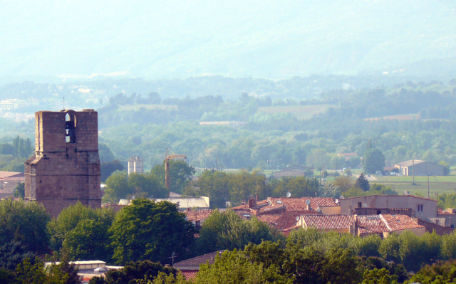
Нан-ле-Пен (Nans-les-Pins, Nans-les-Pins)

- коммуна во Франции
 Hiking in Нан-ле-Пен
Nans-les-Pins is a charming village located in the Var department in the Provence-Alpes-Côte d'Azur region of France. It's surrounded by beautiful landscapes, making it a great destination for hiking enthusiasts. Here are some highlights of hiking in and around Nans-les-Pins:
Trails and Routes
-
Les Gorges du Destel: This trail takes you through striking gorges with stunning rock formations and diverse flora and fauna. The views are breathtaking, particularly in the spring when wildflowers are in bloom.
-
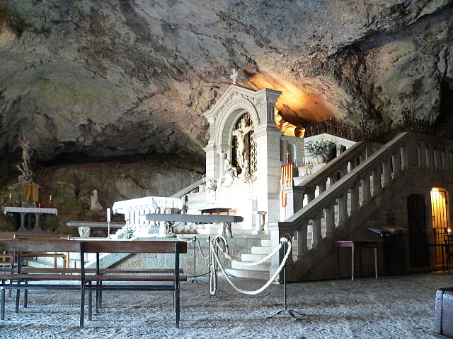
La Sainte-Baume Mountain Range: Not far from Nans-les-Pins, the Sainte-Baume Mountain offers a network of trails. The area is rich in history and legend, being linked to Mary Magdalene. The trails here range from easy to moderate, catering to different skill levels.
-
Circuit des Lavandes: This hike is perfect in the summer when the lavender fields are in full bloom. The trail offers picturesque views of the vibrant lavender fields and the surrounding landscape.
Natural Beauty
-
Mediterranean Flora and Fauna: The region is known for its aromatic herbs, oak forests, and diverse wildlife. Keep an eye out for local wildlife such as deer, birds, and various insects.
-
Panoramic Views: Many of the trails provide stunning vistas of the nearby hills, forests, and even glimpses of the Mediterranean Sea on clear days.
Tips for Hiking in Nans-les-Pins
-
Prepare for Varying Terrain: While many trails are well-marked, the terrain can vary significantly. Some trails may include rocky paths or steep ascents, so sturdy hiking boots are recommended.
-
Stay Hydrated: Especially in the warmer months, carry plenty of water as some trails can be exposed to the sun for long stretches.
-
Wildlife Awareness: Be mindful of local wildlife. It's general etiquette to respect their habitat and maintain a safe distance.
-
Season Considerations: Spring and early autumn are typically the best times for hiking in this region, offering comfortable temperatures and vibrant scenery, though summer can be hot and dry.
Accessibility
Nans-les-Pins is accessible by car, and several trails can be reached with a short drive from the village center. Public transportation options may be limited, so plan accordingly.
Local Amenities
The village has several amenities, including cafés and restaurants, where you can enjoy some local cuisine after a day of hiking. There are also shops where you can purchase local products, such as honey and lavender-based products.
In summary, Nans-les-Pins offers a blend of picturesque trails, beautiful nature, and rich history, making it an ideal spot for hiking enthusiasts looking to explore the natural beauty of Provence.
- Страна:

- Почтовый код: 83860
- Координаты: 43° 22' 14" N, 5° 46' 56" E


- GPS треки (wikiloc): [Ссылка]
- Площадь: 47.99 кв.км
- Население: 4276
- Веб сайт: http://www.mairie-nanslespins.fr
- Википедия русская: wiki(ru)
- Википедия английская: wiki(en)
- Википедия национальная: wiki(fr)
- Хранилище Wikidata: Wikidata: Q579138
- Катеория в википедии: [Ссылка]
- код Freebase: [/m/03w9krg]
- код GeoNames: Альт: [2990987]
- номер SIREN: [218300879]
- код BNF: [15277914h]
- код тезауруса PACTOLS: [pcrtIIUhQUlG8S]
- WOEID: [12667169]
- код TGN: [1034616]
- код муниципалитета INSEE: 83087
Граничит с регионами:

План-д’Опс-Сент-Бом
- коммуна во Франции
Hiking in План-д’Опс-Сент-Бом
Plan-d'Aups-Sainte-Baume is a beautiful destination for hiking enthusiasts, located in the Var department of the Provence-Alpes-Côte d'Azur region of southeastern France. Nestled at the foot of the Sainte-Baume mountain range, this area offers a range of trails that vary in difficulty and scenery....
- Страна:
- Почтовый код: 83640
- Координаты: 43° 19' 48" N, 5° 43' 3" E
- GPS треки (wikiloc): [Ссылка]
- Высота над уровнем моря: 700 м m
- Площадь: 24.91 кв.км
- Население: 2067


Ружье
- коммуна во Франции
Hiking in Ружье
Rougiers is a small commune located in the Var department in the Provence-Alpes-Côte d'Azur region of southeastern France. It is surrounded by beautiful natural landscapes, making it an excellent spot for hiking enthusiasts. Here's a guide to hiking in the Rougiers area:...
- Страна:
- Почтовый код: 83170
- Координаты: 43° 23' 33" N, 5° 51' 4" E
- GPS треки (wikiloc): [Ссылка]
- Площадь: 20.53 кв.км
- Население: 1623

Тре
- коммуна во Франции
Hiking in Тре
Trets is a charming town located in the Provence-Alpes-Côte d'Azur region of France, and it offers access to some beautiful hiking opportunities. The surrounding landscape features rolling hills, vineyards, and stunning views of the Sainte-Victoire Mountain, making it an appealing destination for outdoor enthusiasts....
- Страна:
- Почтовый код: 13530
- Координаты: 43° 26' 49" N, 5° 41' 9" E
- GPS треки (wikiloc): [Ссылка]
- Площадь: 70.31 кв.км
- Население: 10963
- Веб сайт: [Ссылка]


Пурсьё
- коммуна во Франции
Hiking in Пурсьё
Pourcieux is a charming village located in the Provence-Alpes-Côte d'Azur region of France. It offers a variety of hiking opportunities that allow you to explore the stunning natural landscapes of the surrounding areas. Here are some highlights and tips for hiking in Pourcieux:...
- Страна:
- Почтовый код: 83470
- Координаты: 43° 28' 13" N, 5° 47' 11" E
- GPS треки (wikiloc): [Ссылка]
- Площадь: 21.23 кв.км
- Население: 1503


Сен-Зашари
- коммуна во Франции
Hiking in Сен-Зашари
Saint-Zacharie is a charming commune located in the Provence-Alpes-Côte d'Azur region of France, nestled in the foothills of the Sainte-Baume mountain range. The area offers a range of hiking opportunities that cater to various skill levels and preferences, making it an excellent destination for outdoor enthusiasts....
- Страна:
- Почтовый код: 83640
- Координаты: 43° 23' 3" N, 5° 42' 24" E
- GPS треки (wikiloc): [Ссылка]
- Площадь: 27.02 кв.км
- Население: 5392


Сен-Максимен-ла-Сент-Бом
- коммуна во Франции
Hiking in Сен-Максимен-ла-Сент-Бом
Saint-Maximin-la-Sainte-Baume, located in the Provence-Alpes-Côte d'Azur region of France, is an excellent destination for hiking enthusiasts. The town is beautifully situated near the Sainte-Baume mountain range, which offers a variety of trails and stunning natural landscapes, making it ideal for all levels of hikers....
- Страна:
- Почтовый код: 83470
- Координаты: 43° 27' 12" N, 5° 51' 43" E
- GPS треки (wikiloc): [Ссылка]
- Площадь: 64.13 кв.км
- Население: 16037
- Веб сайт: [Ссылка]