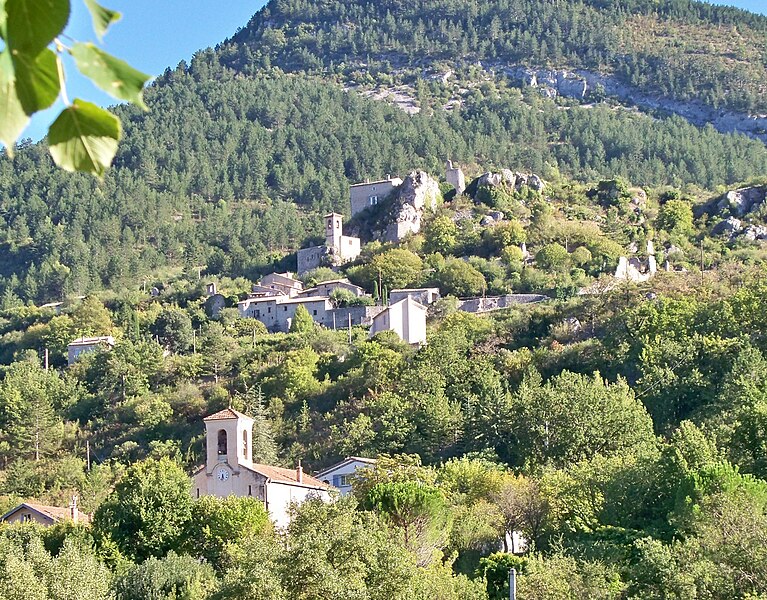
Saint-May (Saint-May)

- коммуна во Франции
 Hiking in Saint-May
Saint-May is a charming area situated in the Auvergne-Rhône-Alpes region of France, near the Vercors Massif, which offers a variety of hiking opportunities. Here are some highlights for hikers in and around Saint-May:
Scenery and Terrain
- Diverse Landscape: The region features lush forests, sweeping valleys, and stunning mountainous terrain, making it suitable for various hiking levels.
- Natural Beauty: As you hike, you can expect to see scenic views, including impressive limestone cliffs, rivers, and unique flora and fauna.
Hiking Trails
- Local Trails: There are several marked hiking trails around Saint-May, ranging from easy walks to challenging ascents. Always check local maps or visitor centers for updated trail information.
- Vercors National Park: A short drive from Saint-May, the Vercors National Park offers well-maintained trails. Popular hikes include the Gorges de la Bourne and the ascent to the Grand Veymont, the highest peak in the Vercors.
Best Times to Hike
- Spring and Autumn: These seasons provide pleasant temperatures and vibrant scenery, making them ideal for hiking.
- Summer: While the weather is warmer, it's essential to start early to avoid the midday heat, especially on longer trails.
Hiking Tips
- Gear Up: Wear sturdy hiking boots and bring plenty of water, snacks, and sunscreen. It's also advisable to have a good map or GPS.
- Be Prepared: Weather in the mountains can change rapidly, so dress in layers and be prepared for conditions that can shift throughout the day.
Safety
- Wildlife: Be aware of the local wildlife and inform yourself about any potential hazards, including steep areas or slippery trails.
- Trail Etiquette: Follow the Leave No Trace principles to keep the trails clean and preserve the natural beauty for future hikers.
Whether you are a seasoned hiker or a beginner, Saint-May and the surrounding areas offer a fantastic opportunity to explore nature and enjoy the stunning landscapes of the Auvergne-Rhône-Alpes region. Happy hiking!
- Страна:

- Почтовый код: 26510
- Координаты: 44° 25' 36" N, 5° 19' 6" E


- GPS треки (wikiloc): [Ссылка]
- Площадь: 10.23 кв.км
- Население: 41
- Википедия английская: wiki(en)
- Википедия национальная: wiki(fr)
- Хранилище Wikidata: Wikidata: Q219391
- Катеория в википедии: [Ссылка]
- код Freebase: [/m/03mhkxz]
- код GeoNames: Альт: [6430226]
- номер SIREN: [212603187]
- код BNF: [152531785]
- код муниципалитета INSEE: 26318
Граничит с регионами:

Sahune
- коммуна во Франции
Hiking in Sahune
Sahune is a charming village located in the Drôme department of the Auvergne-Rhône-Alpes region in southeastern France. It's known for its beautiful landscapes, rolling hills, and proximity to the Vercors Regional Natural Park, making it a great base for hiking enthusiasts....
- Страна:
- Почтовый код: 26510
- Координаты: 44° 24' 53" N, 5° 16' 2" E
- GPS треки (wikiloc): [Ссылка]
- Площадь: 16.55 кв.км
- Население: 312


Villeperdrix
- коммуна во Франции
Hiking in Villeperdrix
Villeperdrix is a charming village located in the southern part of France, in the Drôme department within the Auvergne-Rhône-Alpes region. Nestled in the foothills of the Vercors mountain range, it offers stunning landscapes and excellent hiking opportunities for outdoor enthusiasts....
- Страна:
- Почтовый код: 26510
- Координаты: 44° 26' 31" N, 5° 17' 17" E
- GPS треки (wikiloc): [Ссылка]
- Площадь: 26.15 кв.км
- Население: 116
- Веб сайт: [Ссылка]


Rémuzat
- коммуна во Франции
Hiking in Rémuzat
Rémuzat, located in the Drôme department in southeastern France, is a fantastic destination for hiking enthusiasts. Nestled in the stunning landscape of the Vercors Regional Natural Park and the Baronnies Provençales Regional Natural Park, it offers diverse terrains, beautiful vistas, and a mix of challenging trails and gentle hikes for all levels....
- Страна:
- Почтовый код: 26510
- Координаты: 44° 24' 49" N, 5° 21' 23" E
- GPS треки (wikiloc): [Ссылка]
- Площадь: 16.78 кв.км
- Население: 361


Le Poët-Sigillat
- коммуна во Франции
Hiking in Le Poët-Sigillat
Le Poët-Sigillat is a small village located in the Drôme department of the Auvergne-Rhône-Alpes region in southeastern France. The area is known for its picturesque landscapes and tranquil environment, making it a great destination for hiking enthusiasts....
- Страна:
- Почтовый код: 26110
- Координаты: 44° 22' 8" N, 5° 19' 1" E
- GPS треки (wikiloc): [Ссылка]
- Площадь: 15.36 кв.км
- Население: 119


Cornillon-sur-l'Oule
- коммуна во Франции
Hiking in Cornillon-sur-l'Oule
Cornillon-sur-l'Oule is a picturesque village located in the Drôme department in the Auvergne-Rhône-Alpes region of southeastern France. It is surrounded by stunning landscapes, including options for hiking that allow you to experience the natural beauty of the area....
- Страна:
- Почтовый код: 26510
- Координаты: 44° 27' 31" N, 5° 22' 4" E
- GPS треки (wikiloc): [Ссылка]
- Площадь: 14.55 кв.км
- Население: 69


Montréal-les-Sources
- коммуна во Франции
Hiking in Montréal-les-Sources
Montréal-les-Sources, located in the beautiful region of Quebec, offers stunning natural landscapes and a variety of hiking trails for outdoor enthusiasts. Here are some key points to consider when hiking in this area:...
- Страна:
- Почтовый код: 26510
- Координаты: 44° 24' 5" N, 5° 18' 0" E
- GPS треки (wikiloc): [Ссылка]
- Площадь: 10.26 кв.км
- Население: 26