canton of Rémuzat (canton de Rémuzat)
 Hiking in canton of Rémuzat
The Canton of Rémuzat, located in the Drôme department of southeastern France, is a beautiful area for hiking, renowned for its stunning landscapes and diverse terrain. It is part of the larger Vercors Regional Natural Park, which offers a variety of trails suitable for all levels, from beginners to advanced hikers.
Key Features:
-
Scenic Views: The region is characterized by dramatic cliffs, deep gorges, lush valleys, and panoramic views of the surrounding mountains. The landscape is particularly stunning during the spring and autumn when the foliage changes color.
-
Diverse Trails: There are numerous hiking trails in and around Rémuzat. Many trails traverse the iconic Vercors plateau, offering opportunities to explore its unique flora and fauna. Look out for trails that lead to viewpoints like the Rocher de la Jaillère or the Col de la Machine.
-
Historical Sites: Along many trails, you can discover historical and cultural sites, including ancient ruins, charming villages, and local churches that add a cultural dimension to your hike.
-
Wildlife Watching: The area is home to a variety of wildlife including birds of prey, deer, and endemic plant species, making it a great spot for nature enthusiasts.
-
Seasonal Activities: While hiking is popular in the warmer months, Rémuzat also has opportunities for cross-country skiing and snowshoeing in winter, allowing for year-round outdoor activities.
Tips for Hiking in Rémuzat:
- Weather Considerations: The weather can change quickly in the mountains, so check forecasts and be prepared for varying conditions. Layered clothing, sturdy footwear, and appropriate gear are essential.
- Trail Maps: It’s recommended to carry a detailed map or GPS device, as some trails may not be well-marked. Local tourist offices can provide maps and information on trail conditions.
- Respect Nature: Follow Leave No Trace principles to preserve the beauty of the area. Stay on marked trails and avoid disturbing wildlife.
- Hydration and Snacks: Carry enough water and snacks, especially for longer hikes, as facilities may be limited on the trails.
Getting There:
Rémuzat is accessible by road, and it's advisable to have a car for ease of exploring the various hiking locations. There are also accommodations such as guesthouses and campsites for those who wish to spend more time in this beautiful part of France.
Overall, hiking in the Canton of Rémuzat allows you to immerse yourself in nature while enjoying breathtaking scenery, making it a rewarding experience for outdoor lovers.
- Страна:

- Столица: Rémuzat
- Координаты: 44° 24' 2" N, 5° 23' 21" E


- GPS треки (wikiloc): [Ссылка]
- Википедия английская: wiki(en)
- Википедия национальная: wiki(fr)
- Хранилище Wikidata: Wikidata: Q613961
- код Freebase: [/m/0gxyy7m]
- код кантона INSEE: [2620]
Включает регионы:


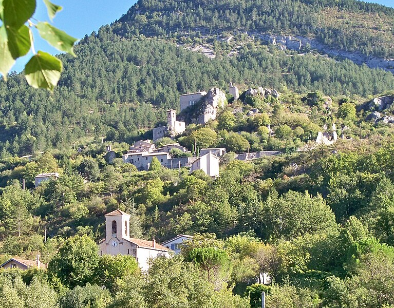
Pelonne
Hiking in Pelonne
Pelonne is not widely recognized as a notable hiking destination, and it's possible you may be referring to a different location or there might be a lesser-known area with that name. If you meant "Pelón" or another similar-sounding destination, I could provide information on popular hiking spots in nearby regions....
- Страна:
- Почтовый код: 26510
- Координаты: 44° 22' 59" N, 5° 23' 33" E
- GPS треки (wikiloc): [Ссылка]
- Площадь: 2.77 кв.км
- Население: 22

Sahune
- коммуна во Франции
Hiking in Sahune
Sahune is a charming village located in the Drôme department of the Auvergne-Rhône-Alpes region in southeastern France. It's known for its beautiful landscapes, rolling hills, and proximity to the Vercors Regional Natural Park, making it a great base for hiking enthusiasts....
- Страна:
- Почтовый код: 26510
- Координаты: 44° 24' 53" N, 5° 16' 2" E
- GPS треки (wikiloc): [Ссылка]
- Площадь: 16.55 кв.км
- Население: 312


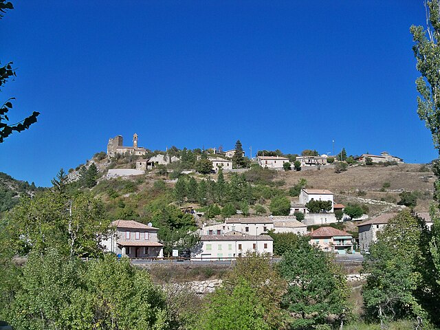
Saint-May
- коммуна во Франции
Hiking in Saint-May
Saint-May is a charming area situated in the Auvergne-Rhône-Alpes region of France, near the Vercors Massif, which offers a variety of hiking opportunities. Here are some highlights for hikers in and around Saint-May:...
- Страна:
- Почтовый код: 26510
- Координаты: 44° 25' 36" N, 5° 19' 6" E
- GPS треки (wikiloc): [Ссылка]
- Площадь: 10.23 кв.км
- Население: 41
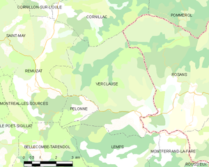
Verclause
- коммуна во Франции
Hiking in Verclause
Verclause, while not a widely known hiking destination, offers beautiful natural scenery and outdoor activities for hiking enthusiasts. It is likely part of a region that features picturesque landscapes, including perhaps rolling hills, forests, and potentially even rivers or lakes, depending on its geography....
- Страна:
- Почтовый код: 26510
- Координаты: 44° 22' 50" N, 5° 25' 40" E
- GPS треки (wikiloc): [Ссылка]
- Площадь: 26.14 кв.км
- Население: 62


Villeperdrix
- коммуна во Франции
Hiking in Villeperdrix
Villeperdrix is a charming village located in the southern part of France, in the Drôme department within the Auvergne-Rhône-Alpes region. Nestled in the foothills of the Vercors mountain range, it offers stunning landscapes and excellent hiking opportunities for outdoor enthusiasts....
- Страна:
- Почтовый код: 26510
- Координаты: 44° 26' 31" N, 5° 17' 17" E
- GPS треки (wikiloc): [Ссылка]
- Площадь: 26.15 кв.км
- Население: 116
- Веб сайт: [Ссылка]


Rémuzat
- коммуна во Франции
Hiking in Rémuzat
Rémuzat, located in the Drôme department in southeastern France, is a fantastic destination for hiking enthusiasts. Nestled in the stunning landscape of the Vercors Regional Natural Park and the Baronnies Provençales Regional Natural Park, it offers diverse terrains, beautiful vistas, and a mix of challenging trails and gentle hikes for all levels....
- Страна:
- Почтовый код: 26510
- Координаты: 44° 24' 49" N, 5° 21' 23" E
- GPS треки (wikiloc): [Ссылка]
- Площадь: 16.78 кв.км
- Население: 361


Montferrand-la-Fare
- коммуна во Франции
Hiking in Montferrand-la-Fare
Montferrand-la-Fare is a charming commune located in the Provence-Alpes-Côte d'Azur region of southeastern France, particularly known for its picturesque landscapes and natural beauty. Hiking in this area can provide you with a wonderful experience, as it combines scenic views with the tranquility of rural France....
- Страна:
- Почтовый код: 26510
- Координаты: 44° 21' 36" N, 5° 26' 59" E
- GPS треки (wikiloc): [Ссылка]
- Высота над уровнем моря: 670 м m
- Площадь: 11.24 кв.км
- Население: 31


Lemps
- коммуна во Франции
Hiking in Lemps
Lemps, located in the Drôme department of France, offers a charming setting for hiking enthusiasts with its picturesque landscapes and varied terrain. The region is characterized by rolling hills, vineyards, and small villages, providing a peaceful backdrop for outdoor adventures....
- Страна:
- Почтовый код: 26510
- Координаты: 44° 21' 4" N, 5° 25' 8" E
- GPS треки (wikiloc): [Ссылка]
- Высота над уровнем моря: 774 м m
- Площадь: 16.04 кв.км
- Население: 47


Pommerol
- коммуна во Франции
Hiking in Pommerol
Pommerol, located in the heart of the French Alps, is a charming destination for hiking enthusiasts. The region is known for its stunning landscapes, diverse terrains, and picturesque villages. Here are some highlights and tips for hiking in Pommerol:...
- Страна:
- Почтовый код: 26470
- Координаты: 44° 26' 46" N, 5° 27' 8" E
- GPS треки (wikiloc): [Ссылка]
- Высота над уровнем моря: 890 м m
- Площадь: 9.83 кв.км
- Население: 20


Le Poët-Sigillat
- коммуна во Франции
Hiking in Le Poët-Sigillat
Le Poët-Sigillat is a small village located in the Drôme department of the Auvergne-Rhône-Alpes region in southeastern France. The area is known for its picturesque landscapes and tranquil environment, making it a great destination for hiking enthusiasts....
- Страна:
- Почтовый код: 26110
- Координаты: 44° 22' 8" N, 5° 19' 1" E
- GPS треки (wikiloc): [Ссылка]
- Площадь: 15.36 кв.км
- Население: 119


Cornillon-sur-l'Oule
- коммуна во Франции
Hiking in Cornillon-sur-l'Oule
Cornillon-sur-l'Oule is a picturesque village located in the Drôme department in the Auvergne-Rhône-Alpes region of southeastern France. It is surrounded by stunning landscapes, including options for hiking that allow you to experience the natural beauty of the area....
- Страна:
- Почтовый код: 26510
- Координаты: 44° 27' 31" N, 5° 22' 4" E
- GPS треки (wikiloc): [Ссылка]
- Площадь: 14.55 кв.км
- Население: 69


Cornillac
- коммуна во Франции
Hiking in Cornillac
Cornillac is a lesser-known gem located in the French Alps, making it an ideal destination for hiking enthusiasts seeking scenic views and challenging trails. While not as crowded as some more popular destinations, it offers a variety of hiking opportunities suitable for different skill levels....
- Страна:
- Почтовый код: 26510
- Координаты: 44° 26' 35" N, 5° 23' 11" E
- GPS треки (wikiloc): [Ссылка]
- Площадь: 19.44 кв.км
- Население: 81


Chauvac-Laux-Montaux
- коммуна во Франции
Hiking in Chauvac-Laux-Montaux
Chauvac-Laux-Montaux is a beautiful area located in the Dauphiné Alps of France, known for its stunning landscapes, diverse wildlife, and excellent hiking opportunities. The region is characterized by its mountainous terrain, picturesque valleys, and a variety of trails suitable for hikers of different levels....
- Страна:
- Почтовый код: 26510
- Координаты: 44° 19' 17" N, 5° 31' 32" E
- GPS треки (wikiloc): [Ссылка]
- Площадь: 24.24 кв.км
- Население: 44

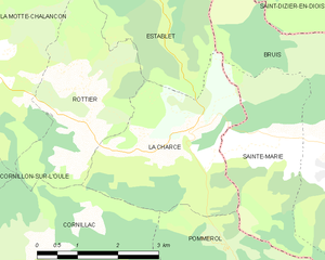
La Charce
- коммуна во Франции
Hiking in La Charce
La Charce is a beautiful area located in the southern region of the Drôme department in France. It's known for its stunning landscapes, diverse flora and fauna, and serene hiking trails. Here’s some information to help you plan your hiking adventure in La Charce:...
- Страна:
- Почтовый код: 26470
- Координаты: 44° 28' 14" N, 5° 27' 3" E
- GPS треки (wikiloc): [Ссылка]
- Площадь: 9.43 кв.км
- Население: 35


Montréal-les-Sources
- коммуна во Франции
Hiking in Montréal-les-Sources
Montréal-les-Sources, located in the beautiful region of Quebec, offers stunning natural landscapes and a variety of hiking trails for outdoor enthusiasts. Here are some key points to consider when hiking in this area:...
- Страна:
- Почтовый код: 26510
- Координаты: 44° 24' 5" N, 5° 18' 0" E
- GPS треки (wikiloc): [Ссылка]
- Площадь: 10.26 кв.км
- Население: 26


Roussieux
- коммуна во Франции
Hiking in Roussieux
Roussieux is a charming village located in the Drôme department of the Auvergne-Rhône-Alpes region in southeastern France. It's surrounded by beautiful landscapes, characterized by rolling hills, forests, and rivers, offering great opportunities for hiking enthusiasts....
- Страна:
- Почтовый код: 26510
- Координаты: 44° 19' 59" N, 5° 28' 25" E
- GPS треки (wikiloc): [Ссылка]
- Площадь: 9.42 кв.км
- Население: 23