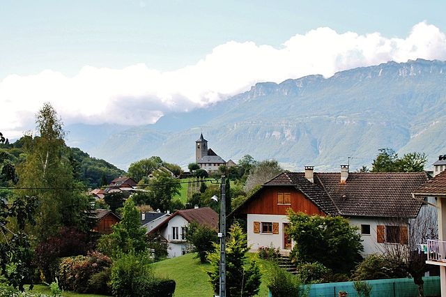
Saint-Pierre-de-Soucy (Saint-Pierre-de-Soucy)

- коммуна во Франции
 Hiking in Saint-Pierre-de-Soucy
Saint-Pierre-de-Soucy is a charming municipality in Quebec, Canada, known for its beautiful natural landscapes and outdoor recreational opportunities. Here are some highlights related to hiking in this area:
-
Natural Scenery: The region is characterized by lush forests, rolling hills, and scenic views. The diverse ecosystems provide a habitat for various wildlife, making it an attractive destination for nature enthusiasts.
-
Trails: While Saint-Pierre-de-Soucy may not have extensive dedicated hiking trails like some larger national parks, there are often local paths, logging roads, and access to surrounding natural areas where you can hike. Be sure to check with local tourism offices or community boards for maps and information on trail conditions.
-
Nearby Parks: The area is in proximity to larger parks like Parc national de la Mauricie, offering more structured hiking options with a variety of trails ranging from easy to challenging. These parks provide well-marked paths and breathtaking views.
-
Hiking Season: Spring through fall is the best time for hiking in Quebec, with vibrant foliage in the fall particularly stunning. Winter hiking and snowshoeing are also popular, but be prepared for colder temperatures and potential snow-covered trails.
-
Safety and Preparedness: Always plan ahead when hiking. Carry essential gear such as a map, compass, water, snacks, and a first-aid kit. Hiking alone can be rewarding, but it’s wise to inform someone of your plans and expected return time.
-
Local Tips: Talk to local residents or check online forums for insider information on the best spots and trails. They can provide insights into hidden gems and current trail conditions.
Hiking in and around Saint-Pierre-de-Soucy offers a peaceful retreat into nature, perfect for those looking to escape the bustling city life and enjoy the great outdoors.
- Страна:

- Почтовый код: 73800
- Координаты: 45° 29' 39" N, 6° 6' 22" E


- GPS треки (wikiloc): [Ссылка]
- Площадь: 9.09 кв.км
- Население: 434
- Википедия английская: wiki(en)
- Википедия национальная: wiki(fr)
- Хранилище Wikidata: Wikidata: Q778863
- Катеория в википедии: [Ссылка]
- код Freebase: [/m/03npfsk]
- код GeoNames: Альт: [6442901]
- номер SIREN: [217302769]
- код BNF: [15274207k]
- код муниципалитета INSEE: 73276
Граничит с регионами:


La Croix-de-la-Rochette
- коммуна во Франции
Hiking in La Croix-de-la-Rochette
La Croix-de-la-Rochette is a charming area located in the French Alps, known for its stunning landscapes and outdoor recreational opportunities. Hiking in this region offers a variety of trails suited to different skill levels, ranging from easy walks to more challenging hikes. Here are some highlights of hiking in La Croix-de-la-Rochette:...
- Страна:
- Почтовый код: 73110
- Координаты: 45° 28' 1" N, 6° 7' 8" E
- GPS треки (wikiloc): [Ссылка]
- Площадь: 3.04 кв.км
- Население: 340


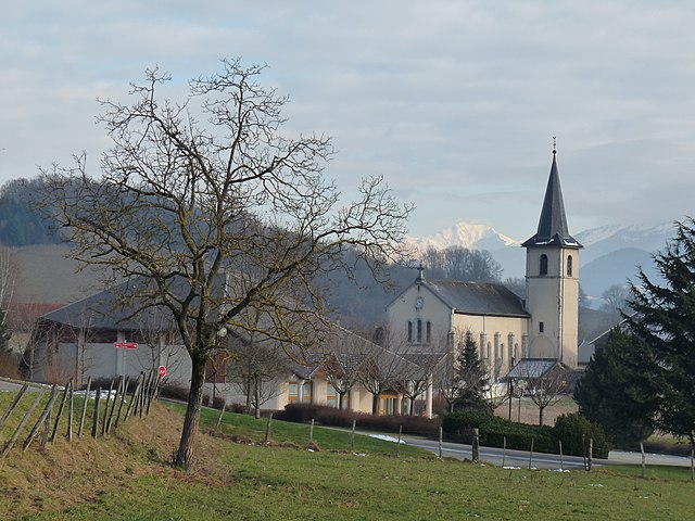
La Rochette
Hiking in La Rochette
La Rochette, located in the Savoie region of the French Alps, offers a range of hiking opportunities for both beginners and experienced hikers. The area is known for its stunning alpine scenery, with impressive mountain views, lush forests, and scenic valleys....
- Страна:
- Почтовый код: 73110
- Координаты: 45° 27' 31" N, 6° 7' 13" E
- GPS треки (wikiloc): [Ссылка]
- Площадь: 4.66 кв.км
- Население: 3694
- Веб сайт: [Ссылка]
Villaroux
- коммуна во Франции
Hiking in Villaroux
Villaroux is a beautiful area for hiking, situated in the French Alps. It's known for its breathtaking landscapes, diverse flora and fauna, and a variety of trails that cater to different skill levels. Here are some details you might find useful if you're considering hiking in Villaroux:...
- Страна:
- Почтовый код: 73110
- Координаты: 45° 27' 29" N, 6° 4' 30" E
- GPS треки (wikiloc): [Ссылка]
- Площадь: 3.09 кв.км
- Население: 216


Villard-Sallet
- коммуна во Франции
Hiking in Villard-Sallet
Villard-Sallet is a picturesque destination located in the French Alps, known for its stunning landscapes and outdoor activities, particularly hiking. Nestled at the heart of nature, it's a great spot for both novice and experienced hikers. Here are some key highlights and tips for hiking in Villard-Sallet:...
- Страна:
- Почтовый код: 73110
- Координаты: 45° 29' 7" N, 6° 8' 18" E
- GPS треки (wikiloc): [Ссылка]
- Площадь: 3.14 кв.км
- Население: 289
Villard-d'Héry
- коммуна во Франции
Hiking in Villard-d'Héry
Villard-d'Héry is a charming village located in the Savoie region of the French Alps. It's an excellent starting point for various hiking adventures, with picturesque landscapes, alpine meadows, and mountainous terrain. Here are some highlights and tips for hiking in the area:...
- Страна:
- Почтовый код: 73800
- Координаты: 45° 30' 52" N, 6° 8' 16" E
- GPS треки (wikiloc): [Ссылка]
- Площадь: 4.9 кв.км
- Население: 264

Les Mollettes
- коммуна во Франции
Hiking in Les Mollettes
Les Mollettes is a beautiful hiking destination located in the French Alps, specifically in the Savoie region. The area is known for its stunning natural landscapes, diverse wildlife, and a variety of hiking trails suitable for all levels of experience....
- Страна:
- Почтовый код: 73800
- Координаты: 45° 27' 39" N, 6° 3' 15" E
- GPS треки (wikiloc): [Ссылка]
- Площадь: 5.47 кв.км
- Население: 798
- Веб сайт: [Ссылка]

Sainte-Hélène-du-Lac
- коммуна во Франции
Hiking in Sainte-Hélène-du-Lac
Sainte-Hélène-du-Lac is a picturesque commune in the Savoie region of France, nestled in the French Alps. It's a great destination for hikers because of its stunning landscapes, diverse trails, and proximity to the Maurienne Valley and the Chartreuse Mountains....
- Страна:
- Почтовый код: 73800
- Координаты: 45° 28' 56" N, 6° 3' 57" E
- GPS треки (wikiloc): [Ссылка]
- Площадь: 7.09 кв.км
- Население: 767
- Веб сайт: [Ссылка]
La Trinité, Savoie
Hiking in La Trinité, Savoie
La Trinité, located in the Savoie region of the French Alps, offers a stunning backdrop for hiking enthusiasts. While it may be less well-known than some of the more famous alpine areas, the region is characterized by beautiful landscapes, intricate trails, and the opportunity to experience the local flora and fauna....
- Страна:
- Почтовый код: 73110
- Координаты: 45° 29' 55" N, 6° 8' 52" E
- GPS треки (wikiloc): [Ссылка]
- Площадь: 4.88 кв.км
- Население: 342


Coise-Saint-Jean-Pied-Gauthier
- коммуна во Франции
Hiking in Coise-Saint-Jean-Pied-Gauthier
Coise-Saint-Jean-Pied-Gauthier, located in the Savoie region of the French Alps, offers stunning hiking opportunities amidst beautiful mountainous landscapes. While specific trails may vary in difficulty and length, here are some general points to consider when hiking in this area:...
- Страна:
- Почтовый код: 73800
- Координаты: 45° 31' 32" N, 6° 8' 33" E
- GPS треки (wikiloc): [Ссылка]
- Площадь: 10.38 кв.км
- Население: 1219