Sainte-Hélène-du-Lac (Sainte-Hélène-du-Lac)

- коммуна во Франции
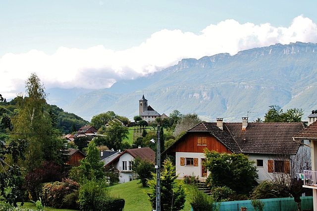
 Hiking in Sainte-Hélène-du-Lac
Sainte-Hélène-du-Lac is a picturesque commune in the Savoie region of France, nestled in the French Alps. It's a great destination for hikers because of its stunning landscapes, diverse trails, and proximity to the Maurienne Valley and the Chartreuse Mountains.
Hiking Trails:
-
Local Nature Trails: There are various local trails that cater to different skill levels. These often feature beautiful views of the surrounding mountains, forests, and lakes.
-
Mont Granier: A notable hike in the area is the trail leading to Mont Granier, which offers panoramic views of the Savoie region. A moderately challenging hike, it's suitable for those with some hiking experience.
-
Sentier de Découverte: This is a discovery trail that combines hiking with educational elements about the local flora and fauna. It's a gentler walk, ideal for families or casual hikers.
-
Lac de Saint-Jean: A hike to the nearby Lac de Saint-Jean offers a serene experience by the lake, with opportunities for picnicking and taking in the tranquil scenery.
Tips for Hiking in Sainte-Hélène-du-Lac:
- Check the Weather: Mountain weather can change rapidly, so make sure to check the forecast before heading out.
- Stay Hydrated and Nourished: Bring enough water and snacks, especially for longer hikes.
- Wear Appropriate Gear: Good hiking shoes, weather-appropriate clothing, and sun protection are essential.
- Take a Map: While many trails are marked, having a map and understanding the route is important, especially for more remote areas.
- Respect Nature: Follow the principles of Leave No Trace to preserve the natural beauty of the area.
Nearby Attractions:
- Chambéry: The nearby city offers historical sites and cultural experiences.
- Historic Villages: Explore local villages around Sainte-Hélène-du-Lac for a taste of Savoyard culture and cuisine.
Overall, Sainte-Hélène-du-Lac provides a great base for hiking enthusiasts looking to enjoy the breathtaking beauty of the French Alps.
- Страна:

- Почтовый код: 73800
- Координаты: 45° 28' 56" N, 6° 3' 57" E


- GPS треки (wikiloc): [Ссылка]
- Площадь: 7.09 кв.км
- Население: 767
- Веб сайт: https://www.saintehelenedulac.com/
- Википедия английская: wiki(en)
- Википедия национальная: wiki(fr)
- Хранилище Wikidata: Wikidata: Q636773
- Катеория в википедии: [Ссылка]
- код Freebase: [/m/03npggp]
- код GeoNames: Альт: [6442874]
- номер SIREN: [217302405]
- код BNF: [15274171d]
- код муниципалитета INSEE: 73240
Граничит с регионами:


Монмельян
- коммуна во Франции
Hiking in Монмельян
Montmélian, located in the Savoie region of France, is an excellent destination for hiking enthusiasts. Nestled at the foot of the Alps, it offers a variety of trails that cater to all skill levels, from beginners to experienced hikers. Here are some highlights and tips for hiking in Montmélian:...
- Страна:
- Почтовый код: 73800
- Координаты: 45° 30' 10" N, 6° 3' 13" E
- GPS треки (wikiloc): [Ссылка]
- Площадь: 5.69 кв.км
- Население: 4112

Les Mollettes
- коммуна во Франции
Hiking in Les Mollettes
Les Mollettes is a beautiful hiking destination located in the French Alps, specifically in the Savoie region. The area is known for its stunning natural landscapes, diverse wildlife, and a variety of hiking trails suitable for all levels of experience....
- Страна:
- Почтовый код: 73800
- Координаты: 45° 27' 39" N, 6° 3' 15" E
- GPS треки (wikiloc): [Ссылка]
- Площадь: 5.47 кв.км
- Население: 798
- Веб сайт: [Ссылка]


Planaise
- коммуна во Франции
Hiking in Planaise
Planaise, located in the French Alps, is a fantastic destination for hiking enthusiasts. The area is known for its stunning landscapes, ranging from alpine meadows to rugged mountain terrain. Here’s what you should know about hiking in Planaise:...
- Страна:
- Почтовый код: 73800
- Координаты: 45° 30' 12" N, 6° 5' 26" E
- GPS треки (wikiloc): [Ссылка]
- Площадь: 4.16 кв.км
- Население: 520
- Веб сайт: [Ссылка]


Francin
- коммуна во Франции
Hiking in Francin
Hiking in Francin, which is located in the Auvergne-Rhône-Alpes region of France, offers stunning natural beauty and a variety of trails suitable for different skill levels. The region is characterized by its picturesque landscapes, rolling hills, and diverse flora and fauna....
- Страна:
- Почтовый код: 73800
- Координаты: 45° 30' 0" N, 6° 2' 4" E
- GPS треки (wikiloc): [Ссылка]
- Площадь: 6.93 кв.км
- Население: 925
- Веб сайт: [Ссылка]


Coise-Saint-Jean-Pied-Gauthier
- коммуна во Франции
Hiking in Coise-Saint-Jean-Pied-Gauthier
Coise-Saint-Jean-Pied-Gauthier, located in the Savoie region of the French Alps, offers stunning hiking opportunities amidst beautiful mountainous landscapes. While specific trails may vary in difficulty and length, here are some general points to consider when hiking in this area:...
- Страна:
- Почтовый код: 73800
- Координаты: 45° 31' 32" N, 6° 8' 33" E
- GPS треки (wikiloc): [Ссылка]
- Площадь: 10.38 кв.км
- Население: 1219


Saint-Pierre-de-Soucy
- коммуна во Франции
Hiking in Saint-Pierre-de-Soucy
Saint-Pierre-de-Soucy is a charming municipality in Quebec, Canada, known for its beautiful natural landscapes and outdoor recreational opportunities. Here are some highlights related to hiking in this area:...
- Страна:
- Почтовый код: 73800
- Координаты: 45° 29' 39" N, 6° 6' 22" E
- GPS треки (wikiloc): [Ссылка]
- Площадь: 9.09 кв.км
- Население: 434


Laissaud
- коммуна во Франции
Hiking in Laissaud
Laissaud is a beautiful area located in the French Alps, known for its stunning scenery and diverse hiking opportunities. The region offers a variety of trails suitable for different skill levels, from gentle walks to more challenging treks. Here's some information to help you plan your hiking experience in Laissaud:...
- Страна:
- Почтовый код: 73800
- Координаты: 45° 26' 49" N, 6° 2' 13" E
- GPS треки (wikiloc): [Ссылка]
- Площадь: 6.57 кв.км
- Население: 660


La Chavanne
- коммуна во Франции
Hiking in La Chavanne
La Chavanne is a picturesque area located in the French Alps, known for its stunning landscapes and hiking trails. While specific trails may vary by season and accessibility, here are some general points to consider when hiking in La Chavanne:...
- Страна:
- Почтовый код: 73800
- Координаты: 45° 29' 42" N, 6° 4' 30" E
- GPS треки (wikiloc): [Ссылка]
- Площадь: 3.06 кв.км
- Население: 637
- Веб сайт: [Ссылка]