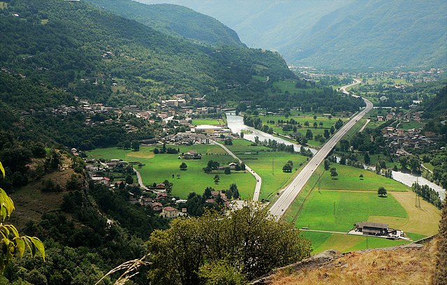
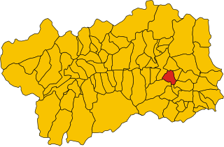
Сен-Венсан (Saint-Vincent, Aosta Valley, Saint-Vincent)
.svg)
- коммуна Италии
 Hiking in Сен-Венсан
Saint-Vincent is a charming town located in the Aosta Valley region of Italy, nestled in the beautiful mountains of the Alps. The area is known not only for its rich history and thermal baths but also for its excellent hiking opportunities. Here are some key points about hiking in and around Saint-Vincent:
Trail Options
-
Val d'Ayas and Val di Champorcher: Both valleys offer a variety of well-marked trails suitable for different skill levels. You can explore stunning alpine landscapes, including lush meadows, forests, and breathtaking mountain views.
-
Mont Avic Natural Park: This park is nearby and features numerous trails, including those leading to glacial lakes and panoramic viewpoints. Trails range from easy walks to more challenging hikes, providing options for beginners and experienced hikers alike.
-
Col de Joux: A popular starting point for many hikes in the region. From here, you can reach various summits and enjoy spectacular views.
-
Sentiero dei Giardini: An easier trail that offers a wonderful opportunity to explore local flora and fauna while taking in views of the surrounding mountains.
Hiking Conditions
- Season: The best time for hiking in Saint-Vincent is typically from late spring to early autumn (May to October). During these months, weather conditions are usually favorable, and the trails are accessible.
- Weather: Be prepared for changing weather conditions in the mountains. It's advisable to check the forecast before heading out and dress in layers.
Tips for Hikers
- Maps and Guides: Always carry a detailed map or guidebook of the area. There are several resources available both online and at local tourist information centers.
- Safety: Inform someone about your hiking plans and estimated return time. Always carry a first aid kit, sufficient water, and snacks.
- Gear: Good hiking shoes are essential. Trekking poles can also be helpful, especially on steep trails.
Local Attractions
After hiking, you might want to relax in the thermal baths of Saint-Vincent or explore the town’s historic sites, including the Church of Saint Vincent and local parks.
Hiking around Saint-Vincent offers a fantastic way to experience the natural beauty and tranquility of the Italian Alps, making it a delightful destination for outdoor enthusiasts.
- Страна:

- Почтовый код: 11027
- Телефонный код: 0166
- Код автомобильного номера: AO
- Координаты: 45° 45' 0" N, 7° 39' 0" E


- GPS треки (wikiloc): [Ссылка]
- Высота над уровнем моря: 550 м m
- Площадь: 20.57 кв.км
- Население: 4584
- Веб сайт: http://www.comune.saint-vincent.ao.it
- Википедия русская: wiki(ru)
- Википедия английская: wiki(en)
- Википедия национальная: wiki(it)
- Хранилище Wikidata: Wikidata: Q35436
- Катеория в википедии: [Ссылка]
- Карты в википедии: [Ссылка]
- код Freebase: [/m/0fwz9r]
- код GeoNames: Альт: [6535876]
- ID отношения в OpenStreetMap: [2530]
- код Цифрового атласа Римской империи: [42087]
- код ISTAT: 007065
- кадастровый код Италии: H676
Граничит с регионами:


Аяс
- коммуна Италии
Hiking in Аяс
Ayas, located in the Aosta Valley region of Italy, is a stunning area known for its picturesque landscapes, charming alpine villages, and a variety of hiking trails that cater to different experience levels. Here are some highlights and recommendations for hiking in Ayas:...
- Страна:
- Почтовый код: 11020
- Телефонный код: 0125
- Код автомобильного номера: AO
- Координаты: 45° 48' 41" N, 7° 41' 12" E
- GPS треки (wikiloc): [Ссылка]
- Высота над уровнем моря: 1698 м m
- Площадь: 129.42 кв.км
- Население: 1377
- Веб сайт: [Ссылка]


Брюссон
- коммуна Италии
Hiking in Брюссон
Brusson is a charming village located in the Aosta Valley region of Italy, known for its stunning natural scenery and excellent hiking opportunities. Nestled in the midst of the Alps, Brusson offers a mix of challenging trails and easier walks suitable for hikers of all levels. Here’s what you need to know about hiking in Brusson:...
- Страна:
- Почтовый код: 11022
- Телефонный код: 0125
- Код автомобильного номера: AO
- Координаты: 45° 46' 0" N, 7° 44' 0" E
- GPS треки (wikiloc): [Ссылка]
- Высота над уровнем моря: 1338 м m
- Площадь: 55.26 кв.км
- Население: 887
- Веб сайт: [Ссылка]


Шатийон
- коммуна Италии
Hiking in Шатийон
Châtillon is a charming town located in the Aosta Valley region of Italy, surrounded by stunning mountainous landscapes that make it a great starting point for hiking enthusiasts. Here’s what you should know about hiking in and around Châtillon:...
- Страна:
- Почтовый код: 11024
- Телефонный код: 0166
- Код автомобильного номера: AO
- Координаты: 45° 45' 0" N, 7° 37' 0" E
- GPS треки (wikiloc): [Ссылка]
- Высота над уровнем моря: 549 м m
- Площадь: 39.68 кв.км
- Население: 4654
- Веб сайт: [Ссылка]


Эмарез
- коммуна Италии
Hiking in Эмарез
Émarèse is a charming municipality in the Aosta Valley region of northern Italy, known for its stunning natural landscapes, rich history, and outdoor recreational opportunities. Hiking in Émarèse offers a fantastic way to explore the beauty of the Italian Alps and experience the tranquility of nature....
- Страна:
- Почтовый код: 11020
- Телефонный код: 0166
- Код автомобильного номера: AO
- Координаты: 45° 43' 0" N, 7° 42' 0" E
- GPS треки (wikiloc): [Ссылка]
- Высота над уровнем моря: 1170 м m
- Площадь: 10.23 кв.км
- Население: 227
- Веб сайт: [Ссылка]
Монжове
- коммуна Италии
Hiking in Монжове
Montjovet is a picturesque commune located in the Aosta Valley region of Italy, nestled in the foothills of the Alps. This area is known for its stunning landscapes, diverse ecosystems, and a variety of hiking opportunities that cater to different skill levels. Here are some key points to consider when hiking in Montjovet:...
- Страна:
- Почтовый код: 11020
- Телефонный код: 0166
- Код автомобильного номера: AO
- Координаты: 45° 42' 0" N, 7° 41' 0" E
- GPS треки (wikiloc): [Ссылка]
- Высота над уровнем моря: 406 м m
- Площадь: 18.76 кв.км
- Население: 1774
- Веб сайт: [Ссылка]