Сен-Зашари (Saint-Zacharie, Saint-Zacharie)

- коммуна во Франции
 Hiking in Сен-Зашари
Saint-Zacharie is a charming commune located in the Provence-Alpes-Côte d'Azur region of France, nestled in the foothills of the Sainte-Baume mountain range. The area offers a range of hiking opportunities that cater to various skill levels and preferences, making it an excellent destination for outdoor enthusiasts.
Hiking Trails:
-
GR9 Trail: This long-distance trail runs through the region and offers stunning views of the surrounding landscapes, including mountain vistas and picturesque valleys. The trail is well-marked and provides a chance to experience the local flora and fauna.
-
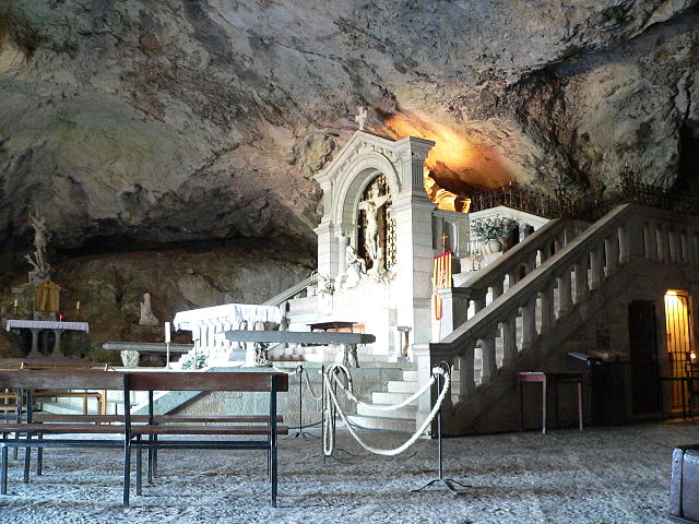
Montagne de la Sainte-Baume: Located nearby, this mountain range is known for its beautiful hiking paths. Trails can vary from easy walks to more challenging hikes, with the possibility of visiting the famous cave of Marie-Madeleine, an important historical site.
-
Local Trails: There are numerous shorter trails around Saint-Zacharie that showcase the natural beauty of the area. These can include paths through forests, olive groves, and vineyards, ideal for a more relaxed hiking experience.
Preparation:
- Maps and Guides: It is advisable to have a good map of the area, as well as to check local guides or websites for trail information and any possible updates regarding conditions.
- Gear: Wear sturdy hiking shoes, and consider taking trekking poles for added support, especially on steeper trails. Bring sufficient water, snacks, and sun protection, particularly during warmer months.
- Weather: The best times to hike in this region are typically in the spring (April to June) and fall (September to October) when the weather is milder.
Safety Tips:
- Always inform someone about your hiking plans and estimated return time.
- Be mindful of local wildlife and stay on marked paths to preserve the natural environment.
- Check weather reports before heading out, as conditions can change rapidly in mountainous areas.
Additional Activities:
Alongside hiking, the region offers opportunities for bird watching, photography, and exploring local culture and cuisine. After a day on the trails, you can enjoy the quaint ambiance of Saint-Zacharie, with its charming cafes and local markets.
Overall, hiking in Saint-Zacharie provides an excellent blend of natural beauty, cultural experience, and recreational activity, making it a great destination for hikers of all levels.
- Страна:

- Почтовый код: 83640
- Координаты: 43° 23' 3" N, 5° 42' 24" E


- GPS треки (wikiloc): [Ссылка]
- Площадь: 27.02 кв.км
- Население: 5392
- Википедия русская: wiki(ru)
- Википедия английская: wiki(en)
- Википедия национальная: wiki(fr)
- Хранилище Wikidata: Wikidata: Q818233
- Катеория в википедии: [Ссылка]
- код Freebase: [/m/03x_x0m]
- код GeoNames: Альт: [6445065]
- номер SIREN: [218301208]
- код BNF: [15277947g]
- код тезауруса PACTOLS: [pcrtkprDjjVu18]
- код муниципалитета INSEE: 83120
Граничит с регионами:

План-д’Опс-Сент-Бом
- коммуна во Франции
Hiking in План-д’Опс-Сент-Бом
Plan-d'Aups-Sainte-Baume is a beautiful destination for hiking enthusiasts, located in the Var department of the Provence-Alpes-Côte d'Azur region of southeastern France. Nestled at the foot of the Sainte-Baume mountain range, this area offers a range of trails that vary in difficulty and scenery....
- Страна:
- Почтовый код: 83640
- Координаты: 43° 19' 48" N, 5° 43' 3" E
- GPS треки (wikiloc): [Ссылка]
- Высота над уровнем моря: 700 м m
- Площадь: 24.91 кв.км
- Население: 2067

Орьоль
- коммуна в департаменте Буш-дю-Рон (Франция)
Hiking in Орьоль
Auriol, located in the Bouches-du-Rhône department in the Provence-Alpes-Côte d'Azur region of southern France, offers a variety of scenic hiking opportunities. Nestled between the Sainte-Baume mountains and the Calanques National Park, Auriol provides a beautiful backdrop with diverse landscapes, from hills and forests to rugged cliffs and Mediterranean flora....
- Страна:
- Почтовый код: 13390
- Координаты: 43° 22' 10" N, 5° 37' 53" E
- GPS треки (wikiloc): [Ссылка]
- Площадь: 44.64 кв.км
- Население: 11538
- Веб сайт: [Ссылка]


Нан-ле-Пен
- коммуна во Франции
Hiking in Нан-ле-Пен
Nans-les-Pins is a charming village located in the Var department in the Provence-Alpes-Côte d'Azur region of France. It's surrounded by beautiful landscapes, making it a great destination for hiking enthusiasts. Here are some highlights of hiking in and around Nans-les-Pins:...
- Страна:
- Почтовый код: 83860
- Координаты: 43° 22' 14" N, 5° 46' 56" E
- GPS треки (wikiloc): [Ссылка]
- Площадь: 47.99 кв.км
- Население: 4276
- Веб сайт: [Ссылка]

Тре
- коммуна во Франции
Hiking in Тре
Trets is a charming town located in the Provence-Alpes-Côte d'Azur region of France, and it offers access to some beautiful hiking opportunities. The surrounding landscape features rolling hills, vineyards, and stunning views of the Sainte-Victoire Mountain, making it an appealing destination for outdoor enthusiasts....
- Страна:
- Почтовый код: 13530
- Координаты: 43° 26' 49" N, 5° 41' 9" E
- GPS треки (wikiloc): [Ссылка]
- Площадь: 70.31 кв.км
- Население: 10963
- Веб сайт: [Ссылка]