Сен-Максимен-ла-Сент-Бом (canton of Saint-Maximin-la-Sainte-Baume, canton de Saint-Maximin-la-Sainte-Baume)

- кантон округа Бриньоль
 Hiking in Сен-Максимен-ла-Сент-Бом
The Canton of Saint-Maximin-la-Sainte-Baume, located in the Provence-Alpes-Côte d'Azur region of southern France, offers a rich variety of hiking opportunities, with beautiful landscapes composed of forests, hills, and scenic views. Here are some highlights about hiking in this area:
1. :
The region is known for its stunning natural scenery, including the Sainte-Baume mountain range, which features limestone cliffs, dense forests, and wildlife. The area is rich in biodiversity, making it ideal for nature lovers.
2. :
There are many hiking trails of varying difficulty levels. Whether you're looking for a challenging hike or a leisurely stroll, you'll find paths that suit your preferences. Popular trails often include well-marked routes through forests and along ridge lines.
3. :
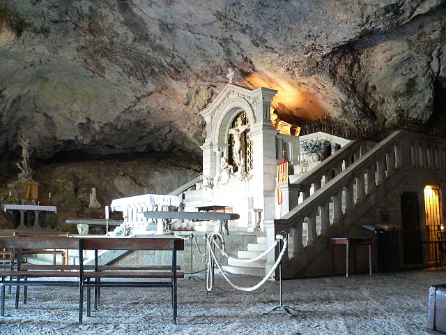
While hiking, you can also explore historical sites, particularly the famous grotto of Sainte Baume, which is associated with legends about Mary Magdalene. Trails leading to such sites provide a blend of natural beauty and cultural significance.
4. :
The Canton is part of a protected natural area, which is home to a diverse range of plant species and wildlife. Hiking here can also provide opportunities for bird watching and observing native plants.
5. :
- Sentier de la Sainte-Baume: A popular route that leads through the forested area toward the iconic grotto.
- Circuit des Cadières: A circular route that offers beautiful views over the surrounding landscape.
- Montagne de la Sainte-Baume: More strenuous trails in this area reward hikers with breathtaking panoramic views.
6. :
- Best Time to Hike: Spring (April to June) and fall (September to October) are ideal seasons due to milder weather and vibrant colors.
- Preparation: Ensure to carry enough water, snacks, a map or GPS, and wear appropriate footwear. Some trails can be rocky or uneven.
- Local Regulations: Always follow local guidelines and respect nature, including staying on marked trails and carrying out any litter.
Hiking in the Canton of Saint-Maximin-la-Sainte-Baume not only provides physical activity but also an opportunity to connect with nature and explore the rich cultural backdrop of the region. Enjoy your hiking experience!
- Страна:

- Столица: Сен-Максимен-ла-Сент-Бом
- Координаты: 43° 27' 0" N, 5° 52' 0" E


- GPS треки (wikiloc): [Ссылка]
- Население: 49814
- Википедия русская: wiki(ru)
- Википедия английская: wiki(en)
- Википедия национальная: wiki(fr)
- Хранилище Wikidata: Wikidata: Q527852
- Катеория в википедии: [Ссылка]
- код кантона INSEE: [8313]
Включает регионы:

План-д’Опс-Сент-Бом
- коммуна во Франции
Hiking in План-д’Опс-Сент-Бом
Plan-d'Aups-Sainte-Baume is a beautiful destination for hiking enthusiasts, located in the Var department of the Provence-Alpes-Côte d'Azur region of southeastern France. Nestled at the foot of the Sainte-Baume mountain range, this area offers a range of trails that vary in difficulty and scenery....
- Страна:
- Почтовый код: 83640
- Координаты: 43° 19' 48" N, 5° 43' 3" E
- GPS треки (wikiloc): [Ссылка]
- Высота над уровнем моря: 700 м m
- Площадь: 24.91 кв.км
- Население: 2067


Ружье
- коммуна во Франции
Hiking in Ружье
Rougiers is a small commune located in the Var department in the Provence-Alpes-Côte d'Azur region of southeastern France. It is surrounded by beautiful natural landscapes, making it an excellent spot for hiking enthusiasts. Here's a guide to hiking in the Rougiers area:...
- Страна:
- Почтовый код: 83170
- Координаты: 43° 23' 33" N, 5° 51' 4" E
- GPS треки (wikiloc): [Ссылка]
- Площадь: 20.53 кв.км
- Население: 1623

Ольер
- коммуна во Франции
Hiking in Ольер
Ollières is a charming commune located in the Var department of the Provence-Alpes-Côte d'Azur region in southeastern France. The region is known for its rolling hills, picturesque landscapes, and Mediterranean climate, making it a great destination for hiking enthusiasts. Here are some highlights and tips for hiking in Ollières:...
- Страна:
- Почтовый код: 83470
- Координаты: 43° 28' 58" N, 5° 49' 47" E
- GPS треки (wikiloc): [Ссылка]
- Площадь: 39.66 кв.км
- Население: 630


Нан-ле-Пен
- коммуна во Франции
Hiking in Нан-ле-Пен
Nans-les-Pins is a charming village located in the Var department in the Provence-Alpes-Côte d'Azur region of France. It's surrounded by beautiful landscapes, making it a great destination for hiking enthusiasts. Here are some highlights of hiking in and around Nans-les-Pins:...
- Страна:
- Почтовый код: 83860
- Координаты: 43° 22' 14" N, 5° 46' 56" E
- GPS треки (wikiloc): [Ссылка]
- Площадь: 47.99 кв.км
- Население: 4276
- Веб сайт: [Ссылка]


Пурсьё
- коммуна во Франции
Hiking in Пурсьё
Pourcieux is a charming village located in the Provence-Alpes-Côte d'Azur region of France. It offers a variety of hiking opportunities that allow you to explore the stunning natural landscapes of the surrounding areas. Here are some highlights and tips for hiking in Pourcieux:...
- Страна:
- Почтовый код: 83470
- Координаты: 43° 28' 13" N, 5° 47' 11" E
- GPS треки (wikiloc): [Ссылка]
- Площадь: 21.23 кв.км
- Население: 1503


Сен-Зашари
- коммуна во Франции
Hiking in Сен-Зашари
Saint-Zacharie is a charming commune located in the Provence-Alpes-Côte d'Azur region of France, nestled in the foothills of the Sainte-Baume mountain range. The area offers a range of hiking opportunities that cater to various skill levels and preferences, making it an excellent destination for outdoor enthusiasts....
- Страна:
- Почтовый код: 83640
- Координаты: 43° 23' 3" N, 5° 42' 24" E
- GPS треки (wikiloc): [Ссылка]
- Площадь: 27.02 кв.км
- Население: 5392

Пурьер
- коммуна во Франции
Hiking in Пурьер
Pourrières is a charming village located in the Var department of the Provence-Alpes-Côte d'Azur region in southeastern France. It is surrounded by beautiful natural landscapes, making it an excellent destination for hiking enthusiasts....
- Страна:
- Почтовый код: 83910
- Координаты: 43° 30' 14" N, 5° 44' 2" E
- GPS треки (wikiloc): [Ссылка]
- Площадь: 56.32 кв.км
- Население: 5000