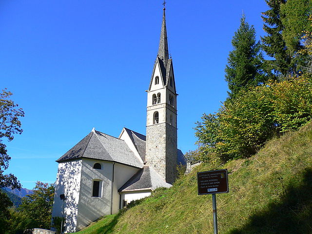
Сан-Томазо-Агордино (San Tomaso Agordino, San Tomaso Agordino)
.svg)
- коммуна Италии
 Hiking in Сан-Томазо-Агордино
San Tomaso Agordino is a picturesque village located in the Dolomites region of northern Italy. It offers a wealth of hiking opportunities for both novice and experienced hikers. Here are some highlights and tips for hiking in and around San Tomaso Agordino.
Trails and Routes
-
Valle di San Lucano: This beautiful valley offers several hiking trails that lead through lush meadows and forests, providing stunning views of the surrounding peaks. The hike can vary in difficulty, with options for easy walks and more challenging routes.
-
Sentiero dei Muretti a Secco: This trail showcases the unique dry stone walls in the area, offering insights into local agricultural practices while taking you through scenic landscapes.
-
Hiking to Lago di Castello: A rewarding trek that typically takes a few hours, leading you to a beautiful lake surrounded by mountains. It’s ideal for a day hike and offers opportunities for photography and relaxation by the water.
-
Civetta Mountain Trails: For those looking for more challenging hikes, the trails leading to the Civetta Mountain are popular, with breathtaking panorama views. Be prepared for steeper ascents and rocky paths.
When to Visit
- Summer: June to September is the best time for hiking. The weather is generally warm and dry, perfect for outdoor activities. However, always check mountain weather conditions as they can change rapidly.
- Autumn: Late September to October offers stunning fall foliage, although trails may be wet or muddy after rains.
Equipment and Safety
- Footwear: Durable hiking boots are essential for rocky and uneven terrain.
- Clothing: Dress in layers to adapt to changing temperatures; include moisture-wicking materials.
- Navigation: Ensure you have a map or GPS device, as some trails may not be well marked.
- Hydration and Snacks: Carry enough water and high-energy snacks, especially for longer hikes.
Local Wildlife and Conservation
San Tomaso Agordino is home to a diverse array of wildlife. Be respectful of nature and follow Leave No Trace principles. Wildlife sightings can include deer, chamois, and a variety of bird species.
Cultural Experiences
While hiking, take time to immerse yourself in local culture. Visit small chapels and traditional farms along the trails. The area is also known for its delicious local cuisine, so be sure to try regional dishes after your hikes.
Conclusion
Hiking in San Tomaso Agordino offers a unique blend of natural beauty, cultural experiences, and a chance to connect with the stunning landscapes of the Dolomites. Whether you're looking for a leisurely stroll or a rigorous trek, you'll find trails that suit your preferences in this beautiful region of Italy. Enjoy your hike, and remember to leave the trails as beautiful as you found them!
- Страна:

- Почтовый код: 32020
- Телефонный код: 0437
- Код автомобильного номера: BL
- Координаты: 46° 23' 0" N, 11° 59' 0" E


- GPS треки (wikiloc): [Ссылка]
- Высота над уровнем моря: 1082 м m
- Площадь: 19.18 кв.км
- Население: 626
- Веб сайт: http://www.comune.santomasoagordino.bl.it/
- Википедия русская: wiki(ru)
- Википедия английская: wiki(en)
- Википедия национальная: wiki(it)
- Хранилище Wikidata: Wikidata: Q39727
- Катеория в википедии: [Ссылка]
- код Freebase: [/m/0gk26s]
- код GeoNames: Альт: [6542189]
- код VIAF: Альт: [242351096]
- ID отношения в OpenStreetMap: [47154]
- код ISTAT: 025049
- кадастровый код Италии: I347
Граничит с регионами:

Валлада-Агордина
- коммуна Италии
Hiking in Валлада-Агордина
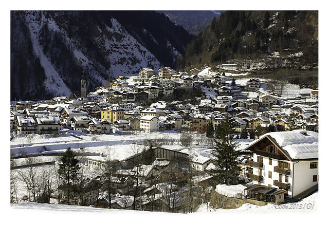
Vallada Agordina is a picturesque village located in the Dolomites region of northern Italy, making it an excellent destination for hiking enthusiasts. The surrounding area is characterized by dramatic mountain landscapes, lush valleys, and a rich variety of flora and fauna. Here's an overview of what you can expect when hiking in Vallada Agordina:...
- Страна:
- Почтовый код: 32020
- Телефонный код: 0437
- Код автомобильного номера: BL
- Координаты: 46° 22' 0" N, 11° 56' 0" E
- GPS треки (wikiloc): [Ссылка]
- Высота над уровнем моря: 1033 м m
- Площадь: 13 кв.км
- Население: 489
- Веб сайт: [Ссылка]


Аллеге
- коммуна Италии
Hiking in Аллеге
Alleghe, located in the heart of the Dolomites in northern Italy, offers stunning hiking opportunities amid breathtaking scenery. This charming town, situated on the shores of Lake Alleghe, provides access to a variety of trails suitable for hikers of all levels. Here are some highlights:...
- Страна:
- Почтовый код: 32022
- Телефонный код: 0437
- Код автомобильного номера: BL
- Координаты: 46° 24' 29" N, 12° 1' 33" E
- GPS треки (wikiloc): [Ссылка]
- Высота над уровнем моря: 1000 м m
- Площадь: 29.72 кв.км
- Население: 1194
- Веб сайт: [Ссылка]

Ченчениге-Агордино
- коммуна Италии
Hiking in Ченчениге-Агордино
Cencenighe Agordino is a picturesque village located in the Dolomites of Northern Italy, surrounded by stunning natural scenery and offering a variety of hiking opportunities. Here are some details to help you plan a hike in the area:...
- Страна:
- Почтовый код: 32020
- Телефонный код: 0437
- Код автомобильного номера: BL
- Координаты: 46° 20' 38" N, 11° 58' 28" E
- GPS треки (wikiloc): [Ссылка]
- Высота над уровнем моря: 773 м m
- Площадь: 18.13 кв.км
- Население: 1281
- Веб сайт: [Ссылка]


Рокка-Пьеторе
- коммуна Италии
Hiking in Рокка-Пьеторе
Rocca Pietore is a picturesque village located in the Dolomites region of northern Italy. It serves as an excellent base for hikers looking to explore the stunning landscapes, renowned peaks, and vibrant nature of the area. Here are some key highlights and tips for hiking in Rocca Pietore:...
- Страна:
- Почтовый код: 32020
- Телефонный код: 0437
- Код автомобильного номера: BL
- Координаты: 46° 26' 4" N, 11° 58' 38" E
- GPS треки (wikiloc): [Ссылка]
- Высота над уровнем моря: 1143 м m
- Площадь: 73.29 кв.км
- Население: 1203
- Веб сайт: [Ссылка]


Тайбон-Агордино
- коммуна Италии
Hiking in Тайбон-Агордино
Taibon Agordino is a charming village located in the Dolomites of northern Italy, within the province of Belluno. It's a fantastic area for hiking, offering a range of trails that cater to different levels of experience. Here are some highlights and tips for hiking in this beautiful region:...
- Страна:
- Почтовый код: 32027
- Телефонный код: 0437
- Код автомобильного номера: BL
- Координаты: 46° 18' 0" N, 12° 1' 0" E
- GPS треки (wikiloc): [Ссылка]
- Высота над уровнем моря: 618 м m
- Площадь: 90.06 кв.км
- Население: 1749
- Веб сайт: [Ссылка]