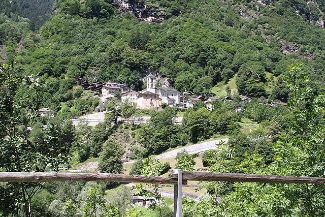
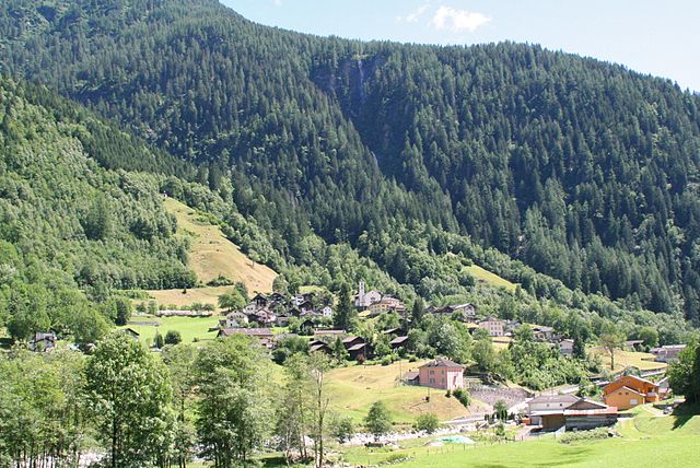
Санта-Мария-ин-Каланка (Santa Maria in Calanca, Santa Maria in Calanca)

 Hiking in Санта-Мария-ин-Каланка
Santa Maria in Calanca, located in the Calanca Valley in Switzerland, offers beautiful and accessible hiking opportunities. The region is known for its stunning landscapes, including lush valleys, dramatic mountain scenery, and a rich variety of flora and fauna.
Hiking Trails:
-
Sentiero della Valle Calanca: This scenic trail follows the Calanca River and showcases the natural beauty of the valley. It’s relatively easy and suitable for families, with opportunities to rest and enjoy the views of the surrounding mountains.
-
Hikes to the Surrounding Peaks: For more experienced hikers, trails leading to higher altitudes, such as Monte Pizzo or Pizzo di Vogorno, provide challenging routes and rewarding panoramic views of the region.
-
Local Culture Trails: Some routes explore the local culture and history, including old villages, churches, and agricultural landscapes, allowing hikers to immerse themselves in the area’s heritage.
Tips for Hiking:
- Check the Weather: Weather can change rapidly in mountainous regions, so it’s important to check forecasts before heading out.
- Gear Up: Sturdy hiking boots, appropriate clothing layers, and plenty of water and snacks are essential.
- Maps and Signage: Trails are generally well-marked, but having a map or GPS is helpful, especially for less-trafficked paths.
- Local Regulations: Respect local wildlife and follow guidelines to preserve the natural environment.
- Best Times to Hike: Late spring to early autumn are ideal for hiking, as trails are more accessible, with flowers blooming and wildlife active.
Santa Maria in Calanca and its surroundings provide a wonderful hiking experience for all levels, showcasing the beauty of the Swiss landscape along with cultural heritage. Enjoy your hike!
- Страна:

- Почтовый код: 6541
- Телефонный код: 091
- Код автомобильного номера: GR
- Координаты: 46° 15' 59" N, 9° 9' 0" E


- GPS треки (wikiloc): [Ссылка]
- Высота над уровнем моря: 955 м m
- Площадь: 9.31 кв.км
- Население: 112
- Веб сайт: http://www.santamariaic.ch/
- Википедия русская: wiki(ru)
- Википедия английская: wiki(en)
- Википедия национальная: wiki(de)
- Хранилище Wikidata: Wikidata: Q65569
- Катеория в википедии: [Ссылка]
- код Freebase: [/m/0fvmp5]
- код GeoNames: Альт: [7287051]
- код VIAF: Альт: [247174695]
- ID отношения в OpenStreetMap: [1684153]
- код GND: Альт: [4051651-9]
- идентификатор местоположения ArchINFORM: [12763]
- идентификатор HDS: [1554]
- код швейцарского муниципалитета: [3810]
Граничит с регионами:

Бузено
Hiking in Бузено
Buseno is a small, picturesque village located in the southern part of Switzerland, particularly in the canton of Graubünden. It's known for its stunning landscapes, mountainous terrain, and tranquil atmosphere, making it an excellent destination for hiking enthusiasts....
- Страна:
- Почтовый код: 6542
- Телефонный код: 091
- Код автомобильного номера: GR
- Координаты: 46° 16' 23" N, 9° 6' 26" E
- GPS треки (wikiloc): [Ссылка]
- Высота над уровнем моря: 801 м m
- Площадь: 11.15 кв.км
- Население: 83
- Веб сайт: [Ссылка]


Вердаббио
Hiking in Вердаббио
Verdabbio is a charming village located in the Italian-speaking canton of Ticino, Switzerland. Nestled in the picturesque mountains, it offers a variety of hiking opportunities that cater to different skill levels. Here are some highlights and tips for hiking in and around Verdabbio:...
- Страна:
- Почтовый код: 6538
- Телефонный код: 091
- Код автомобильного номера: GR
- Координаты: 46° 16' 25" N, 9° 12' 7" E
- GPS треки (wikiloc): [Ссылка]
- Высота над уровнем моря: 1800 м m
- Площадь: 13.13 кв.км
- Веб сайт: [Ссылка]


Кауко
Hiking in Кауко
Cauco, a beautiful and less-traveled area, offers a variety of hiking experiences characterized by stunning landscapes, diverse ecosystems, and rich cultural experiences. While specific trails can vary based on the exact location within Cauco, I can provide general information that may help you plan your hiking adventure in this region....
- Страна:
- Почтовый код: 6546
- Телефонный код: 091
- Код автомобильного номера: GR
- Координаты: 46° 20' 7" N, 9° 7' 15" E
- GPS треки (wikiloc): [Ссылка]
- Высота над уровнем моря: 1057 м m
- Площадь: 10.89 кв.км
- Веб сайт: [Ссылка]


Кастанеда
Hiking in Кастанеда
Castaneda, located in the Swiss canton of Graubünden, is a lesser-known gem for hikers seeking both beauty and tranquility. The region is characterized by stunning landscapes, including alpine meadows, picturesque valleys, and majestic mountain views. Here are a few highlights for hiking in Castaneda:...
- Страна:
- Почтовый код: 6540
- Телефонный код: 091
- Код автомобильного номера: GR
- Координаты: 46° 14' 59" N, 9° 7' 59" E
- GPS треки (wikiloc): [Ссылка]
- Высота над уровнем моря: 750 м m
- Площадь: 3.96 кв.км
- Население: 277
- Веб сайт: [Ссылка]


Гроно
Hiking in Гроно
Grono, a charming village located in the canton of Grisons (Graubünden) in Switzerland, offers stunning landscapes and a variety of hiking opportunities. The area is characterized by picturesque views of the surrounding mountains, lush valleys, and the serene atmosphere of the Swiss Alps....
- Страна:
- Почтовый код: 6537
- Телефонный код: 091
- Код автомобильного номера: GR
- Координаты: 46° 14' 54" N, 9° 8' 52" E
- GPS треки (wikiloc): [Ссылка]
- Высота над уровнем моря: 1073 м m
- Площадь: 14.81 кв.км
- Население: 1373
- Веб сайт: [Ссылка]

Сельма
Hiking in Сельма
Selma, located in the beautiful region of Graubünden in Switzerland, is surrounded by stunning alpine scenery, making it an excellent destination for hiking enthusiasts. Here’s what you can expect when hiking in and around Selma:...
- Страна:
- Почтовый код: 6545
- Телефонный код: 091
- Код автомобильного номера: GR
- Координаты: 46° 18' 59" N, 9° 7' 0" E
- GPS треки (wikiloc): [Ссылка]
- Высота над уровнем моря: 977 м m
- Площадь: 2.91 кв.км
- Веб сайт: [Ссылка]
Браджо
Hiking in Браджо
Braggio is a small village located in the beautiful region of Ticino, Switzerland, known for its stunning natural landscapes and hiking opportunities. If you're considering hiking in and around Braggio, here are some key points to keep in mind:...
- Страна:
- Почтовый код: 6544
- Телефонный код: 091
- Код автомобильного номера: GR
- Координаты: 46° 18' 11" N, 9° 7' 27" E
- GPS треки (wikiloc): [Ссылка]
- Высота над уровнем моря: 1324 м m
- Площадь: 6.91 кв.км
- Веб сайт: [Ссылка]