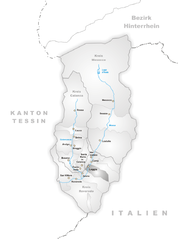
Гроно (Grono, Grono)

 Hiking in Гроно
Grono, a charming village located in the canton of Grisons (Graubünden) in Switzerland, offers stunning landscapes and a variety of hiking opportunities. The area is characterized by picturesque views of the surrounding mountains, lush valleys, and the serene atmosphere of the Swiss Alps.
Hiking Trails:
- Val Bregaglia: Nearby, this valley features beautiful trails that connect Grono with other villages and provide access to breathtaking views of the Alps.
- Parc Ela: This nature park is not far from Grono and offers numerous hiking routes through diverse ecosystems, including alpine meadows, forests, and lakes.
- Sentiero Panoramico: A scenic panoramic trail that often leads hikers to elevated viewpoints, perfect for photography and enjoying the majestic landscape.
Difficulty and Duration:
- You can find trails suitable for all levels, from easy strolls to challenging mountain hikes. Most paths are well-marked, but it's always wise to check local maps or hiking apps for detailed trail guides and difficulty ratings.
- Typical hike lengths can range from short 1-2 hour walks to full day treks, depending on the trail and your fitness level.
Best Time to Hike:
- Summer (June to September) is the most popular time for hiking in Grono, with clear paths and vibrant flora.
- Autumn also provides a stunning backdrop as the foliage changes, but be prepared for weather variations.
- Winter offers opportunities for snowshoeing and winter hiking, though trails may be more limited and require proper gear.
Tips for Hiking in Grono:
- Weather: Always check the weather forecast before your hike. Mountain weather can change rapidly.
- Gear: Proper footwear and clothing are essential. Layers are ideal for adjusting to temperature changes during your hike.
- Safety: Carry enough water, snacks, and a first aid kit. It’s advisable to inform someone about your hiking plans.
Local Culture:
As you hike around Grono, take the time to enjoy the local culture, traditional Swiss architecture, and perhaps stop by a local cheese shop or bakery to taste regional specialties.
Hiking around Grono is not just about breathtaking views; it's also an opportunity to connect with nature and experience the tranquility of the Swiss Alpine environment. Enjoy your hike!
- Страна:

- Почтовый код: 6537
- Телефонный код: 091
- Код автомобильного номера: GR
- Координаты: 46° 14' 54" N, 9° 8' 52" E


- GPS треки (wikiloc): [Ссылка]
- Высота над уровнем моря: 1073 м m
- Площадь: 14.81 кв.км
- Население: 1373
- Веб сайт: http://grono.moesano.ch
- Википедия русская: wiki(ru)
- Википедия английская: wiki(en)
- Википедия национальная: wiki(de)
- Хранилище Wikidata: Wikidata: Q66181
- Катеория в википедии: [Ссылка]
- код Freebase: [/m/026h2b7]
- код GeoNames: Альт: [7285987]
- код VIAF: Альт: [159462592]
- ID отношения в OpenStreetMap: [1684085]
- код GND: Альт: [4611754-4]
- код LCNAF: Альт: [n81151154]
- идентификатор HDS: [1560]
- код швейцарского муниципалитета: [3832]
- LIR: [1170]
Граничит с регионами:
Доссо-дель-Лиро
- коммуна Италии
Hiking in Доссо-дель-Лиро
Dosso del Liro is a beautiful destination for hiking enthusiasts, located in the northern part of Italy, close to the shores of Lake Como in the Lombardy region. The area is characterized by its picturesque landscapes, lush greenery, and stunning views of the surrounding mountains and valleys. Here are some key points to consider when planning a hiking trip to Dosso del Liro:...
- Страна:

- Почтовый код: 22015
- Телефонный код: 0344
- Код автомобильного номера: CO
- Координаты: 46° 10' 0" N, 9° 16' 0" E
- GPS треки (wikiloc): [Ссылка]
- Высота над уровнем моря: 650 м m
- Площадь: 23.49 кв.км
- Население: 262
- Веб сайт: [Ссылка]


Ровередо
Hiking in Ровередо
Roveredo is a quaint town located in the Mendrisiotto region of Ticino, Switzerland. Surrounded by stunning natural landscapes, it offers several hiking opportunities that cater to a variety of skill levels. Here are some highlights of hiking in Roveredo:...
- Страна:
- Почтовый код: 6535
- Телефонный код: 091
- Код автомобильного номера: GR
- Координаты: 46° 14' 5" N, 9° 7' 33" E
- GPS треки (wikiloc): [Ссылка]
- Высота над уровнем моря: 1239 м m
- Площадь: 38.79 кв.км
- Население: 2483
- Веб сайт: [Ссылка]

Леджа
Hiking in Леджа
Leggia, located in the picturesque region of Val Bregaglia in Switzerland, offers an array of hiking opportunities for outdoor enthusiasts. The area is known for its stunning landscapes, featuring lush forests, alpine meadows, and spectacular views of the surrounding mountains, including the Bregaglia Range and the Swiss Alps....
- Страна:
- Почтовый код: 6556
- Телефонный код: 091
- Код автомобильного номера: GR
- Координаты: 46° 15' 1" N, 9° 11' 14" E
- GPS треки (wikiloc): [Ссылка]
- Высота над уровнем моря: 1187 м m
- Площадь: 9.15 кв.км
- Веб сайт: [Ссылка]


Вердаббио
Hiking in Вердаббио
Verdabbio is a charming village located in the Italian-speaking canton of Ticino, Switzerland. Nestled in the picturesque mountains, it offers a variety of hiking opportunities that cater to different skill levels. Here are some highlights and tips for hiking in and around Verdabbio:...
- Страна:
- Почтовый код: 6538
- Телефонный код: 091
- Код автомобильного номера: GR
- Координаты: 46° 16' 25" N, 9° 12' 7" E
- GPS треки (wikiloc): [Ссылка]
- Высота над уровнем моря: 1800 м m
- Площадь: 13.13 кв.км
- Веб сайт: [Ссылка]


Санта-Мария-ин-Каланка
Hiking in Санта-Мария-ин-Каланка
Santa Maria in Calanca, located in the Calanca Valley in Switzerland, offers beautiful and accessible hiking opportunities. The region is known for its stunning landscapes, including lush valleys, dramatic mountain scenery, and a rich variety of flora and fauna....
- Страна:
- Почтовый код: 6541
- Телефонный код: 091
- Код автомобильного номера: GR
- Координаты: 46° 15' 59" N, 9° 9' 0" E
- GPS треки (wikiloc): [Ссылка]
- Высота над уровнем моря: 955 м m
- Площадь: 9.31 кв.км
- Население: 112
- Веб сайт: [Ссылка]


Кастанеда
Hiking in Кастанеда
Castaneda, located in the Swiss canton of Graubünden, is a lesser-known gem for hikers seeking both beauty and tranquility. The region is characterized by stunning landscapes, including alpine meadows, picturesque valleys, and majestic mountain views. Here are a few highlights for hiking in Castaneda:...
- Страна:
- Почтовый код: 6540
- Телефонный код: 091
- Код автомобильного номера: GR
- Координаты: 46° 14' 59" N, 9° 7' 59" E
- GPS треки (wikiloc): [Ссылка]
- Высота над уровнем моря: 750 м m
- Площадь: 3.96 кв.км
- Население: 277
- Веб сайт: [Ссылка]


Кама
- муниципалитет в Швейцарии
Hiking in Кама
Cama, located in the picturesque Graubünden region of Switzerland, offers some stunning hiking opportunities. This small village, nestled in the valley near the Albula River, is surrounded by beautiful alpine scenery, making it a great destination for both day hikes and more extended trekking adventures....
- Страна:
- Почтовый код: 6557
- Телефонный код: 091
- Код автомобильного номера: GR
- Координаты: 46° 15' 35" N, 9° 12' 27" E
- GPS треки (wikiloc): [Ссылка]
- Высота над уровнем моря: 1598 м m
- Площадь: 15.0 кв.км
- Население: 564
- Веб сайт: [Ссылка]