
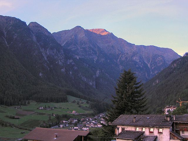
Силандро (Schlanders, Silandro)
.svg)
- коммуна в Италии
 Hiking in Силандро
Schlanders, located in the South Tyrol region of northern Italy, offers a wonderful hiking experience amid stunning alpine scenery. Surrounded by the impressive peaks of the Ortler Alps and near the beautiful Vinschgau Valley, this area is ideal for both novice and experienced hikers.
Hiking Highlights in Schlanders:
-
Scenic Trails: Schlanders features a variety of trails that cater to different skill levels. Whether you're looking for a leisurely walk or a challenging hike, you'll find trails that showcase the region's natural beauty, including lush forests, meadows, and panoramic views of the mountains.
-
The Watles Mountain: One of the most popular hiking destinations in the area is Watles, which is easily accessible from Schlanders. From the summit, hikers can enjoy breathtaking views over the surrounding valleys and peaks. There are several trails leading up to the mountain, allowing hikers to select their preferred difficulty level.
-
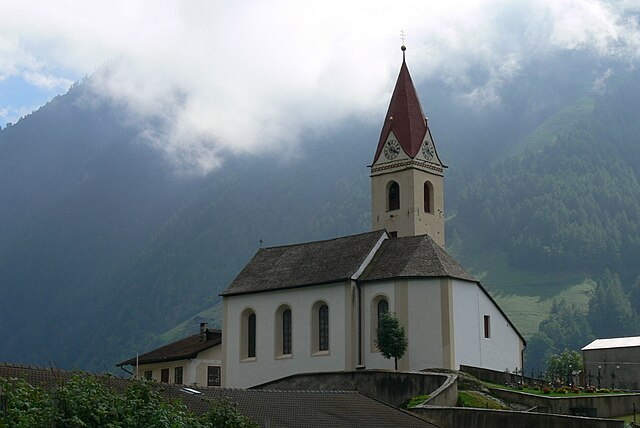
Cultural Trails: Some trails in the area also offer insights into local culture and history. You might encounter old chapels, traditional farms, and historical sites along your hike, enriching your experience in the region.
-
Wildlife and Flora: The diverse ecosystems in the area provide opportunities for wildlife observation. Keep an eye out for native animals such as chamois and various bird species, alongside a rich array of alpine flora.
-
Hiking Seasons: The best time for hiking in Schlanders is generally from late spring through early autumn (May to October). During this time, the trails are accessible, and the weather is typically clear. Summer can be particularly pleasant, while early autumn offers beautiful fall colors.
-
Guided Hikes: For those new to the area or looking for expert insight, guided hikes are often available. Local guides can provide valuable information about the landscape, flora, and fauna, as well as ensure a safe and enjoyable hiking experience.
Practical Tips:
- Map and Preparation: Be sure to carry a map or a guidebook, as some trails may not be marked as clearly as in other hiking regions. It’s also wise to check the weather forecast before heading out.
- Proper Gear: Wear sturdy hiking shoes and dress in layers, as mountain weather can change rapidly. Also, always carry enough water and snacks.
- Respect Nature: Stay on marked paths, respect local wildlife, and carry out any trash to help preserve the beauty of the area.
Overall, hiking in Schlanders is a fantastic way to enjoy the natural beauty of South Tyrol, experience local culture, and engage in physical activity in a stunning alpine setting.
- Страна:

- Почтовый код: 39028
- Телефонный код: 0473
- Код автомобильного номера: BZ
- Координаты: 46° 37' 42" N, 10° 46' 5" E


- GPS треки (wikiloc): [Ссылка]
- Высота над уровнем моря: 720 м m
- Площадь: 115.17 кв.км
- Население: 6181
- Веб сайт: http://www.comune.silandro.bz.it
- Википедия русская: wiki(ru)
- Википедия английская: wiki(en)
- Википедия национальная: wiki(it)
- Хранилище Wikidata: Wikidata: Q494313
- Галерея изображений в википедии: [Ссылка]
- Катеория в википедии: [Ссылка]
- код Freebase: [/m/067k2c]
- код GeoNames: Альт: [6535930]
- код VIAF: Альт: [123118183]
- ID отношения в OpenStreetMap: [47270]
- код GND: Альт: [4242908-0]
- код LCNAF: Альт: [n00032626]
- место в MusicBrainz: [edacfb01-97db-479a-bb39-c54123a357ac]
- код темы Quora: [Schlanders]
- код ISTAT: 021093
- кадастровый код Италии: I729
Граничит с регионами:


Лачес
- коммуна Италии
Hiking in Лачес
Latsch, located in South Tyrol, Italy, is a fantastic destination for hiking enthusiasts, offering a mix of beautiful landscapes, diverse trails, and stunning views of the surrounding Alps. Here are some highlights and tips for hiking in Latsch:...
- Страна:
- Почтовый код: 39021
- Телефонный код: 0473
- Код автомобильного номера: BZ
- Координаты: 46° 36' 59" N, 10° 51' 26" E
- GPS треки (wikiloc): [Ссылка]
- Высота над уровнем моря: 639 м m
- Площадь: 78.71 кв.км
- Население: 5216
- Веб сайт: [Ссылка]


Лаза
- коммуна Италии
Hiking in Лаза
Laas, located in the stunning South Tyrol region of northern Italy, is a small village known for its beautiful landscapes and excellent hiking opportunities. Nestled in the heart of the Alps, Laas boasts a mix of gentle trails and more challenging routes, making it suitable for hikers of all levels....
- Страна:
- Почтовый код: 39023
- Телефонный код: 0473
- Код автомобильного номера: BZ
- Координаты: 46° 37' 4" N, 10° 41' 52" E
- GPS треки (wikiloc): [Ссылка]
- Высота над уровнем моря: 868 м m
- Площадь: 110.23 кв.км
- Население: 4028
- Веб сайт: [Ссылка]


Маллес-Веноста
- коммуна Италии
Hiking in Маллес-Веноста
Mals, located in the Vinschgau Valley in South Tyrol, Italy, is a fantastic spot for hiking enthusiasts. Surrounded by stunning landscapes, picturesque villages, and a rich cultural heritage, it offers a variety of trails suitable for different skill levels....
- Страна:
- Почтовый код: 39024
- Телефонный код: 0473
- Код автомобильного номера: BZ
- Координаты: 46° 41' 16" N, 10° 32' 48" E
- GPS треки (wikiloc): [Ссылка]
- Высота над уровнем моря: 1051 м m
- Площадь: 247.43 кв.км
- Население: 5225
- Веб сайт: [Ссылка]

Мартелло
- коммуна Италии
Hiking in Мартелло
Martell is a picturesque valley located in South Tyrol, Italy, known for its breathtaking landscapes, diverse flora and fauna, and excellent hiking trails. Here are some key points to consider if you're planning a hiking trip to Martell:...
- Страна:
- Почтовый код: 39020
- Телефонный код: 0473
- Код автомобильного номера: BZ
- Координаты: 46° 33' 17" N, 10° 46' 50" E
- GPS треки (wikiloc): [Ссылка]
- Высота над уровнем моря: 1312 м m
- Площадь: 142.8 кв.км
- Население: 853
- Веб сайт: [Ссылка]

Сеналес
- коммуна в Италии
Hiking in Сеналес
Schnals, located in the South Tyrol region of Italy, is a picturesque valley that offers stunning landscapes and diverse hiking opportunities. Nestled in the Ötztal Alps, it is a popular destination for outdoor enthusiasts, especially those who enjoy alpine hiking....
- Страна:
- Почтовый код: 39020
- Телефонный код: 0473
- Код автомобильного номера: BZ
- Координаты: 46° 42' 0" N, 10° 55' 0" E
- GPS треки (wikiloc): [Ссылка]
- Высота над уровнем моря: 1317 м m
- Площадь: 209.84 кв.км
- Население: 1231
- Веб сайт: [Ссылка]