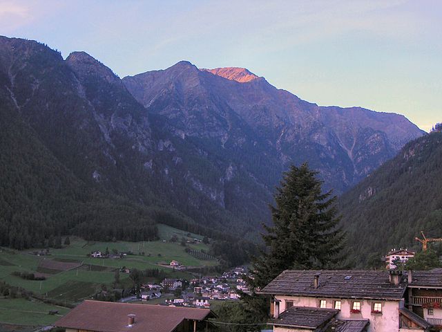
Лачес (Latsch, Laces)
.svg)
- коммуна Италии
 Hiking in Лачес
Latsch, located in South Tyrol, Italy, is a fantastic destination for hiking enthusiasts, offering a mix of beautiful landscapes, diverse trails, and stunning views of the surrounding Alps. Here are some highlights and tips for hiking in Latsch:
Trails and Routes
-
Val di Mazia: This picturesque valley features trails that vary in difficulty, making it suitable for both novice and experienced hikers. You can enjoy scenic views, alpine flowers, and possibly spot wildlife.
-
Latscher Alm: A popular hike that leads to the Latscher Alm, or Latsch Alpine Pasture, offers a moderate hike with breathtaking panoramic views. It's a great spot to relax or enjoy a meal at the local hut.
-
Kühtai Nature Park: For those looking for a more adventurous hike, the Kühtai Nature Park offers challenging trails with steep ascents and rewarding vistas.
-
The Etsch Cycle Path: For a more leisurely option, the Etsch River Cycle Path runs alongside the river, making for a beautiful hike or bike ride with scenic views of the valley and vineyards.
Best Time to Hike
- Spring and Summer (April - September): These seasons are ideal for hiking, with blooming wildflowers and generally stable weather conditions. Summer may bring higher temperatures, so it's essential to stay hydrated.
- Autumn (October): Early autumn offers beautiful fall colors and pleasant temperatures, but be aware of shorter daylight hours.
Tips for Hiking in Latsch
- Prepare for Varying Weather: Mountain weather can change quickly, so bring layers, including a waterproof jacket.
- Stay Hydrated: Carry enough water, especially on longer hikes, as some trails may have limited access to water sources.
- Local Knowledge: Consider stopping by a local visitor center for maps and additional recommendations tailored to your skill level and interests.
- Respect Nature: Stay on marked trails and avoid disturbing wildlife to help preserve the natural beauty of the area.
Additional Activities
Beyond hiking, Latsch offers opportunities for cycling, wine tasting in the nearby vineyards, and exploring local culture and cuisine. Be sure to take some time to enjoy the regional specialties, such as speck and apple strudel.
Overall, Latsch provides a wonderful outdoor experience, combining breathtaking scenery with rich cultural experiences in the heart of the Alps!
- Страна:

- Почтовый код: 39021
- Телефонный код: 0473
- Код автомобильного номера: BZ
- Координаты: 46° 36' 59" N, 10° 51' 26" E


- GPS треки (wikiloc): [Ссылка]
- Высота над уровнем моря: 639 м m
- Площадь: 78.71 кв.км
- Население: 5216
- Веб сайт: http://www.comune.laces.bz.it/system/web/default.aspx?sprache=3
- Википедия русская: wiki(ru)
- Википедия английская: wiki(en)
- Википедия национальная: wiki(it)
- Хранилище Wikidata: Wikidata: Q419816
- Катеория в википедии: [Ссылка]
- код Freebase: [/m/0g9gs8]
- код GeoNames: Альт: [6535901]
- код VIAF: Альт: [246615863]
- ID отношения в OpenStreetMap: [47262]
- код GND: Альт: [4240824-6]
- UN/LOCODE: [ITZJY]
- код ISTAT: 021037
- кадастровый код Италии: E398
Граничит с регионами:


Кастельбелло-Чиардес
- коммуна Италии
Hiking in Кастельбелло-Чиардес
Kastelbell-Tschars is a picturesque town located in South Tyrol, Italy, surrounded by stunning mountain scenery, making it an ideal destination for hiking enthusiasts. Nestled at the entrance of the Vinschgau Valley, the area offers a variety of hiking trails that cater to different skill levels, from leisurely walks to more challenging routes....
- Страна:
- Почтовый код: 39020
- Телефонный код: 0473
- Код автомобильного номера: BZ
- Координаты: 46° 37' 42" N, 10° 54' 24" E
- GPS треки (wikiloc): [Ссылка]
- Высота над уровнем моря: 587 м m
- Площадь: 53.79 кв.км
- Население: 2311
- Веб сайт: [Ссылка]

Мартелло
- коммуна Италии
Hiking in Мартелло
Martell is a picturesque valley located in South Tyrol, Italy, known for its breathtaking landscapes, diverse flora and fauna, and excellent hiking trails. Here are some key points to consider if you're planning a hiking trip to Martell:...
- Страна:
- Почтовый код: 39020
- Телефонный код: 0473
- Код автомобильного номера: BZ
- Координаты: 46° 33' 17" N, 10° 46' 50" E
- GPS треки (wikiloc): [Ссылка]
- Высота над уровнем моря: 1312 м m
- Площадь: 142.8 кв.км
- Население: 853
- Веб сайт: [Ссылка]


Ультимо
- коммуна в Италии
Hiking in Ультимо
Hiking in Ulten, which is located in South Tyrol (Südtirol), northern Italy, offers a fantastic experience for outdoor enthusiasts. The region is characterized by its stunning alpine scenery, lush valleys, and a rich diversity of flora and fauna. Here’s what you need to know about hiking in Ulten:...
- Страна:
- Почтовый код: 39016
- Телефонный код: 0473
- Код автомобильного номера: BZ
- Координаты: 46° 32' 54" N, 11° 0' 15" E
- GPS треки (wikiloc): [Ссылка]
- Высота над уровнем моря: 1190 м m
- Площадь: 208.12 кв.км
- Население: 2871
- Веб сайт: [Ссылка]


Силандро
- коммуна в Италии
Hiking in Силандро
Schlanders, located in the South Tyrol region of northern Italy, offers a wonderful hiking experience amid stunning alpine scenery. Surrounded by the impressive peaks of the Ortler Alps and near the beautiful Vinschgau Valley, this area is ideal for both novice and experienced hikers....
- Страна:
- Почтовый код: 39028
- Телефонный код: 0473
- Код автомобильного номера: BZ
- Координаты: 46° 37' 42" N, 10° 46' 5" E
- GPS треки (wikiloc): [Ссылка]
- Высота над уровнем моря: 720 м m
- Площадь: 115.17 кв.км
- Население: 6181
- Веб сайт: [Ссылка]

Сеналес
- коммуна в Италии
Hiking in Сеналес
Schnals, located in the South Tyrol region of Italy, is a picturesque valley that offers stunning landscapes and diverse hiking opportunities. Nestled in the Ötztal Alps, it is a popular destination for outdoor enthusiasts, especially those who enjoy alpine hiking....
- Страна:
- Почтовый код: 39020
- Телефонный код: 0473
- Код автомобильного номера: BZ
- Координаты: 46° 42' 0" N, 10° 55' 0" E
- GPS треки (wikiloc): [Ссылка]
- Высота над уровнем моря: 1317 м m
- Площадь: 209.84 кв.км
- Население: 1231
- Веб сайт: [Ссылка]