Зефельд-ин-Тироль (Seefeld in Tirol, Seefeld in Tirol)
 Hiking in Зефельд-ин-Тироль
Seefeld in Tirol is a stunning destination for hiking enthusiasts, nestled in the Tyrol region of Austria. Known for its beautiful landscapes, the area offers a variety of trails suitable for all levels of hikers, from beginners to advanced. Here are some highlights and tips for hiking in Seefeld:
Scenic Trails
-
Seefeld Plateau: This area features a series of easy to moderate trails that provide breathtaking views of the Alps. The terrain is gentle, making it accessible for families and those seeking a leisurely hike.
-
Gschwandtkopf: A popular hiking area with multiple trails leading to various summits, including Gschwandtkopf mountain. The panoramic views from the top are spectacular, especially in the clear mountain air.
-
Wildmoos: The Wildmoos circular hike is a delightful trek that takes you through diverse landscapes, including forests, meadows, and alpine pastures. The route usually features well-marked paths and can be enjoyed in both summer and early autumn.
-
Karwendel Nature Park: Just a short drive away, Karwendel offers more rugged terrain and challenging trails. Here you can explore higher altitudes and discover pristine nature, making it a great option for more experienced hikers.
Seasonal Highlights
-
Summer Hiking: The best time for hiking is during the summer months (June to September) when trails are accessible, and temperatures are pleasant. Wildflowers are in bloom and alpine landscapes are at their most vibrant.
-
Autumn Colors: Early autumn can be particularly beautiful, with the foliage changing color, providing a stunning backdrop for hiking.
Tips for Hikers
-
Trail Maps: Always grab a trail map at the Seefeld tourist office or download it online. It's important to understand the differing levels of difficulty for the trails.
-
Equipment: Wear proper hiking shoes with good grip, and bring necessary gear like hiking poles, sun protection, and adequate water, especially for longer hikes.
-
Stay Safe: Check the weather conditions before you head out, as weather in the mountains can change rapidly. Inform someone about your hiking plans, especially for longer or more isolated trails.
-
Guided Tours: If you're unfamiliar with the area, consider joining a guided hiking tour. Local guides can provide insights about the region's ecology and history while ensuring you navigate safely.
-
Refreshments: Many hikes include mountain huts (Almhütten) where you can take a break and sample local Tyrolean cuisine or simply enjoy a drink with a view.
Hiking in Seefeld in Tirol can be a memorable experience with its diverse trails and stunning scenery, making it a fantastic destination for nature lovers and outdoor enthusiasts.
- Страна:

- Почтовый код: 6100
- Телефонный код: 05212
- Код автомобильного номера: IL
- Координаты: 47° 19' 46" N, 11° 11' 21" E


- GPS треки (wikiloc): [Ссылка]
- Высота над уровнем моря: 1180 м m
- Площадь: 17.4 кв.км
- Население: 3440
- Веб сайт: http://www.gemeinde-seefeld.eu/
- Википедия русская: wiki(ru)
- Википедия английская: wiki(en)
- Википедия национальная: wiki(de)
- Хранилище Wikidata: Wikidata: Q660035
- Галерея изображений в википедии: [Ссылка]
- Катеория в википедии: [Ссылка]
- код Freebase: [/m/07mpdd]
- код GeoNames: Альт: [2765278]
- код VIAF: Альт: [244080257]
- идентификатор местоположения ArchINFORM: [8757]
- код LCNAF: Альт: [n83023278]
- WOEID: [12675569]
- код места в Facebook: [113624721983951]
- код австрийского муниципалитета: [70351]
Граничит с регионами:

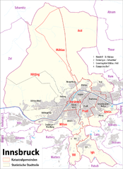
Инсбрук
- город, административный центр федеральной земли Тироль, Австрия
Hiking in Инсбрук
Innsbruck, located in the heart of the Austrian Alps, is a fantastic destination for hikers of all skill levels. Surrounded by stunning mountain ranges, including the Nordkette, Patscherkofel, and Axamer Lizum, there are numerous trails offering breathtaking views, diverse landscapes, and varying degrees of difficulty....
- Страна:
- Почтовый код: 6080; 6010–6040; 6020
- Телефонный код: 0512
- Код автомобильного номера: I
- Координаты: 47° 16' 0" N, 11° 23' 0" E
- GPS треки (wikiloc): [Ссылка]
- Высота над уровнем моря: 574 м m
- Площадь: 105 кв.км
- Население: 130894
- Веб сайт: [Ссылка]
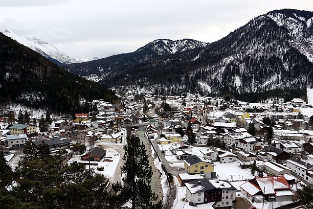
Шарниц
Hiking in Шарниц
Scharnitz is a picturesque village located at the border between Germany and Austria, serving as a perfect starting point for various hiking adventures in the Tyrolean Alps. The area is known for its stunning natural beauty, diverse trails, and opportunities for outdoor activities....
- Страна:
- Почтовый код: 6108
- Телефонный код: 05213
- Код автомобильного номера: IL
- Координаты: 47° 23' 18" N, 11° 15' 54" E
- GPS треки (wikiloc): [Ссылка]
- Высота над уровнем моря: 964 м m
- Площадь: 158.77 кв.км
- Население: 1403
- Веб сайт: [Ссылка]