Шарниц (Scharnitz, Scharnitz)
 Hiking in Шарниц
Scharnitz is a picturesque village located at the border between Germany and Austria, serving as a perfect starting point for various hiking adventures in the Tyrolean Alps. The area is known for its stunning natural beauty, diverse trails, and opportunities for outdoor activities.
Key Hiking Trails in Scharnitz:
-
Karwendel National Park:
- The trails within the park offer breathtaking views of rugged mountains, dense forests, and tranquil alpine lakes. Some popular routes include the Gramai-Alm hike and the trails leading to the peaks of the Karwendel range.
-
Isar Trail:
- This scenic walk follows the Isar River and offers a gentle and family-friendly hike that takes you through beautiful landscapes, with opportunities to spot wildlife and enjoy the calming sounds of the flowing river.
-
Hochland Rundweg:
- A loop trail that offers panoramic views and is suitable for a full-day hike. It provides a good mix of moderate terrain with some steep sections.
-
Seekarkopf:
- This hike leads you to one of the local peaks, where you'll be rewarded with stunning vistas of the surrounding mountains and valleys. The trail is moderately challenging, making it ideal for those looking for a bit more adventure.
Tips for Hiking in Scharnitz:
- Seasonal Considerations: Summer and early autumn are usually the best times for hiking, as trails are clear of snow. However, always check the weather conditions before heading out, as mountain weather can change rapidly.
- Trail Conditions: It’s advisable to check local resources or visitor centers for current trail conditions and any closures.
- Safety: Carry sufficient water, wear appropriate footwear, and have a map or GPS device. Let someone know your hiking plan, especially if you are tackling longer or less crowded routes.
- Alpine Culture: Take some time to explore the culture of the region through its traditional Alpine huts (Almhütten), where you can taste local food and experience Tyrolean hospitality.
Accessibility:
Scharnitz is easily accessible by car or public transport. The village itself provides a good base for various outdoor activities, with ample accommodation options for hikers.
Whether you're a seasoned hiker or a beginner, Scharnitz and its surrounding areas have something to offer everyone. Enjoy the stunning alpine scenery, rich wildlife, and the tranquility that comes with hiking in one of Austria's renowned natural parks!
- Страна:

- Почтовый код: 6108
- Телефонный код: 05213
- Код автомобильного номера: IL
- Координаты: 47° 23' 18" N, 11° 15' 54" E


- GPS треки (wikiloc): [Ссылка]
- Высота над уровнем моря: 964 м m
- Площадь: 158.77 кв.км
- Население: 1403
- Веб сайт: http://www.scharnitz.tirol.gv.at/
- Википедия русская: wiki(ru)
- Википедия английская: wiki(en)
- Википедия национальная: wiki(de)
- Хранилище Wikidata: Wikidata: Q664826
- Катеория в википедии: [Ссылка]
- код Freebase: [/m/02w05pk]
- код GeoNames: Альт: [2766140]
- код VIAF: Альт: [128987023]
- код GND: Альт: [4566566-7]
- код LCNAF: Альт: [n78084609]
- код австрийского муниципалитета: [70348]
- код Цифрового атласа Римской империи: [102]
Граничит с регионами:


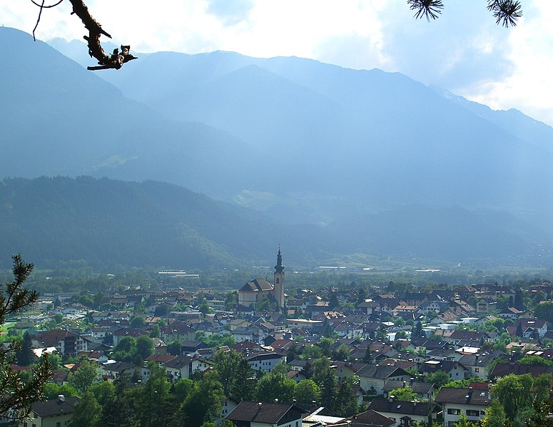
Миттенвальд
Hiking in Миттенвальд
Mittenwald, located in Bavaria, Germany, is a beautiful destination for hiking enthusiasts. Nestled in the Karwendel Mountain range, it offers a variety of trails that cater to all levels of hikers, from beginners to seasoned adventurers. Here are some highlights about hiking in the area:...
- Страна:

- Почтовый код: 82481
- Телефонный код: 08823
- Код автомобильного номера: GAP
- Координаты: 47° 25' 0" N, 11° 15' 0" E
- GPS треки (wikiloc): [Ссылка]
- Высота над уровнем моря: 923 м m
- Площадь: 132.85 кв.км
- Население: 7387
- Веб сайт: [Ссылка]

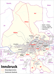
Инсбрук
- город, административный центр федеральной земли Тироль, Австрия
Hiking in Инсбрук
Innsbruck, located in the heart of the Austrian Alps, is a fantastic destination for hikers of all skill levels. Surrounded by stunning mountain ranges, including the Nordkette, Patscherkofel, and Axamer Lizum, there are numerous trails offering breathtaking views, diverse landscapes, and varying degrees of difficulty....
- Страна:
- Почтовый код: 6080; 6010–6040; 6020
- Телефонный код: 0512
- Код автомобильного номера: I
- Координаты: 47° 16' 0" N, 11° 23' 0" E
- GPS треки (wikiloc): [Ссылка]
- Высота над уровнем моря: 574 м m
- Площадь: 105 кв.км
- Население: 130894
- Веб сайт: [Ссылка]


Фомп
Hiking in Фомп
Vomp, located in the Tyrol region of Austria, is a charming village that serves as a gateway to stunning hiking experiences in the surrounding mountains. Here are some key points about hiking in and around Vomp:...
- Страна:
- Код автомобильного номера: SZ
- Координаты: 47° 20' 32" N, 11° 41' 0" E
- GPS треки (wikiloc): [Ссылка]
- Высота над уровнем моря: 563 м m
- Площадь: 182.61 кв.км
- Население: 5146
- Веб сайт: [Ссылка]
Цирль
Hiking in Цирль
Zirl, located in Tyrol, Austria, is a charming village that serves as a great base for hikers looking to explore the stunning landscapes of the region. Here are some highlights and tips for hiking in and around Zirl:...
- Страна:
- Почтовый код: 6170
- Телефонный код: 05238
- Код автомобильного номера: IL
- Координаты: 47° 16' 24" N, 11° 14' 29" E
- GPS треки (wikiloc): [Ссылка]
- Высота над уровнем моря: 622 м m
- Площадь: 57.24 кв.км
- Население: 8162
- Веб сайт: [Ссылка]


Абзам
Hiking in Абзам
Absam, located in Tyrol, Austria, is a beautiful area surrounded by the stunning scenery of the Alps, making it a fantastic destination for hiking enthusiasts. Here are a few key points about hiking in Absam:...
- Страна:
- Почтовый код: 6067
- Телефонный код: 05223
- Код автомобильного номера: IL
- Координаты: 47° 17' 0" N, 11° 30' 0" E
- GPS треки (wikiloc): [Ссылка]
- Высота над уровнем моря: 632 м m
- Площадь: 51.92 кв.км
- Население: 7112
- Веб сайт: [Ссылка]

Зефельд-ин-Тироль
Hiking in Зефельд-ин-Тироль
Seefeld in Tirol is a stunning destination for hiking enthusiasts, nestled in the Tyrol region of Austria. Known for its beautiful landscapes, the area offers a variety of trails suitable for all levels of hikers, from beginners to advanced. Here are some highlights and tips for hiking in Seefeld:...
- Страна:
- Почтовый код: 6100
- Телефонный код: 05212
- Код автомобильного номера: IL
- Координаты: 47° 19' 46" N, 11° 11' 21" E
- GPS треки (wikiloc): [Ссылка]
- Высота над уровнем моря: 1180 м m
- Площадь: 17.4 кв.км
- Население: 3440
- Веб сайт: [Ссылка]

Лойташ
Hiking in Лойташ
Leutasch is a stunning valley located in the Tyrol region of Austria, near the border with Germany. It's well-known for its picturesque landscapes, breath-taking mountain views, and a variety of hiking trails suitable for all experience levels. Here’s what you need to know about hiking in Leutasch:...
- Страна:
- Почтовый код: 6105
- Телефонный код: 05214
- Код автомобильного номера: IL
- Координаты: 47° 22' 0" N, 11° 9' 0" E
- GPS треки (wikiloc): [Ссылка]
- Высота над уровнем моря: 1136 м m
- Площадь: 103.1 кв.км
- Население: 2380
- Веб сайт: [Ссылка]