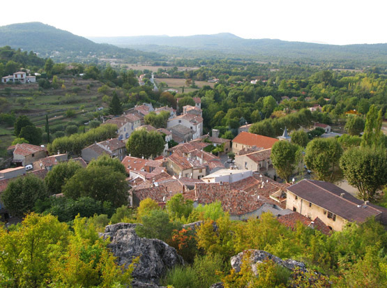
Синь (Signes, Signes)

- коммуна департамента Вар,Франция
 Hiking in Синь
Signes is a charming village located in the Var department of the Provence-Alpes-Côte d'Azur region in southeastern France. It offers a variety of hiking opportunities, showcasing the region's stunning natural landscapes, rich flora, and diverse fauna.
Hiking Trails in Signes
-
Montagne de la Sainte-Baume: This nearby mountain range provides several trails with different levels of difficulty. The trails often lead you through chestnut forests and past beautiful viewpoints. The ascent can be strenuous, but the views from the top are rewarding.
-
Gorges de la République: A short hike leads you to these picturesque gorges. The trails here are generally easier, making it a great option for families. The scenery along the way, including the unique rock formations and the flowing water, creates a beautiful backdrop.
-
Le Circuit des Pichouliers: This moderate loop trail offers a blend of natural beauty and historical significance. Hikers can enjoy the local flora and fauna while also learning about the area's cultural heritage.
Tips for Hiking in Signes
- Stay Hydrated: Bring plenty of water, as some trails may not have accessible water sources.
- Wear Appropriate Footwear: Good hiking shoes are essential, especially on rugged trails.
- Check the Weather: Conditions can change quickly, so it's wise to check the forecast before heading out.
- Bring a Map or GPS: While many trails are well-marked, having a map or GPS can help you stay oriented, especially in less-traveled areas.
- Wildlife: Keep an eye out for local wildlife, including birds and other animals, while staying a respectful distance away.
Best Time to Visit
The best time for hiking in the Signes area is typically during spring (April to June) and fall (September to October) when temperatures are mild, and the scenery is particularly beautiful with blooming flowers or fall foliage.
Local Attractions
In addition to hiking, Signes is home to several local attractions, such as the village center, with its traditional Provencal architecture, cafes, and shops. After a day of hiking, consider sampling local cuisine or visiting nearby vineyards for a taste of regional wines.
In summary, Signes offers wonderful hiking opportunities for both beginners and experienced hikers, with beautiful landscapes and a chance to experience the tranquility of Provence. Enjoy your time outdoors!
- Страна:

- Почтовый код: 83870
- Координаты: 43° 17' 29" N, 5° 51' 46" E


- GPS треки (wikiloc): [Ссылка]
- Площадь: 133.1 кв.км
- Население: 2779
- Википедия русская: wiki(ru)
- Википедия английская: wiki(en)
- Википедия национальная: wiki(fr)
- Хранилище Wikidata: Wikidata: Q816094
- Катеория в википедии: [Ссылка]
- код Freebase: [/m/03qhfmt]
- код GeoNames: Альт: [6445070]
- номер SIREN: [218301273]
- код BNF: [15277954r]
- код VIAF: Альт: [145895797]
- код тезауруса PACTOLS: [pcrt5iyapsZGYg]
- WOEID: [622129]
- код в энциклопедии «Британника онлайн»: [place/Signes]
- код муниципалитета INSEE: 83127
Граничит с регионами:

Мазог
- коммуна во Франции
Hiking in Мазог
Mazaugues is a charming village located in the Var department of the Provence-Alpes-Côte d'Azur region in southeastern France. It is surrounded by beautiful landscapes, making it a great destination for hiking enthusiasts. Here are some highlights about hiking in and around Mazaugues:...
- Страна:
- Почтовый код: 83136
- Координаты: 43° 20' 51" N, 5° 55' 19" E
- GPS треки (wikiloc): [Ссылка]
- Площадь: 53.79 кв.км
- Население: 887

План-д’Опс-Сент-Бом
- коммуна во Франции
Hiking in План-д’Опс-Сент-Бом
Plan-d'Aups-Sainte-Baume is a beautiful destination for hiking enthusiasts, located in the Var department of the Provence-Alpes-Côte d'Azur region of southeastern France. Nestled at the foot of the Sainte-Baume mountain range, this area offers a range of trails that vary in difficulty and scenery....
- Страна:
- Почтовый код: 83640
- Координаты: 43° 19' 48" N, 5° 43' 3" E
- GPS треки (wikiloc): [Ссылка]
- Высота над уровнем моря: 700 м m
- Площадь: 24.91 кв.км
- Население: 2067


Эвенос
- коммуна во Франции
- Страна:
- Почтовый код: 83330
- Координаты: 43° 10' 12" N, 5° 49' 48" E
- GPS треки (wikiloc): [Ссылка]
- Площадь: 41.95 кв.км
- Население: 2246
- Веб сайт: [Ссылка]


Кюж-ле-Пен
- коммуна во Франции
- Страна:
- Почтовый код: 13780
- Координаты: 43° 16' 35" N, 5° 42' 2" E
- GPS треки (wikiloc): [Ссылка]
- Площадь: 38.81 кв.км
- Население: 5007
- Веб сайт: [Ссылка]


Меун-ле-Монтриё
- коммуна во Франции
Hiking in Меун-ле-Монтриё
Méounes-lès-Montrieux is a charming village located in the Var department of the Provence-Alpes-Côte d'Azur region in southeastern France. It is surrounded by beautiful landscapes, making it a great destination for hiking enthusiasts. Here are some important aspects to consider when hiking in and around Méounes-lès-Montrieux:...
- Страна:
- Почтовый код: 83136
- Координаты: 43° 16' 52" N, 5° 58' 12" E
- GPS треки (wikiloc): [Ссылка]
- Площадь: 40.92 кв.км
- Население: 2152

Ле-Боссе
- коммуна во Франции
- Страна:
- Почтовый код: 83330
- Координаты: 43° 11' 54" N, 5° 48' 10" E
- GPS треки (wikiloc): [Ссылка]
- Площадь: 35.95 кв.км
- Население: 9488
- Веб сайт: [Ссылка]


Сольес-Тука
- коммуна во Франции
Hiking in Сольес-Тука
Solliès-Toucas is a picturesque village located in the Var department of the Provence-Alpes-Côte d'Azur region in southeastern France. Nestled in a valley surrounded by lush hills and vineyards, it offers a variety of hiking opportunities for both novice and experienced hikers....
- Страна:
- Почтовый код: 83210
- Координаты: 43° 12' 20" N, 6° 1' 30" E
- GPS треки (wikiloc): [Ссылка]
- Площадь: 30.09 кв.км
- Население: 5756
- Веб сайт: [Ссылка]


Рибу
- коммуна во Франции
Hiking in Рибу
Riboux is a picturesque area located in the Provence-Alpes-Côte d'Azur region of France, known for its stunning natural landscapes and diverse hiking trails. Here are some key points to consider when hiking in Riboux:...
- Страна:
- Почтовый код: 13780
- Координаты: 43° 18' 12" N, 5° 45' 23" E
- GPS треки (wikiloc): [Ссылка]
- Площадь: 13.48 кв.км
- Население: 42


Ле-Кастелле
- коммуна департамента Вар, Франция
- Страна:
- Почтовый код: 83330
- Координаты: 43° 12' 10" N, 5° 46' 36" E
- GPS треки (wikiloc): [Ссылка]
- Высота над уровнем моря: 300 м m
- Площадь: 44.77 кв.км
- Население: 3947
- Веб сайт: [Ссылка]


Ла-Рокбрюсан
- коммуна во Франции
Hiking in Ла-Рокбрюсан
La Roquebrussanne, a charming village located in the Var department of the Provence-Alpes-Côte d'Azur region in southeastern France, is surrounded by picturesque landscapes that are perfect for hiking enthusiasts. The area features a variety of trails that cater to different skill levels, offering opportunities to explore beautiful natural scenery, including forests, hills, and vineyards....
- Страна:
- Почтовый код: 83136
- Координаты: 43° 20' 25" N, 5° 58' 35" E
- GPS треки (wikiloc): [Ссылка]
- Площадь: 37.05 кв.км
- Население: 2540