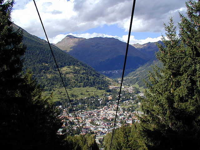
Сондало (Sondalo, Sondalo)
.svg)
- коммуна Италии
 Hiking in Сондало
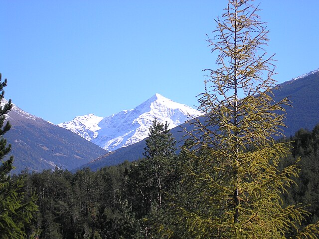
Sondalo is a charming town located in the Valtellina Valley in northern Italy, surrounded by stunning natural landscapes that make it an excellent destination for hiking enthusiasts. The area is characterized by its dramatic mountains, lush forests, and rich biodiversity.
Hiking Opportunities
-
Sentiero dei Fiori: This trail offers spectacular views of the surrounding mountains and valleys. It is well-marked and suitable for hikers of various skill levels. The trail is especially beautiful during spring and summer when wildflowers blanket the meadows.
-
Parco Nazionale dello Stelvio: Just a short drive from Sondalo, this national park is one of the largest protected areas in Italy. It offers a wide range of hiking trails, from easy walks to challenging alpine routes. The park is home to diverse wildlife, including ibex, chamois, and various bird species.
-
Monte Disgrazia: For more experienced hikers, tackling Monte Disgrazia can be a rewarding challenge. The hike provides breathtaking vistas and is a great way to experience the rugged beauty of the region.
-
Valle di Rezzalo: This valley offers several lesser-known trails that are perfect for those looking to escape the crowds. The hike through Valle di Rezzalo typically leads to serene landscapes, waterfalls, and tranquil alpine lakes.
Tips for Hiking in Sondalo
-
Best Time to Go: The ideal time for hiking in Sondalo is between late spring and early autumn when the weather is milder and the trails are accessible. Always check the weather forecast before heading out.
-
Gear: Wear sturdy hiking boots, comfortable clothing, and bring weather-appropriate gear. A good backpack with water, snacks, a map, and a first-aid kit is essential.
-
Trail Maps and Guidance: Carry a map or GPS device, as some trails may not be well-marked. Consider hiring a local guide for an enriching experience and insider knowledge on the area.
-
Respect Nature: Follow the principles of Leave No Trace. Stay on marked trails, pack out all trash, and respect wildlife.
Local Culture and Amenities
Sondalo offers a glimpse into the local culture, with charming architecture and delicious traditional cuisine. After a day of hiking, you can enjoy local dishes like pizzoccheri (a type of buckwheat pasta) and local cheeses.
In summary, Sondalo provides a fantastic base for exploring the beautiful hiking trails of the Valtellina area, with options for all skill levels and breathtaking natural scenery to enjoy. Always plan ahead to ensure a safe and enjoyable hiking experience!
- Страна:

- Почтовый код: 23035
- Телефонный код: 0342
- Код автомобильного номера: SO
- Координаты: 46° 20' 0" N, 10° 20' 0" E


- GPS треки (wikiloc): [Ссылка]
- Высота над уровнем моря: 900 м m
- Площадь: 95.45 кв.км
- Население: 4114
- Веб сайт: http://www.comune.sondalo.so.it/
- Википедия русская: wiki(ru)
- Википедия английская: wiki(en)
- Википедия национальная: wiki(it)
- Хранилище Wikidata: Wikidata: Q40165
- Катеория в википедии: [Ссылка]
- код Freebase: [/m/0gj3s4]
- код GeoNames: Альт: [6537105]
- код VIAF: Альт: [234809241]
- ID отношения в OpenStreetMap: [47132]
- WOEID: [724326]
- UN/LOCODE: [ITSL7]
- код ISTAT: 014060
- кадастровый код Италии: I828
Граничит с регионами:
Понте-ди-Леньо
- коммуна Италии
Hiking in Понте-ди-Леньо
Ponte di Legno is a beautiful alpine resort located in the Lombardy region of northern Italy, nestled within the stunning landscape of the Adamello-Presanella Natural Park. This area is renowned for its breathtaking mountain scenery, diverse flora and fauna, and a variety of hiking trails suitable for all levels of hikers....
- Страна:
- Почтовый код: 25056
- Телефонный код: 0364
- Код автомобильного номера: BS
- Координаты: 46° 15' 34" N, 10° 30' 34" E
- GPS треки (wikiloc): [Ссылка]
- Высота над уровнем моря: 1258 м m
- Площадь: 100.43 кв.км
- Население: 1730
- Веб сайт: [Ссылка]

Вальфурва
- коммуна Италии
Hiking in Вальфурва
Valfurva, located in the Lombardy region of northern Italy, is a beautiful destination for hiking enthusiasts, offering stunning alpine scenery and a variety of trails suitable for different skill levels. The area is part of the Stelvio National Park, which is known for its diverse landscapes, including mountains, forests, and meadows....
- Страна:
- Почтовый код: 23030
- Телефонный код: 0342
- Код автомобильного номера: SO
- Координаты: 46° 27' 0" N, 10° 25' 0" E
- GPS треки (wikiloc): [Ссылка]
- Высота над уровнем моря: 1800 м m
- Площадь: 215.02 кв.км
- Население: 2581
- Веб сайт: [Ссылка]
Вальдизотто
- коммуна Италии
Hiking in Вальдизотто
Valdisotto is a beautiful destination located in the Valtellina region of Lombardy, Italy, known for its stunning landscapes, rich natural heritage, and excellent hiking opportunities. Nestled in the Alps, Valdisotto offers a range of trails that cater to hikers of all skill levels, from easy walks to challenging alpine routes....
- Страна:
- Почтовый код: 23030
- Телефонный код: 0342
- Код автомобильного номера: SO
- Координаты: 46° 25' 0" N, 10° 21' 0" E
- GPS треки (wikiloc): [Ссылка]
- Высота над уровнем моря: 1141 м m
- Площадь: 89.57 кв.км
- Население: 3601
- Веб сайт: [Ссылка]


Грозьо
- коммуна Италии
Hiking in Грозьо
Grosio, located in the Valtellina valley of northern Italy, is a wonderful destination for hiking enthusiasts. Surrounded by the stunning Rhaetian Alps, the area offers a variety of trails that cater to different skill levels, from casual walkers to experienced hikers....
- Страна:
- Почтовый код: 23033
- Телефонный код: 0342
- Код автомобильного номера: SO
- Координаты: 46° 18' 0" N, 10° 17' 0" E
- GPS треки (wikiloc): [Ссылка]
- Высота над уровнем моря: 656 м m
- Площадь: 126.92 кв.км
- Население: 4431
- Веб сайт: [Ссылка]

Вецца-д'Ольо
- коммуна Италии
Hiking in Вецца-д'Ольо
Vezza d'Oglio is a charming town located in the Camonica Valley in the Lombardy region of northern Italy. It serves as a gateway to numerous hiking opportunities in the surrounding areas. Here are some highlights and tips for hiking around Vezza d'Oglio:...
- Страна:
- Почтовый код: 25059
- Телефонный код: 0364
- Код автомобильного номера: BS
- Координаты: 46° 14' 20" N, 10° 23' 53" E
- GPS треки (wikiloc): [Ссылка]
- Высота над уровнем моря: 1080 м m
- Площадь: 54.15 кв.км
- Население: 1443
- Веб сайт: [Ссылка]