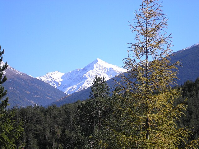
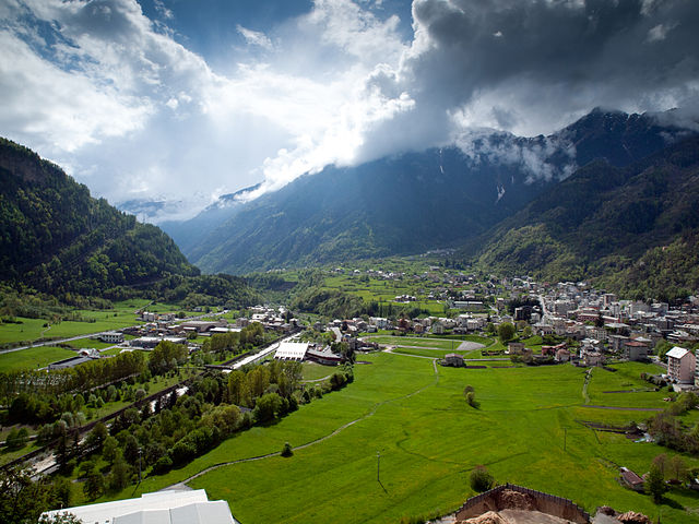
Вальдизотто (Valdisotto, Valdisotto)
.svg)
- коммуна Италии
 Hiking in Вальдизотто
Valdisotto is a beautiful destination located in the Valtellina region of Lombardy, Italy, known for its stunning landscapes, rich natural heritage, and excellent hiking opportunities. Nestled in the Alps, Valdisotto offers a range of trails that cater to hikers of all skill levels, from easy walks to challenging alpine routes.
Highlights of Hiking in Valdisotto:
-
Scenic Trails: The area features a variety of trails that showcase the breathtaking scenery of the surrounding mountains, valleys, and forests. You can expect to see picturesque views of the Alps, lush meadows, and charming traditional villages.
-
Variety of Difficulty Levels: Whether you are a beginner looking for a leisurely stroll or an experienced hiker seeking a challenging trek, Valdisotto has options for everyone. Popular trails include both short, accessible paths and more demanding routes that lead to higher altitudes.
-
Local Flora and Fauna: As you hike, you'll have the opportunity to encounter diverse wildlife and an array of alpine flowers. The region is home to various species, including chamois, marmots, and a variety of birds.
-
Cultural Heritage: Many trails pass through or near charming villages, giving hikers a chance to experience local culture, traditional architecture, and regional cuisine. Stop by a local trattoria to sample Lombardy's culinary delights.
-
Nearby Attractions: Valdisotto is in proximity to several other hiking regions, including the Stelvio National Park and the Bormio area, which can be added to your hiking itinerary for even more exploration.
Recommended Hikes in Valdisotto:
- Sentiero del Sole: A delightful trail that offers panoramic views and is suitable for all levels. It's often recommended for families.
- Rifugio Oga: A moderate hike that takes you to a mountain hut, where you can rest and enjoy refreshments.
- Cima Piazzi: For more experienced hikers, this trail leads to a higher elevation with stunning views of the surrounding peaks.
Safety and Preparation:
- Weather Conditions: Always check the weather forecast before heading out, as conditions can change rapidly in the mountains.
- Gear: Wear appropriate footwear (hiking boots), and consider bringing trekking poles, water, snacks, and a first-aid kit.
- Altitude Considerations: If you are hiking at higher elevations, be aware of altitude sickness symptoms and hydrate properly.
- Map and Navigation: Familiarize yourself with the trail maps and route markers to ensure you stay on track.
In summary, hiking in Valdisotto offers a wonderfully varied and immersive experience, perfect for anyone looking to explore the natural beauty of the Italian Alps. Enjoy your adventure!
- Страна:

- Почтовый код: 23030
- Телефонный код: 0342
- Код автомобильного номера: SO
- Координаты: 46° 25' 0" N, 10° 21' 0" E


- GPS треки (wikiloc): [Ссылка]
- Высота над уровнем моря: 1141 м m
- Площадь: 89.57 кв.км
- Население: 3601
- Веб сайт: http://www.comune.valdisotto.so.it/
- Википедия русская: wiki(ru)
- Википедия английская: wiki(en)
- Википедия национальная: wiki(it)
- Хранилище Wikidata: Wikidata: Q40277
- Катеория в википедии: [Ссылка]
- код Freebase: [/m/0gj41l]
- код GeoNames: Альт: [6542766]
- код VIAF: Альт: [145312613]
- ID отношения в OpenStreetMap: [47169]
- код ISTAT: 014072
- кадастровый код Италии: L563
Граничит с регионами:

Вальфурва
- коммуна Италии
Hiking in Вальфурва
Valfurva, located in the Lombardy region of northern Italy, is a beautiful destination for hiking enthusiasts, offering stunning alpine scenery and a variety of trails suitable for different skill levels. The area is part of the Stelvio National Park, which is known for its diverse landscapes, including mountains, forests, and meadows....
- Страна:
- Почтовый код: 23030
- Телефонный код: 0342
- Код автомобильного номера: SO
- Координаты: 46° 27' 0" N, 10° 25' 0" E
- GPS треки (wikiloc): [Ссылка]
- Высота над уровнем моря: 1800 м m
- Площадь: 215.02 кв.км
- Население: 2581
- Веб сайт: [Ссылка]


Вальдидентро
- коммуна Италии
Hiking in Вальдидентро
Valdidentro is a beautiful valley located in the Lombardy region of northern Italy, within the larger Valtellina area. It's an excellent spot for hiking enthusiasts, offering a variety of trails that cater to different experience levels, stunning scenery, and opportunities to explore the rich natural and cultural heritage of the region....
- Страна:
- Почтовый код: 23038
- Телефонный код: 0342
- Код автомобильного номера: SO
- Координаты: 46° 29' 0" N, 10° 18' 0" E
- GPS треки (wikiloc): [Ссылка]
- Высота над уровнем моря: 1345 м m
- Площадь: 226.73 кв.км
- Население: 4131
- Веб сайт: [Ссылка]

Сондало
- коммуна Италии
Hiking in Сондало
Sondalo is a charming town located in the Valtellina Valley in northern Italy, surrounded by stunning natural landscapes that make it an excellent destination for hiking enthusiasts. The area is characterized by its dramatic mountains, lush forests, and rich biodiversity....
- Страна:
- Почтовый код: 23035
- Телефонный код: 0342
- Код автомобильного номера: SO
- Координаты: 46° 20' 0" N, 10° 20' 0" E
- GPS треки (wikiloc): [Ссылка]
- Высота над уровнем моря: 900 м m
- Площадь: 95.45 кв.км
- Население: 4114
- Веб сайт: [Ссылка]


Бормио
- коммуна Италии
Hiking in Бормио
Bormio is a beautiful town located in the Italian Alps, specifically within the Lombardy region. It's well known for its stunning landscapes, rich history, and access to a variety of outdoor activities, including hiking. Here’s an overview of what to expect when hiking in Bormio:...
- Страна:
- Почтовый код: 23032
- Телефонный код: 0342
- Код автомобильного номера: SO
- Координаты: 46° 28' 0" N, 10° 22' 0" E
- GPS треки (wikiloc): [Ссылка]
- Высота над уровнем моря: 1225 м m
- Площадь: 41.44 кв.км
- Население: 4194
- Веб сайт: [Ссылка]


Грозьо
- коммуна Италии
Hiking in Грозьо
Grosio, located in the Valtellina valley of northern Italy, is a wonderful destination for hiking enthusiasts. Surrounded by the stunning Rhaetian Alps, the area offers a variety of trails that cater to different skill levels, from casual walkers to experienced hikers....
- Страна:
- Почтовый код: 23033
- Телефонный код: 0342
- Код автомобильного номера: SO
- Координаты: 46° 18' 0" N, 10° 17' 0" E
- GPS треки (wikiloc): [Ссылка]
- Высота над уровнем моря: 656 м m
- Площадь: 126.92 кв.км
- Население: 4431
- Веб сайт: [Ссылка]