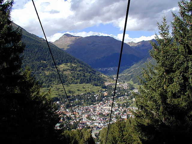
Вальфурва (Valfurva, Valfurva)
.svg)
- коммуна Италии
 Hiking in Вальфурва
Valfurva, located in the Lombardy region of northern Italy, is a beautiful destination for hiking enthusiasts, offering stunning alpine scenery and a variety of trails suitable for different skill levels. The area is part of the Stelvio National Park, which is known for its diverse landscapes, including mountains, forests, and meadows.
Key Features of Hiking in Valfurva:
-
Diverse Trails: There are numerous hiking trails ranging from easy walks to challenging mountain routes. This allows hikers of all experience levels to find suitable paths.
-
Stunning Scenery: The hikes offer breathtaking views of the Ortles-Cevedale massif, glaciers, and lush valleys. You can expect to see beautiful flora and fauna, particularly during the warmer months.
-
Popular Trails:
- Sentiero dei Fiori (Path of Flowers): This easier trail is perfect for families and offers spectacular views and diverse plant life.
- Rifugio Forni: A moderately challenging hike that leads to the Forni Hut, offering a chance to enjoy traditional alpine cuisine with spectacular views of the surrounding mountains.
- Pizzo Tresero: For experienced hikers, climbing this peak provides a rewarding sense of achievement along with panoramic views.
-
Wildlife: The area is home to various wildlife species, including chamois, marmots, and numerous bird species. This makes it a great place for nature lovers and photographers.
-
Cultural Experiences: Valfurva is rich in local culture, with opportunities to experience traditional traditions, architecture, and cuisine.
-
Best Time to Visit: The ideal hiking season runs from late spring through early autumn (May to October) when the trails are generally clear of snow and the weather is more favorable.
-
Preparation: As with any hiking adventure, it’s important to be well-prepared. Wear appropriate footwear, bring enough water, pack snacks, and be informed about the trail conditions. Additionally, consider the weather forecast, as conditions can change rapidly in the mountains.
-
Local Facilities: There are various accommodations and dining options in Valfurva, from hotels to mountain huts, where you can rest and refuel after a day of hiking.
Whether you're looking for a leisurely hike through picturesque landscapes or an intense mountain trek, Valfurva offers something for every hiking enthusiast. Always remember to prioritize safety and leave no trace to keep the natural beauty of the area intact for future visitors.
- Страна:

- Почтовый код: 23030
- Телефонный код: 0342
- Код автомобильного номера: SO
- Координаты: 46° 27' 0" N, 10° 25' 0" E


- GPS треки (wikiloc): [Ссылка]
- Высота над уровнем моря: 1800 м m
- Площадь: 215.02 кв.км
- Население: 2581
- Веб сайт: http://www.comune.valfurva.so.it
- Википедия русская: wiki(ru)
- Википедия английская: wiki(en)
- Википедия национальная: wiki(it)
- Хранилище Wikidata: Wikidata: Q39438
- Галерея изображений в википедии: [Ссылка]
- Катеория в википедии: [Ссылка]
- код Freebase: [/m/0gj42n]
- код GeoNames: Альт: [6542033]
- код VIAF: Альт: [237510769]
- ID отношения в OpenStreetMap: [47146]
- код ISTAT: 014073
- кадастровый код Италии: L576
Граничит с регионами:
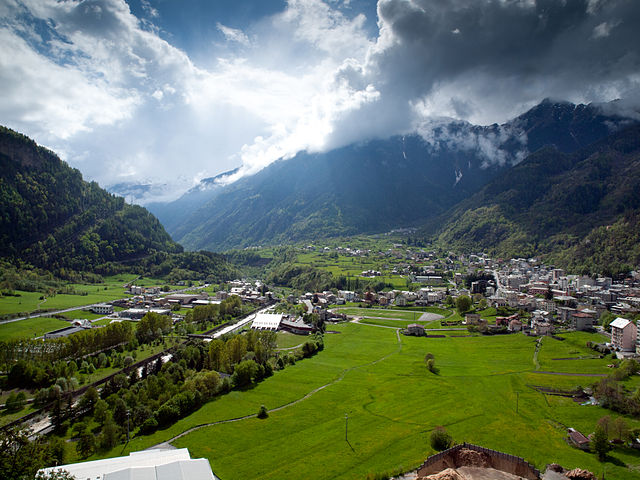
Понте-ди-Леньо
- коммуна Италии
Hiking in Понте-ди-Леньо
Ponte di Legno is a beautiful alpine resort located in the Lombardy region of northern Italy, nestled within the stunning landscape of the Adamello-Presanella Natural Park. This area is renowned for its breathtaking mountain scenery, diverse flora and fauna, and a variety of hiking trails suitable for all levels of hikers....
- Страна:
- Почтовый код: 25056
- Телефонный код: 0364
- Код автомобильного номера: BS
- Координаты: 46° 15' 34" N, 10° 30' 34" E
- GPS треки (wikiloc): [Ссылка]
- Высота над уровнем моря: 1258 м m
- Площадь: 100.43 кв.км
- Население: 1730
- Веб сайт: [Ссылка]


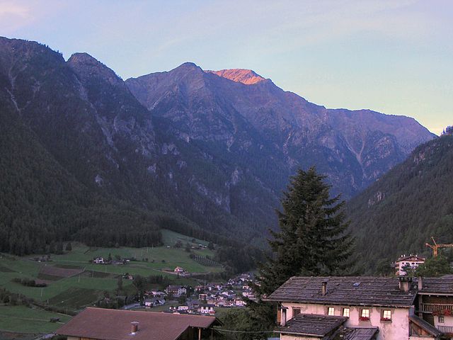
Пейо
- коммуна Италии
Hiking in Пейо
Peio, located in the beautiful Val di Peio in the Trentino region of northern Italy, is a fantastic hiking destination that offers a mix of stunning alpine scenery, diverse trails, and rich natural and cultural heritage. Here’s what you need to know about hiking in Peio:...
- Страна:
- Почтовый код: 38024
- Телефонный код: 0463
- Код автомобильного номера: TN
- Координаты: 46° 22' 0" N, 10° 40' 0" E
- GPS треки (wikiloc): [Ссылка]
- Высота над уровнем моря: 1173 м m
- Площадь: 160.50 кв.км
- Население: 1842
- Веб сайт: [Ссылка]

Сондало
- коммуна Италии
Hiking in Сондало
Sondalo is a charming town located in the Valtellina Valley in northern Italy, surrounded by stunning natural landscapes that make it an excellent destination for hiking enthusiasts. The area is characterized by its dramatic mountains, lush forests, and rich biodiversity....
- Страна:
- Почтовый код: 23035
- Телефонный код: 0342
- Код автомобильного номера: SO
- Координаты: 46° 20' 0" N, 10° 20' 0" E
- GPS треки (wikiloc): [Ссылка]
- Высота над уровнем моря: 900 м m
- Площадь: 95.45 кв.км
- Население: 4114
- Веб сайт: [Ссылка]
Вальдизотто
- коммуна Италии
Hiking in Вальдизотто
Valdisotto is a beautiful destination located in the Valtellina region of Lombardy, Italy, known for its stunning landscapes, rich natural heritage, and excellent hiking opportunities. Nestled in the Alps, Valdisotto offers a range of trails that cater to hikers of all skill levels, from easy walks to challenging alpine routes....
- Страна:
- Почтовый код: 23030
- Телефонный код: 0342
- Код автомобильного номера: SO
- Координаты: 46° 25' 0" N, 10° 21' 0" E
- GPS треки (wikiloc): [Ссылка]
- Высота над уровнем моря: 1141 м m
- Площадь: 89.57 кв.км
- Население: 3601
- Веб сайт: [Ссылка]


Бормио
- коммуна Италии
Hiking in Бормио
Bormio is a beautiful town located in the Italian Alps, specifically within the Lombardy region. It's well known for its stunning landscapes, rich history, and access to a variety of outdoor activities, including hiking. Here’s an overview of what to expect when hiking in Bormio:...
- Страна:
- Почтовый код: 23032
- Телефонный код: 0342
- Код автомобильного номера: SO
- Координаты: 46° 28' 0" N, 10° 22' 0" E
- GPS треки (wikiloc): [Ссылка]
- Высота над уровнем моря: 1225 м m
- Площадь: 41.44 кв.км
- Население: 4194
- Веб сайт: [Ссылка]

Мартелло
- коммуна Италии
Hiking in Мартелло
Martell is a picturesque valley located in South Tyrol, Italy, known for its breathtaking landscapes, diverse flora and fauna, and excellent hiking trails. Here are some key points to consider if you're planning a hiking trip to Martell:...
- Страна:
- Почтовый код: 39020
- Телефонный код: 0473
- Код автомобильного номера: BZ
- Координаты: 46° 33' 17" N, 10° 46' 50" E
- GPS треки (wikiloc): [Ссылка]
- Высота над уровнем моря: 1312 м m
- Площадь: 142.8 кв.км
- Население: 853
- Веб сайт: [Ссылка]

Стельвио
- коммуна в Италии
Hiking in Стельвио
Stilfs, also known as Stilfs or Stelvio, is a charming village located in the South Tyrol region of northern Italy. It serves as a fantastic gateway for hiking enthusiasts looking to explore the beautiful and diverse landscapes of the nearby Stelvio National Park. Here are some highlights of hiking in and around Stilfs:...
- Страна:
- Почтовый код: 39020
- Телефонный код: 0473
- Код автомобильного номера: BZ
- Координаты: 46° 35' 52" N, 10° 32' 45" E
- GPS треки (wikiloc): [Ссылка]
- Высота над уровнем моря: 1311 м m
- Площадь: 141.63 кв.км
- Население: 1150
- Веб сайт: [Ссылка]