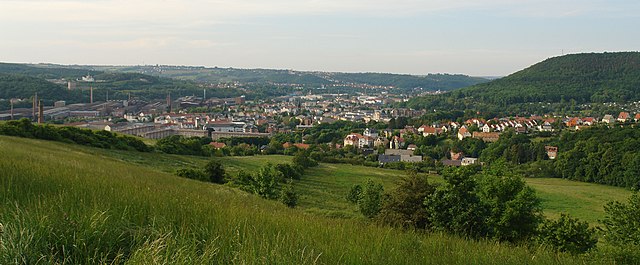
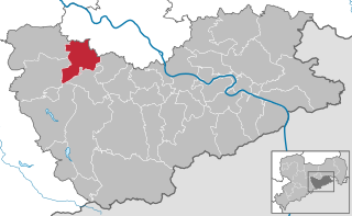
Тарандт (Tharandt, Tharandt)

 Hiking in Тарандт
Tharandt, located in Saxony, Germany, is known for its beautiful natural landscapes and excellent hiking opportunities. The region is characterized by its dense forests, rolling hills, and stunning vistas. Here are some highlights and tips for hiking in Tharandt:
Hiking Trails
-
Tharandter Wald: This is a large forest area that offers numerous trails ranging from easy walks to more challenging hikes. The forest is home to a diverse range of flora and fauna, making it perfect for nature lovers.
-
Schwedenlöcher: This is a picturesque area known for its unique rock formations and scenic views. The trails here can be rugged, so it's advisable to wear suitable hiking boots.
-
Langebrücker Tal: This valley features several well-marked trails that lead through picturesque landscapes, including streams and meadows.
-
Saxon Switzerland National Park: While not directly in Tharandt, it's relatively close and offers some of the most stunning hiking in the region, with dramatic sandstone cliffs and breathtaking views.
Preparing for Your Hike
- Map & Trail Information: Download maps or get local hiking guides to help navigate the trails. Many paths are well-marked, but having a map is always a good idea.
- Weather Conditions: Check the weather forecast before heading out, as conditions can change rapidly, especially in forested areas.
- Equipment: Wear appropriate clothing and sturdy footwear. A backpack with water, snacks, a first aid kit, and a flashlight is also recommended.
- Wildlife Awareness: Be aware of local wildlife and practice Leave No Trace principles to keep the area pristine.
Accessibility
Tharandt is accessible by public transportation, with train services connecting it to larger cities like Dresden. There are also parking facilities if you decide to drive.
Local Amenities
After a day of hiking, you can enjoy the local hospitality in Tharandt, which includes quaint cafes and restaurants serving traditional German cuisine.
Overall, hiking in Tharandt offers a wonderful experience for both novice and experienced hikers, with a chance to enjoy the tranquility of nature and the beauty of the Saxon landscape. Always remember to respect the environment and have fun exploring!
- Страна:

- Почтовый код: 01737
- Телефонный код: 035203
- Координаты: 50° 59' 0" N, 13° 34' 51" E


- GPS треки (wikiloc): [Ссылка]
- Высота над уровнем моря: 214 м m
- Площадь: 71.22 кв.км
- Население: 5380
- Веб сайт: https://www.tharandt.de/
- Википедия русская: wiki(ru)
- Википедия английская: wiki(en)
- Википедия национальная: wiki(de)
- Хранилище Wikidata: Wikidata: Q8245
- Галерея изображений в википедии: [Ссылка]
- Катеория в википедии: [Ссылка]
- код Freebase: [/m/08g7gf]
- код Freebase: [/m/08g7gf]
- код GeoNames: Альт: [6550831]
- код GeoNames: Альт: [6550831]
- код VIAF: Альт: [312810779]
- код VIAF: Альт: [312810779]
- ID отношения в OpenStreetMap: [455470]
- ID отношения в OpenStreetMap: [455470]
- код GND: Альт: [4106217-6]
- код GND: Альт: [4106217-6]
- код LCNAF: Альт: [n83136819]
- код LCNAF: Альт: [n83136819]
- место в MusicBrainz: [749a4149-46f0-45a3-be2f-bacc7ad8f8ea]
- место в MusicBrainz: [749a4149-46f0-45a3-be2f-bacc7ad8f8ea]
- WOEID: [699150]
- WOEID: [699150]
- код Historical Gazetteer: [THANDTJO60TX]
- код Historical Gazetteer: [THANDTJO60TX]
- код NKC: [ge892704]
- код NKC: [ge892704]
- идентификатор муниципалитетов в Германии: 14628400
- идентификатор муниципалитетов в Германии: 14628400
Включает регионы:
Spechtshausen
Hiking in Spechtshausen
Spechtshausen is a quaint village located in the scenic region of Lower Saxony, Germany. While it's not as widely recognized for hiking as other areas, the surrounding landscapes offer beautiful paths and trails that cater to both casual walkers and experienced hikers....
- Страна:
- Почтовый код: 01737
- Телефонный код: 035203
- Координаты: 50° 59' 21" N, 13° 31' 29" E
- GPS треки (wikiloc): [Ссылка]
- Высота над уровнем моря: 386 м m
Fördergersdorf
Hiking in Fördergersdorf
Fördergersdorf is a small village located in Germany, specifically in the state of Saxony. While it may not be a widely-known hiking destination, the surrounding region offers opportunities for outdoor activities, particularly in the context of exploring the beautiful landscapes of Saxony....
- Страна:
- Почтовый код: 01737
- Телефонный код: 035203
- Координаты: 50° 59' 46" N, 13° 32' 23" E
- GPS треки (wikiloc): [Ссылка]
- Высота над уровнем моря: 326 м m
- Площадь: 3.21 кв.км
Grillenburg
Hiking in Grillenburg
Grillenburg, located in the Tharandt region of Saxony, Germany, is a lovely area for hiking enthusiasts. The region is characterized by its beautiful forests, hills, and diverse ecosystems, making it a great destination for outdoor activities....
- Страна:
- Почтовый код: 01737
- Телефонный код: 035202
- Координаты: 50° 57' 10" N, 13° 30' 26" E
- GPS треки (wikiloc): [Ссылка]
- Высота над уровнем моря: 375 м m
- Площадь: 43.12 кв.км


Großopitz
Hiking in Großopitz
Großopitz, a picturesque village in Saxony, Germany, offers various hiking opportunities for outdoor enthusiasts. While not as well-known as some larger hiking destinations, its scenic landscapes and tranquil countryside can be very rewarding....
- Страна:
- Почтовый код: 01737
- Телефонный код: 035203
- Координаты: 50° 59' 55" N, 13° 35' 32" E
- GPS треки (wikiloc): [Ссылка]
- Высота над уровнем моря: 322 м m
Kurort Hartha
Hiking in Kurort Hartha
Kurort Hartha is a charming spa town located in Saxony, Germany, and it offers beautiful hiking opportunities surrounded by nature. The region is characterized by its picturesque landscapes, including forests, hills, and rivers. Here are some highlights and tips for hiking in and around Kurort Hartha:...
- Страна:
- Почтовый код: 01737
- Телефонный код: 035203
- Координаты: 50° 58' 49" N, 13° 32' 40" E
- GPS треки (wikiloc): [Ссылка]
- Высота над уровнем моря: 349 м m
- Площадь: 4.26 кв.км
Pohrsdorf
Hiking in Pohrsdorf
Pohrsdorf is a charming village in Saxony, Germany, situated close to the Dresden area. The region is known for its picturesque landscapes, lush forests, and varied terrain, making it a great spot for hiking enthusiasts....
- Страна:
- Почтовый код: 01737
- Телефонный код: 035203
- Координаты: 50° 59' 48" N, 13° 31' 41" E
- GPS треки (wikiloc): [Ссылка]
- Высота над уровнем моря: 340 м m
Граничит с регионами:


Клингенберг
- населённый пункт в Саксонии
Hiking in Клингенберг
Klingenberg, located in Saxony, Germany, is an excellent destination for hiking enthusiasts. Nestled among picturesque landscapes that include rolling hills, forests, and vineyards, Klingenberg offers a variety of trails suited for different skill levels....
- Страна:
- Почтовый код: 01774
- Телефонный код: 037326; 035202; 035058; 035055
- Координаты: 50° 54' 7" N, 13° 32' 39" E
- GPS треки (wikiloc): [Ссылка]
- Высота над уровнем моря: 410 м m
- Площадь: 86.56 кв.км
- Население: 6817
- Веб сайт: [Ссылка]
Фрайталь
- город в Саксонии
Hiking in Фрайталь
Freital, located in Saxony, Germany, is surrounded by beautiful landscapes and offers various hiking opportunities for both novice and experienced hikers. Here are some highlights about hiking in the Freital area:...
- Страна:
- Почтовый код: 01705; 8225; 8212; 8211; 8210
- Телефонный код: 0351
- Координаты: 51° 1' 0" N, 13° 39' 0" E
- GPS треки (wikiloc): [Ссылка]
- Высота над уровнем моря: 171 м m
- Площадь: 40.45 кв.км
- Население: 39300
- Веб сайт: [Ссылка]


Дорфхайн
Hiking in Дорфхайн
Dorfhain, a small village in Germany, is known for its picturesque landscapes and natural surroundings, making it a great spot for hiking enthusiasts. Here are some aspects to consider if you're planning a hiking trip there:...
- Страна:
- Почтовый код: 01738
- Телефонный код: 035055
- Код автомобильного номера: PIR
- Координаты: 50° 56' 0" N, 13° 34' 0" E
- GPS треки (wikiloc): [Ссылка]
- Высота над уровнем моря: 341 м m
- Площадь: 6.25 кв.км
- Население: 1073
- Веб сайт: [Ссылка]


Вильсдруф
Hiking in Вильсдруф
Wilsdruff, located in Saxony, Germany, is a charming town that offers access to various hiking opportunities in the surrounding area. The region is characterized by scenic landscapes, forests, and hills, making it suitable for both novice and experienced hikers. Here are some highlights and tips for hiking in and around Wilsdruff:...
- Страна:
- Почтовый код: 01723; 8224
- Телефонный код: 0351; 035203; 035209; 035204
- Код автомобильного номера: PIR
- Координаты: 51° 3' 8" N, 13° 32' 18" E
- GPS треки (wikiloc): [Ссылка]
- Высота над уровнем моря: 273 м m
- Площадь: 81.6 кв.км
- Население: 14163
- Веб сайт: [Ссылка]