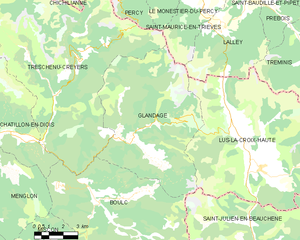
Treschenu-Creyers (Treschenu-Creyers)

- коммуна во Франции
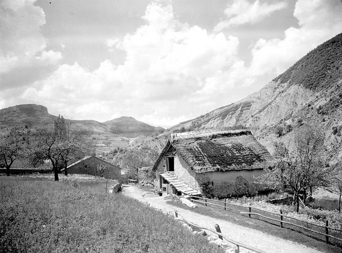
 Hiking in Treschenu-Creyers
Treschenu-Creyers is a picturesque village located in the heart of the French Alps, near the beautiful Vercors National Park. The stunning natural landscape surrounding the village offers many opportunities for hiking enthusiasts of all skill levels. Here’s a brief overview of what you can expect when hiking in the area:
Trails and Hikes
-
Variety of Trails: The region boasts a network of well-marked trails that cater to diverse interests—ranging from leisurely walks suitable for families to challenging mountain hikes for experienced trekkers.
-
Scenic Routes: Hiking trails around Treschenu-Creyers often feature breathtaking views of the surrounding mountains, rolling hills, and valleys. Look out for the stunning cliffs and rock formations distinctive to the Vercors region.
-
Flora and Fauna: The area's rich biodiversity offers hikers a great opportunity to observe various plant species and wildlife. Keep an eye out for rare flowers and the unique fauna that populate the region.
-
Seasonal Hiking: Late spring through early autumn is the best time for hiking, as trails are clear of snow, and the weather is generally mild. Winter hiking and snowshoeing are also popular in the area, offering a different but equally enchanting experience.
Hiking Tips
- Preparation: Before embarking on a hike, ensure you have the appropriate gear, including sturdy hiking boots, weather-appropriate clothing, and sufficient food and water.
- Map and Compass: While many trails are well-marked, carrying a map or GPS device is always a good idea, especially for longer hikes.
- Respect Nature: Follow Leave No Trace principles to minimize your impact on the environment, and remember to stick to designated paths to preserve local wildlife and plant habitats.
- Local Information: Check in with local guides or visitor centers for trail conditions, recommendations, and any safety advisories.
Conclusion
Treschenu-Creyers is a wonderful destination for hiking, with its stunning landscapes and well-maintained trails. Whether you are a novice or an experienced hiker, you'll find plenty to explore and enjoy in this beautiful alpine setting. Make sure to take time to appreciate the views and the tranquility of nature!
- Страна:

- Почтовый код: 26410
- Координаты: 44° 44' 15" N, 5° 33' 14" E


- GPS треки (wikiloc): [Ссылка]
- Площадь: 82.04 кв.км
- Население: 112
- Википедия английская: wiki(en)
- Википедия национальная: wiki(fr)
- Хранилище Wikidata: Wikidata: Q266133
- Катеория в википедии: [Ссылка]
- код Freebase: [/m/03mhll8]
- код GeoNames: Альт: [6616267]
- номер SIREN: [212603542]
- код BNF: [152532146]
- код тезауруса PACTOLS: [pcrtMQh5VlO7Nu]
- код муниципалитета INSEE: 26354
Граничит с регионами:

Glandage
- коммуна во Франции
Hiking in Glandage
It seems like there might be a typo in your request, as "Glandage" does not correspond to a well-known hiking location. If you meant "Glandage" in France, located in the Drôme department, I'd be happy to provide information about hiking in that area....
- Страна:
- Почтовый код: 26410
- Координаты: 44° 41' 17" N, 5° 35' 54" E
- GPS треки (wikiloc): [Ссылка]
- Площадь: 52.11 кв.км
- Население: 115


Laval-d'Aix
- коммуна во Франции
Hiking in Laval-d'Aix
Laval-d'Aix, located in the Auvergne-Rhône-Alpes region of France, offers stunning scenic beauty and a variety of hiking opportunities. Here are some key points to consider:...
- Страна:
- Почтовый код: 26150
- Координаты: 44° 42' 48" N, 5° 25' 53" E
- GPS треки (wikiloc): [Ссылка]
- Площадь: 20.05 кв.км
- Население: 124

Boulc
- коммуна во Франции
Hiking in Boulc
Boulc is a charming village located in the Drôme department of the Auvergne-Rhône-Alpes region in southeastern France. It is surrounded by beautiful natural landscapes, making it a great destination for hiking enthusiasts....
- Страна:
- Почтовый код: 26410
- Координаты: 44° 38' 52" N, 5° 34' 1" E
- GPS треки (wikiloc): [Ссылка]
- Площадь: 57.35 кв.км
- Население: 124


Ле-Монестье-дю-Перси
- коммуна во Франции
Hiking in Ле-Монестье-дю-Перси
Le Monestier-du-Percy is a picturesque commune located in the Isère department of the Auvergne-Rhône-Alpes region in southeastern France. It's a fantastic destination for hiking enthusiasts, offering a mix of serene landscapes, lush forests, and stunning mountain vistas....
- Страна:
- Почтовый код: 38930
- Координаты: 44° 47' 39" N, 5° 39' 32" E
- GPS треки (wikiloc): [Ссылка]
- Площадь: 14.99 кв.км
- Население: 249
- Веб сайт: [Ссылка]


Перси
Hiking in Перси
Hiking in Percy, Isère, is a wonderful experience for outdoor enthusiasts, as it offers access to breathtaking landscapes and a variety of trails suitable for different skill levels. Located in the Auvergne-Rhône-Alpes region of France, Percy is surrounded by the stunning natural beauty of the Vercors massif and the Chartreuse mountains....
- Страна:
- Почтовый код: 38930
- Координаты: 44° 48' 5" N, 5° 38' 59" E
- GPS треки (wikiloc): [Ссылка]
- Площадь: 15.93 кв.км
- Население: 165
- Веб сайт: [Ссылка]


Сен-Морис-ан-Триев
- коммуна во Франции
Hiking in Сен-Морис-ан-Триев
Saint-Maurice-en-Trièves is a charming village nestled in the Trièves region of the French Alps, known for its stunning natural landscapes, diverse wildlife, and a variety of hiking opportunities. Here are some key points to consider if you're planning a hiking trip in this area:...
- Страна:
- Почтовый код: 38930
- Координаты: 44° 45' 52" N, 5° 39' 50" E
- GPS треки (wikiloc): [Ссылка]
- Площадь: 12.94 кв.км
- Население: 156

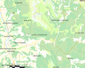
Châtillon-en-Diois
- коммуна во Франции
Hiking in Châtillon-en-Diois
Châtillon-en-Diois is a picturesque commune located in the Drôme department of France, nestled in the foothills of the Vercors Mountains. It is a great destination for hiking, offering a variety of trails that cater to different skill levels and preferences. Here are some highlights about hiking in and around this beautiful area:...
- Страна:
- Почтовый код: 26410
- Координаты: 44° 41' 41" N, 5° 29' 3" E
- GPS треки (wikiloc): [Ссылка]
- Площадь: 28.02 кв.км
- Население: 555
- Веб сайт: [Ссылка]


Шишильянк
- коммуна во Франции
Hiking in Шишильянк
Chichilianne is a charming village located in the Vercors Regional Natural Park in southeastern France, often referred to as the "Gateway to the Vercors." The area is known for its stunning natural landscapes, including rugged mountains, deep valleys, and diverse flora and fauna, making it an excellent destination for hiking enthusiasts....
- Страна:
- Почтовый код: 38930
- Координаты: 44° 48' 42" N, 5° 34' 20" E
- GPS треки (wikiloc): [Ссылка]
- Площадь: 62.48 кв.км
- Население: 284
- Веб сайт: [Ссылка]