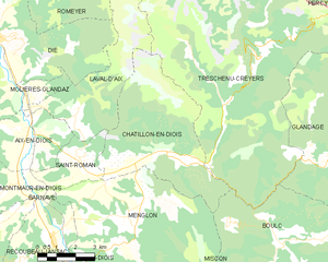
canton of Châtillon-en-Diois (canton de Châtillon-en-Diois)
 Hiking in canton of Châtillon-en-Diois
Canton de Châtillon-en-Diois, located in the Drôme department of France, is a picturesque area that offers a variety of hiking opportunities. It is known for its stunning landscapes, including the dramatic cliffs of the Vercors mountains, lush valleys, and charming villages. Here are some highlights for hiking in this region:
Trails and Routes:
-
GR91 Trail: This long-distance trail is part of the Grande Randonnée network and runs through the Vercors Regional Natural Park. It offers beautiful views, diverse terrain, and a chance to experience the local flora and fauna.
-
Local Loop Trails: There are several loop trails around Châtillon-en-Diois that cater to different skill levels. These trails often take you through vineyards, forests, and past historical sites, such as old stone houses and ruins.
-
Col de Rousset: This area offers trails that can be explored year-round, with snowshoeing routes in winter and great views of the surrounding peaks every season.
Scenery and Wildlife:
- Expect breathtaking views of the Vercors mountain range, deep gorges, and the tranquil landscape of the Diois region. The biodiversity is remarkable, and you may encounter various wildlife including deer, foxes, and numerous bird species.
Practical Tips:
- Best Time to Visit: Spring (April to June) and autumn (September to October) are ideal for hiking, offering moderate temperatures and beautiful natural scenery.
- Equipment: Wear sturdy hiking boots and bring a good backpack with essentials like water, snacks, a map, and a first aid kit. If you're hiking in winter, snowshoes or crampons may be necessary.
- Navigation: While many trails are well-marked, having a map or GPS device is advisable, especially for less-traveled routes.
- Safety: Check the weather forecast before you head out, and always inform someone about your hiking plan.
Cultural Experiences:
Hiking in the Canton de Châtillon-en-Diois is not just about nature but also experiencing the local culture. You may come across quaint villages with traditional architecture, markets, and artisanal crafts. Take time to sample local cuisine in the area’s small restaurants or cafés.
Overall, the Canton de Châtillon-en-Diois offers a diverse and enjoyable hiking experience that can cater to all skill levels while providing an authentic glimpse into the natural beauty and cultural richness of southeastern France.
- Страна:

- Столица: Châtillon-en-Diois
- Координаты: 44° 41' 19" N, 5° 32' 16" E


- GPS треки (wikiloc): [Ссылка]
- Хранилище Wikidata: Wikidata: Q369046
- код кантона INSEE: [2606]
Включает регионы:

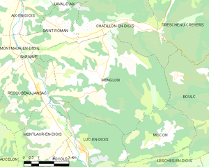
Menglon
- коммуна во Франции
Hiking in Menglon
Menglon is a picturesque village located in the Drôme department of southeastern France, known for its proximity to the stunning Vercors Regional Natural Park. This area offers a variety of hiking opportunities suitable for different skill levels, making it a great destination for outdoor enthusiasts....
- Страна:
- Почтовый код: 26410
- Координаты: 44° 39' 51" N, 5° 27' 44" E
- GPS треки (wikiloc): [Ссылка]
- Площадь: 36.47 кв.км
- Население: 485

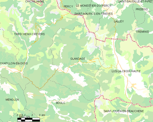
Glandage
- коммуна во Франции
Hiking in Glandage
It seems like there might be a typo in your request, as "Glandage" does not correspond to a well-known hiking location. If you meant "Glandage" in France, located in the Drôme department, I'd be happy to provide information about hiking in that area....
- Страна:
- Почтовый код: 26410
- Координаты: 44° 41' 17" N, 5° 35' 54" E
- GPS треки (wikiloc): [Ссылка]
- Площадь: 52.11 кв.км
- Население: 115

Boulc
- коммуна во Франции
Hiking in Boulc
Boulc is a charming village located in the Drôme department of the Auvergne-Rhône-Alpes region in southeastern France. It is surrounded by beautiful natural landscapes, making it a great destination for hiking enthusiasts....
- Страна:
- Почтовый код: 26410
- Координаты: 44° 38' 52" N, 5° 34' 1" E
- GPS треки (wikiloc): [Ссылка]
- Площадь: 57.35 кв.км
- Население: 124

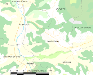
Saint-Roman
- коммуна во Франции
Hiking in Saint-Roman
Saint-Roman is a charming commune located in the Drôme department of southeastern France, known for its beautiful natural landscapes and outdoor activities. Hiking in this region offers a unique experience, with varying terrains and stunning views of the surrounding mountains and valleys....
- Страна:
- Почтовый код: 26410
- Координаты: 44° 41' 29" N, 5° 25' 58" E
- GPS треки (wikiloc): [Ссылка]
- Площадь: 7.1 кв.км
- Население: 178
- Веб сайт: [Ссылка]


Treschenu-Creyers
- коммуна во Франции
Hiking in Treschenu-Creyers
Treschenu-Creyers is a picturesque village located in the heart of the French Alps, near the beautiful Vercors National Park. The stunning natural landscape surrounding the village offers many opportunities for hiking enthusiasts of all skill levels. Here’s a brief overview of what you can expect when hiking in the area:...
- Страна:
- Почтовый код: 26410
- Координаты: 44° 44' 15" N, 5° 33' 14" E
- GPS треки (wikiloc): [Ссылка]
- Площадь: 82.04 кв.км
- Население: 112

Châtillon-en-Diois
- коммуна во Франции
Hiking in Châtillon-en-Diois
Châtillon-en-Diois is a picturesque commune located in the Drôme department of France, nestled in the foothills of the Vercors Mountains. It is a great destination for hiking, offering a variety of trails that cater to different skill levels and preferences. Here are some highlights about hiking in and around this beautiful area:...
- Страна:
- Почтовый код: 26410
- Координаты: 44° 41' 41" N, 5° 29' 3" E
- GPS треки (wikiloc): [Ссылка]
- Площадь: 28.02 кв.км
- Население: 555
- Веб сайт: [Ссылка]


Lus-la-Croix-Haute
- коммуна во Франции
Hiking in Lus-la-Croix-Haute
Lus-la-Croix-Haute is a beautiful destination for hiking enthusiasts, located in the picturesque Alps of France. This charming village offers a variety of trails that cater to different levels of hikers, from beginners to experienced adventurers....
- Страна:
- Почтовый код: 26620
- Координаты: 44° 39' 55" N, 5° 42' 20" E
- GPS треки (wikiloc): [Ссылка]
- Площадь: 87.2 кв.км
- Население: 549