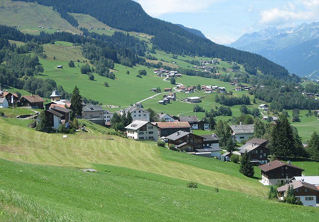
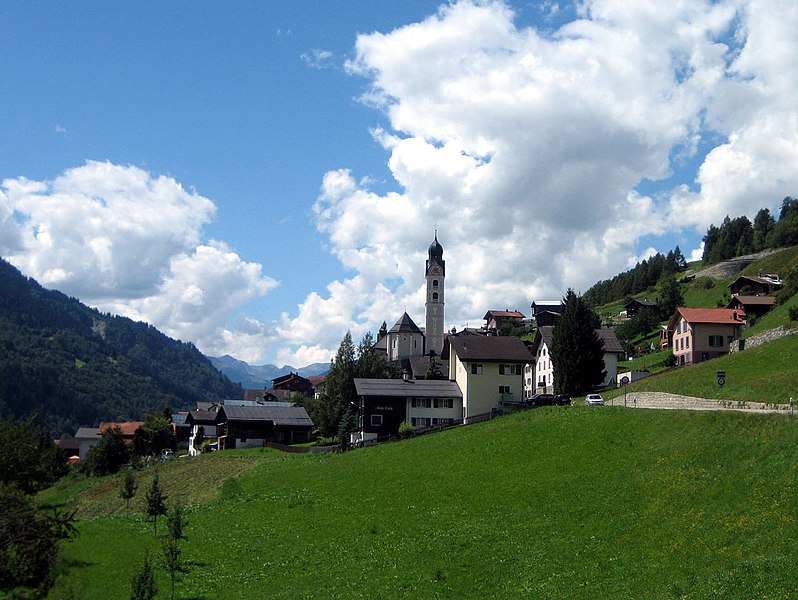
Трун (Trun, Trun)

 Hiking in Трун
Trun, a picturesque village located in the Surselva region of Graubünden, Switzerland, offers a range of hiking opportunities that showcase the stunning natural beauty of the Swiss Alps. Here are some key points to consider for hiking in and around Trun:
Hiking Trails
-
Varied Terrain: The area around Trun features a mix of forested pathways, alpine meadows, and panoramic mountain views. Trails cater to different skill levels, from easy walks suitable for families to challenging hikes for more experienced trekkers.
-
Local Highlights: Specific trails may lead you to notable sights such as:
- Piz Mundaun: A hike towards the peak provides stunning views of the surrounding valleys.
- Lake Mitgel: A serene spot for a break, perfect for picnics or photography.
- The Rhine Gorge (Grand Canyon of Switzerland): A popular destination nearby that offers spectacular views and diverse hiking options.
-
Marked Trails: The Swiss hiking network is well-marked, with many trails signposted with distances and estimated hiking times. Make sure to carry a detailed map or use a navigation app for extra help.
Seasonal Considerations
- Spring and Summer: Ideal for wildflower viewing, the trails are generally clear of snow, making them accessible.
- Autumn: The fall colors turn the landscape into a vibrant palette, providing a beautiful backdrop for hiking.
- Winter: Snowshoeing and winter hiking can be enjoyed, but it’s essential to check trail conditions and safety.
Preparation and Safety
- Gear: Always wear sturdy hiking boots and carry necessary equipment such as a map, compass, sufficient water, snacks, and weather-appropriate clothing.
- Check Weather Conditions: The weather can change rapidly in the mountains, so always check the forecast before heading out.
Local Tips
- Guided Tours: If you're new to the area or prefer a guided experience, consider joining a local hiking group or hiring a guide who can share insights about the region’s flora, fauna, and cultural history.
- Accommodation: Trun has a selection of accommodations, from cozy guesthouses to hotels, making it convenient for hikers to stay overnight.
Accessibility
- Trun is accessible by public transport and is well-connected by train to larger cities in Switzerland. This makes it a great destination for both day trips and extended stays.
By exploring the trails around Trun, you can enjoy the serene beauty of the Swiss Alps while experiencing the tranquility of local life. Always respect the natural environment, follow local guidelines, and enjoy your hiking adventures!
- Страна:

- Почтовый код: 7166
- Телефонный код: 081
- Код автомобильного номера: GR
- Координаты: 46° 44' 36" N, 8° 58' 59" E


- GPS треки (wikiloc): [Ссылка]
- Высота над уровнем моря: 904 м m
- Площадь: 43.07 кв.км
- Население: 1172
- Веб сайт: http://www.trun.ch
- Википедия русская: wiki(ru)
- Википедия английская: wiki(en)
- Википедия национальная: wiki(de)
- Хранилище Wikidata: Wikidata: Q64951
- Катеория в википедии: [Ссылка]
- код Freebase: [/m/0g7q1l]
- код GeoNames: Альт: [2658300]
- код VIAF: Альт: [312660415]
- ID отношения в OpenStreetMap: [1684193]
- идентификатор местоположения ArchINFORM: [12748]
- место в MusicBrainz: [5daae48f-5df4-47fa-a330-d76daca356fb]
- идентификатор HDS: [1619]
- код швейцарского муниципалитета: [3987]
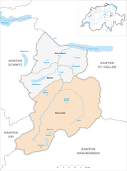
Граничит с регионами:

Оберзаксен
Hiking in Оберзаксен
Obersaxen is a beautiful region located in the scenic Swiss Alps, specifically in the canton of Graubünden. It is known for its stunning landscapes, diverse trails, and outdoor activities, making it an excellent destination for hiking enthusiasts. Here are some highlights and tips for hiking in Obersaxen:...
- Страна:
- Почтовый код: 7134
- Телефонный код: 081
- Координаты: 46° 44' 0" N, 9° 6' 0" E
- GPS треки (wikiloc): [Ссылка]
- Высота над уровнем моря: 1281 м m
- Площадь: 61.77 кв.км
- Веб сайт: [Ссылка]


Брайль-Бригельс
Hiking in Брайль-Бригельс
Breil/Brigels is a picturesque village located in the Grisons region of Switzerland, known for its stunning landscapes and a variety of outdoor activities, including hiking. The region offers a range of hiking trails suitable for different skill levels, making it an excellent destination for both novice and experienced hikers....
- Страна:
- Почтовый код: 7165
- Телефонный код: 081
- Код автомобильного номера: GR
- Координаты: 46° 47' 7" N, 9° 2' 0" E
- GPS треки (wikiloc): [Ссылка]
- Высота над уровнем моря: 2189 м m
- Площадь: 50.64 кв.км
- Население: 1248
- Веб сайт: [Ссылка]

Сумвич
Hiking in Сумвич
Sumvitg, located in the Canton of Graubünden in Switzerland, is a charming village that offers stunning landscapes and a variety of hiking opportunities. The region is characterized by its beautiful valleys, alpine meadows, and stunning mountain vistas....
- Страна:
- Почтовый код: 7175
- Телефонный код: 081
- Код автомобильного номера: GR
- Координаты: 46° 42' 59" N, 8° 55' 59" E
- GPS треки (wikiloc): [Ссылка]
- Высота над уровнем моря: 1056 м m
- Площадь: 101.88 кв.км
- Население: 1179
- Веб сайт: [Ссылка]

Glarus Süd
Hiking in Glarus Süd
Glarus Süd, located in the canton of Glarus in Switzerland, is a fantastic destination for hiking enthusiasts. This region boasts stunning landscapes, ranging from lush valleys to rugged mountain terrains. Here are some key points about hiking in Glarus Süd:...
- Страна:
- Почтовый код: 8756, 8762, 8765, 8766, 8767, 8772, 8773, 8774, 8775, 8777, 8782, 8783, 8784
- Телефонный код: 055
- Код автомобильного номера: GL
- Координаты: 46° 59' 40" N, 9° 4' 27" E
- GPS треки (wikiloc): [Ссылка]
- Высота над уровнем моря: 521 м m
- Площадь: 430.2 кв.км
- Население: 9581
- Веб сайт: [Ссылка]