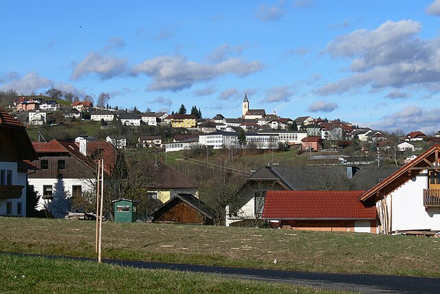
Ульриксберг (Ulrichsberg, Ulrichsberg)
 Hiking in Ульриксберг
Ulrichsberg is a beautiful location for hiking, situated in the Upper Austria region near the border with the Czech Republic. This area is known for its stunning natural landscapes, including rolling hills, lush forests, and scenic views.
Key Hiking Information:
-
Trails:
- There are numerous hiking trails suitable for various skill levels. Whether you are a beginner or an experienced hiker, you can find routes that cater to your preferences.
- Popular trails often include well-marked paths through the surrounding nature parks, such as the Böhmerwald (Bohemian Forest).
-
Scenic Spots:
- Many trails offer viewpoints that overlook the surrounding valleys and forests. Make sure to take breaks to enjoy the scenery and take photos.
-
Wildlife and Flora:
- The region is rich in biodiversity. Keep an eye out for local wildlife, such as deer and a variety of bird species. The flora changes with the seasons, providing beautiful displays of wildflowers in spring and summer.
-
Best Time to Hike:
- The best times for hiking in Ulrichsberg are typically late spring through early autumn (May to October), when the weather is mild and the trails are accessible.
- Summer can be warmer, so start early to avoid heat during the day.
-
Preparation and Safety:
- Always check the weather conditions and prepare accordingly. Bring plenty of water, snacks, and appropriate clothing and footwear.
- It’s also good practice to inform someone of your hiking plans and expected return time.
-
Local Attractions:
- Besides hiking, consider visiting local cultural sites or participating in regional activities. Ulrichsberg has a rich local culture, and exploring it can enhance your hiking experience.
-
Guided Tours:
- If you're unfamiliar with the area or prefer company, consider joining a guided hiking tour. Local guides can provide insights into the natural environment and cultural history of the area.
Always remember to follow Leave No Trace principles to help preserve the natural beauty of Ulrichsberg for future hikers. Happy hiking!
- Страна:

- Почтовый код: 4161
- Телефонный код: 07288
- Код автомобильного номера: RO
- Координаты: 48° 40' 32" N, 13° 54' 44" E


- GPS треки (wikiloc): [Ссылка]
- Высота над уровнем моря: 626 м m
- Площадь: 57 кв.км
- Население: 2843
- Веб сайт: http://www.ulrichsberg.at/
- Википедия русская: wiki(ru)
- Википедия английская: wiki(en)
- Википедия национальная: wiki(de)
- Хранилище Wikidata: Wikidata: Q693796
- Катеория в википедии: [Ссылка]
- код Freebase: [/m/03gv9nl]
- код VIAF: Альт: [247381764]
- код GND: Альт: [4124344-4]
- место в MusicBrainz: [4dd68811-b0ba-4128-8f45-2e6bab3d429d]
- код австрийского муниципалитета: [41342]
Граничит с регионами:

Aigen-Schlägl
Hiking in Aigen-Schlägl
Aigen-Schlägl, located in the scenic region of Austria, offers some beautiful hiking opportunities, especially for those looking to explore the lush landscapes and picturesque nature typical of the area. Here are some key points about hiking in Aigen-Schlägl:...
- Страна:
- Почтовый код: 4160
- Телефонный код: 07281
- Код автомобильного номера: RO
- Координаты: 48° 38' 48" N, 13° 58' 21" E
- GPS треки (wikiloc): [Ссылка]
- Высота над уровнем моря: 596 м m
- Площадь: 45.99 кв.км
- Население: 3212
- Веб сайт: [Ссылка]


Брайтенберг
Hiking in Брайтенберг
Breitenberg, located in Lower Bavaria, is a fantastic destination for hiking enthusiasts. The region features a mix of scenic landscapes, charming villages, and diverse flora and fauna, making it ideal for both casual hikers and experienced trekkers....
- Страна:

- Почтовый код: 94139
- Телефонный код: 08584
- Код автомобильного номера: PA
- Координаты: 48° 42' 14" N, 13° 47' 39" E
- GPS треки (wikiloc): [Ссылка]
- Высота над уровнем моря: 689 м m
- Площадь: 29.87 кв.км
- Население: 2109
- Веб сайт: [Ссылка]
Пайльштайн-им-Мюльфиртель
Hiking in Пайльштайн-им-Мюльфиртель
Peilstein im Mühlviertel is a charming village in the Mühlviertel region of Austria, surrounded by beautiful landscapes that offer numerous hiking opportunities. The area is characterized by its rolling hills, dense forests, and picturesque views of the Danube Valley....
- Страна:
- Почтовый код: 4153
- Телефонный код: 07287
- Код автомобильного номера: RO
- Координаты: 48° 37' 6" N, 13° 53' 41" E
- GPS треки (wikiloc): [Ссылка]
- Высота над уровнем моря: 584 м m
- Площадь: 23 кв.км
- Население: 1541
- Веб сайт: [Ссылка]
Юльбах
- коммуна в федеральной земле Верхняя Австрия, Австрия
Hiking in Юльбах
Julbach, a picturesque village in the Austrian region of Upper Austria, offers a variety of hiking opportunities that showcase the stunning landscapes of the Bohemian Forest (Böhmerwald) and the surrounding areas. Here’s an overview of what you can expect when hiking in Julbach:...
- Страна:
- Почтовый код: 4162
- Телефонный код: 07288
- Код автомобильного номера: RO
- Координаты: 48° 39' 32" N, 13° 52' 5" E
- GPS треки (wikiloc): [Ссылка]
- Высота над уровнем моря: 589 м m
- Площадь: 22 кв.км
- Население: 1537
- Веб сайт: [Ссылка]

Клаффер-ам-Хохфихт
- коммуна в федеральной земле Верхняя Австрия, Австрия
Hiking in Клаффер-ам-Хохфихт
Klaffer am Hochficht, located in the Upper Austria region, is a hidden gem for hiking enthusiasts. Set against the backdrop of the Bohemian Forest and the nearby Hochficht mountain, this area offers a variety of hiking trails suitable for all levels of experience....
- Страна:
- Почтовый код: 4163
- Телефонный код: 07288
- Код автомобильного номера: RO
- Координаты: 48° 41' 40" N, 13° 53' 10" E
- GPS треки (wikiloc): [Ссылка]
- Высота над уровнем моря: 638 м m
- Площадь: 28 кв.км
- Население: 1311
- Веб сайт: [Ссылка]