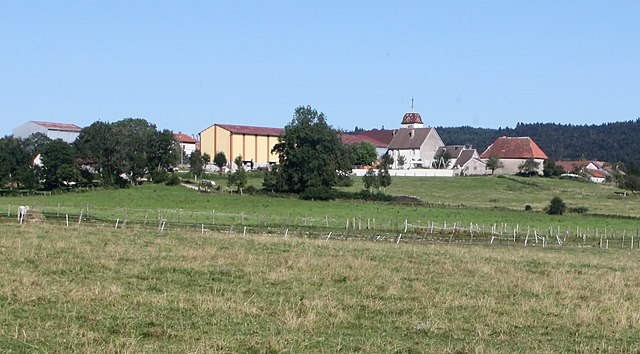
Valdahon (Valdahon)

- коммуна во Франции
 Hiking in Valdahon
Valdahon is a charming town located in the Doubs department in eastern France, surrounded by beautiful natural landscapes that provide excellent hiking opportunities. The region is characterized by rolling hills, forests, and picturesque valleys, making it a great destination for outdoor enthusiasts.
Hiking Trails
-
Circuit des Monts de Joux: This loop offers stunning views and varied terrain. You'll traverse through forests and meadows, with opportunities to spot local wildlife and enjoy panoramic vistas.
-
Sentier de l'Église: A shorter trail that’s perfect for families or those looking for a leisurely hike. It typically takes you through serene woodlands and might lead you to historical sites or local landmarks.
-
Les Chutes de la Saône: While not a long hike, this trail takes you to beautiful waterfalls and is a pleasant spot for a picnic or a break from hiking.
Seasonal Considerations
- Spring and Summer: The trails are lush and vibrant, filled with wildflowers. It’s a great time for birdwatching and enjoying the diverse plant life.
- Autumn: The fall colors transform the landscape, providing a stunning backdrop for your hikes.
- Winter: If you're into snowshoeing or winter hiking, the region offers some beautiful snowy trails, though you should check trail conditions and accessibility.
Tips for Hiking in Valdahon
- Maps and Navigation: Make sure to carry a detailed map or use a GPS device, as some trails might not be well-marked.
- Gear: Wear appropriate hiking boots and carry enough water, snacks, and a first-aid kit. The weather can change quickly, so dress in layers.
- Respect Nature: Follow the Leave No Trace principles to protect the beautiful environment.
Local Attractions
After a day of hiking, consider exploring Valdahon itself, where you can find local cuisine and perhaps visit historical sites like the Church of Saint-Étienne.
Whether you're looking for a challenging trek or a leisurely stroll, Valdahon offers a variety of trails that cater to all skill levels, rewarding hikers with breathtaking views and a chance to connect with nature. Enjoy your hiking adventure!
- Страна:

- Почтовый код: 25800
- Координаты: 47° 8' 59" N, 6° 20' 41" E


- GPS треки (wikiloc): [Ссылка]
- Площадь: 25.51 кв.км
- Население: 5474
- Веб сайт: http://www.valdahon.com
- Википедия английская: wiki(en)
- Википедия национальная: wiki(fr)
- Хранилище Wikidata: Wikidata: Q906787
- Катеория в википедии: [Ссылка]
- код Freebase: [/m/03mhdsz]
- код GeoNames: Альт: [6616241]
- номер SIREN: [212505788]
- код BNF: [152528049]
- код VIAF: Альт: [249428790]
- код муниципалитета INSEE: 25578
Граничит с регионами:


Épenoy
- коммуна во Франции
Hiking in Épenoy
Épenoy is a picturesque village located in the Bourgogne-Franche-Comté region of eastern France, nestled in the Jura Mountains. This area is known for its stunning landscapes, diverse flora and fauna, and a range of hiking opportunities suitable for various experience levels....
- Страна:
- Почтовый код: 25800
- Координаты: 47° 7' 52" N, 6° 22' 14" E
- GPS треки (wikiloc): [Ссылка]
- Площадь: 13.25 кв.км
- Население: 631


Étalans
- коммуна во Франции
Hiking in Étalans
Étalans is a charming village located in the Doubs department in the Bourgogne-Franche-Comté region of France. It is surrounded by beautiful natural landscapes, making it a great spot for hiking enthusiasts. Here are some highlights and tips for hiking in and around Étalans:...
- Страна:
- Почтовый код: 25580
- Координаты: 47° 9' 5" N, 6° 16' 6" E
- GPS треки (wikiloc): [Ссылка]
- Площадь: 23.95 кв.км
- Население: 1219
- Веб сайт: [Ссылка]


Étray
- коммуна во Франции
Hiking in Étray
Étray is a picturesque commune located in the Auvergne-Rhône-Alpes region of France, surrounded by stunning natural landscapes. While it may not be as widely known as some other hiking destinations, it offers a variety of trails and beautiful scenery that can make for an enjoyable hiking experience....
- Страна:
- Почтовый код: 25800
- Координаты: 47° 7' 23" N, 6° 20' 34" E
- GPS треки (wikiloc): [Ссылка]
- Площадь: 6 кв.км
- Население: 264


Verrières-du-Grosbois
- коммуна во Франции
Hiking in Verrières-du-Grosbois
Verrières-du-Grosbois, located in the Doubs department of France, is a beautiful region that offers various hiking opportunities. The area is characterized by its stunning natural landscapes, including rolling hills, dense forests, and panoramic views of the surrounding Jura Mountains. Here are some highlights for hiking in this region:...
- Страна:
- Почтовый код: 25580
- Координаты: 47° 12' 3" N, 6° 16' 37" E
- GPS треки (wikiloc): [Ссылка]
- Высота над уровнем моря: 599 м m
- Площадь: 7.86 кв.км
- Население: 34

Chevigney-lès-Vercel
- коммуна во Франции
Hiking in Chevigney-lès-Vercel
Chevigney-lès-Vercel is a charming commune located in the Doubs department of the Bourgogne-Franche-Comté region in eastern France. While it may not be one of the most famous hiking destinations, it offers a variety of scenic trails that showcase the beautiful landscapes of the region....
- Страна:
- Почтовый код: 25530
- Координаты: 47° 9' 49" N, 6° 22' 18" E
- GPS треки (wikiloc): [Ссылка]
- Высота над уровнем моря: 648 м m
- Площадь: 5.38 кв.км
- Население: 125


Fallerans
- коммуна во Франции
Hiking in Fallerans
It seems like there might be a typo or confusion regarding "Fallerans." As of my last training data, there isn’t a well-known hiking destination by that name. However, if you meant a different location or if it refers to a lesser-known or local area, I would be happy to help you with general information about hiking....
- Страна:
- Почтовый код: 25580
- Координаты: 47° 7' 56" N, 6° 17' 24" E
- GPS треки (wikiloc): [Ссылка]
- Площадь: 10.78 кв.км
- Население: 279


Vercel-Villedieu-le-Camp
- коммуна во Франции
Hiking in Vercel-Villedieu-le-Camp
Vercel-Villedieu-le-Camp is a charming commune located in the Drôme department of southeastern France, nestled in the stunning landscapes of the Auvergne-Rhône-Alpes region. The area is known for its scenic beauty, diverse terrain, and a variety of outdoor activities, making it a great destination for hiking enthusiasts....
- Страна:
- Почтовый код: 25530
- Координаты: 47° 11' 2" N, 6° 23' 57" E
- GPS треки (wikiloc): [Ссылка]
- Площадь: 29.96 кв.км
- Население: 1540
- Веб сайт: [Ссылка]