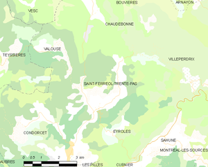
Valouse (Valouse)

- коммуна во Франции
 Hiking in Valouse
Valouse is not widely recognized as a hiking destination, and there may be a chance that you meant another location. However, if you're referring to a specific region or trail that might be lesser-known, I can provide general hiking tips and considerations.
If you're planning to hike in an area called Valouse or a similar-sounding location, here are some general suggestions for preparation:
-
Research Local Trails: Look for local trails, parks, or natural reserves that may be in the region. Websites like AllTrails, local government or tourism sites can offer maps, difficulty ratings, and user reviews.
-
Check Trail Conditions: Before heading out, check current trail conditions and any weather forecasts. This can help you dress appropriately and prepare for any obstacles you might encounter.
-
Plan Your Route: Choose a trail that matches your fitness level and experience. Make a plan for how long you'll hike and when you'll start and finish to ensure you have plenty of daylight.
-
Pack Essentials: Bring water, snacks, a first-aid kit, navigation tools (like a map or GPS), appropriate clothing, and any necessary hiking gear.
-
Safety Considerations: Always let someone know your hiking plans, especially if you're hiking in remote areas. Be aware of wildlife, and know how to store food properly if you're in bear country.
-
Leave No Trace: Follow Leave No Trace principles to minimize your impact on the environment. This includes packing out what you pack in, staying on trails, and respecting wildlife.
If you provide me with more details or clarify the location you’re interested in, I can offer more specific guidance about that area!
- Страна:

- Почтовый код: 26110
- Координаты: 44° 27' 47" N, 5° 11' 32" E


- GPS треки (wikiloc): [Ссылка]
- Площадь: 6.33 кв.км
- Население: 33
- Википедия английская: wiki(en)
- Википедия национальная: wiki(fr)
- Хранилище Wikidata: Wikidata: Q266072
- Катеория в википедии: [Ссылка]
- код Freebase: [/m/03mhlst]
- код GeoNames: Альт: [6430261]
- номер SIREN: [212603633]
- код BNF: [152532235]
- код муниципалитета INSEE: 26363
Граничит с регионами:
Teyssières
- коммуна во Франции
Hiking in Teyssières
Teyssières is a beautiful area located in the Drôme department of France, known for its stunning natural landscapes and outdoor activities, including hiking. Hiking in Teyssières offers a variety of trails that cater to different skill levels, making it a great destination for both novice and experienced hikers....
- Страна:
- Почтовый код: 26220
- Координаты: 44° 27' 41" N, 5° 8' 45" E
- GPS треки (wikiloc): [Ссылка]
- Площадь: 28.09 кв.км
- Население: 82


Vesc
- коммуна во Франции
Hiking in Vesc
Vesc, a charming village in the Drôme region of southeastern France, is surrounded by beautiful landscapes that offer excellent hiking opportunities. The area is known for its picturesque hills, forests, and vibrant agricultural lands, making it perfect for outdoor enthusiasts....
- Страна:
- Почтовый код: 26220
- Координаты: 44° 31' 19" N, 5° 9' 3" E
- GPS треки (wikiloc): [Ссылка]
- Площадь: 40.48 кв.км
- Население: 283


Chaudebonne
- коммуна во Франции
Hiking in Chaudebonne
Chaudebonne, located in the picturesque region of the French Alps, offers some stunning hiking opportunities. The area is known for its breathtaking mountain scenery, lush valleys, and diverse wildlife. Here are a few highlights to consider when planning a hike in this region:...
- Страна:
- Почтовый код: 26110
- Координаты: 44° 28' 36" N, 5° 13' 7" E
- GPS треки (wikiloc): [Ссылка]
- Площадь: 20.77 кв.км
- Население: 53

Saint-Ferréol-Trente-Pas
- коммуна во Франции
Hiking in Saint-Ferréol-Trente-Pas
Saint-Ferréol-Trente-Pas is located in the beautiful region of Occitanie in France, nestled in the foothills of the Pyrenees. The area offers a variety of hiking opportunities for both beginners and experienced hikers. Here's what you can expect when hiking in and around Saint-Ferréol-Trente-Pas:...
- Страна:
- Почтовый код: 26110
- Координаты: 44° 25' 37" N, 5° 13' 3" E
- GPS треки (wikiloc): [Ссылка]
- Площадь: 21.48 кв.км
- Население: 236