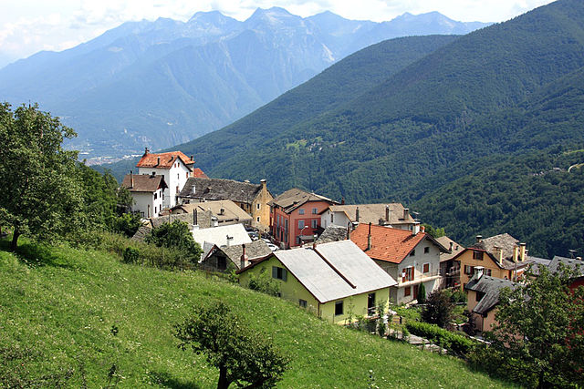
Варцо (Varzo, Varzo)
- коммуна Италии
 Hiking in Варцо
Varzo, located in the Piedmont region of Italy, is a beautiful destination for hiking enthusiasts. Nestled in the Val Divedro and surrounded by the breathtaking peaks of the Lepontine Alps, it offers a variety of trails that cater to different skill levels, from beginners to advanced hikers.
Key Attractions and Trails:
-
Natural Beauty: The area is characterized by stunning landscapes, including lush forests, alpine meadows, and panoramic views of the surrounding mountains. The rich biodiversity makes it an ideal spot for nature lovers.
-
Monte Leone: One of the prominent peaks in the area, Monte Leone offers a challenging hike with rewarding views at the summit. The trail typically starts from Varzo and takes you through scenic paths leading up to the mountain.
-
Val Divedro: This valley boasts several well-marked trails suitable for various levels of hikers. The path often follows the river, providing opportunities to enjoy the sound of rushing water and spot local wildlife.
-
Historic Routes: Some trails in the Varzo area are steeped in history, featuring old military paths from World War I or routes utilized by traders and shepherds. These paths not only provide a hiking challenge but also a glimpse into the region’s past.
-
Waterfalls and Lakes: The region is home to numerous waterfalls and alpine lakes, such as the Lago di Saas. These sites are perfect for a scenic break during a hike and provide excellent photographic opportunities.
Tips for Hiking in Varzo:
- Navigational Tools: While most trails are marked, it's advisable to carry a map or use a GPS device, especially when venturing into more remote areas.
- Weather Considerations: The weather can change rapidly in the mountains. Check forecasts before heading out and pack appropriate clothing for varying conditions.
- Hydration and Snacks: Ensure you bring enough water and snacks, especially on longer hikes, as facilities may be limited in the wilderness.
- Local Regulations: Respect nature and follow local guidelines, such as staying on marked paths and following fire safety regulations.
- Wildlife Awareness: Be aware of the local wildlife and maintain a safe distance if you encounter any animals.
Best Time to Hike:
The optimal time for hiking in Varzo is late spring through early autumn (May to October) when the weather is generally more stable, and the trails are clear of snow. In summer, the area comes alive with blooming flowers and vibrant greenery.
Whether you're looking for a leisurely stroll or a challenging climb, Varzo's hiking trails offer something for everyone and an unforgettable experience in the heart of the Alps!
- Страна:

- Почтовый код: 28868
- Телефонный код: 0324
- Код автомобильного номера: VB
- Координаты: 46° 12' 27" N, 8° 15' 12" E


- GPS треки (wikiloc): [Ссылка]
- Высота над уровнем моря: 568 м m
- Площадь: 93.77 кв.км
- Население: 2031
- Веб сайт: http://www.comune.varzo.vb.it/
- Википедия русская: wiki(ru)
- Википедия английская: wiki(en)
- Википедия национальная: wiki(it)
- Хранилище Wikidata: Wikidata: Q23713
- Катеория в википедии: [Ссылка]
- код Freebase: [/m/0gr938]
- код GeoNames: Альт: [6538036]
- код VIAF: Альт: [242326961]
- ID отношения в OpenStreetMap: [47011]
- код ISTAT: 103071
- кадастровый код Италии: L691
Граничит с регионами:

Бачено
- коммуна Италии
Hiking in Бачено
Baceno is a charming village located in the Piedmont region of northern Italy, nestled in the Ossola Valley. This area is known for its beautiful landscapes, rich history, and a variety of hiking trails suitable for different skill levels. Here are some highlights about hiking in Baceno:...
- Страна:
- Почтовый код: 28861
- Телефонный код: 0324
- Код автомобильного номера: VB
- Координаты: 46° 16' 0" N, 8° 19' 0" E
- GPS треки (wikiloc): [Ссылка]
- Высота над уровнем моря: 655 м m
- Площадь: 77.27 кв.км
- Население: 900
- Веб сайт: [Ссылка]
Боньянко
- коммуна Италии
Hiking in Боньянко
Bognanco is a charming village located in the Ossola Valley in the Piedmont region of Italy, known for its beautiful natural landscapes and rich cultural heritage. Hiking in and around Bognanco can be a wonderful experience, thanks to its scenic trails, lush forests, and stunning mountain views....
- Страна:
- Почтовый код: 28042
- Телефонный код: 0324
- Код автомобильного номера: VB
- Координаты: 46° 7' 34" N, 8° 12' 0" E
- GPS треки (wikiloc): [Ссылка]
- Высота над уровнем моря: 980 м m
- Площадь: 58 кв.км
- Население: 200
- Веб сайт: [Ссылка]

Креволадоссола
- коммуна Италии
Hiking in Креволадоссола
Crevoladossola is a charming town located in the Piedmont region of northern Italy, nestled at the entrance to the Val Vigezzo, surrounded by stunning Alpine scenery. The area offers a variety of hiking opportunities that cater to different skill levels, from leisurely walks to more challenging treks....
- Страна:
- Почтовый код: 28865
- Телефонный код: 0324
- Код автомобильного номера: VB
- Координаты: 46° 10' 0" N, 8° 18' 0" E
- GPS треки (wikiloc): [Ссылка]
- Высота над уровнем моря: 375 м m
- Площадь: 39.87 кв.км
- Население: 4600
- Веб сайт: [Ссылка]

Кродо
- коммуна Италии
Hiking in Кродо
Crodo is a charming village located in the Piedmont region of northern Italy, nestled within the beautiful valleys of the Ossola Alps. The area surrounding Crodo offers a variety of hiking opportunities for all levels of outdoor enthusiasts. Here are some things to consider for hiking in and around Crodo:...
- Страна:
- Почтовый код: 28862
- Телефонный код: 0324
- Код автомобильного номера: VB
- Координаты: 46° 13' 21" N, 8° 19' 27" E
- GPS треки (wikiloc): [Ссылка]
- Высота над уровнем моря: 525 м m
- Площадь: 53.58 кв.км
- Население: 1400
- Веб сайт: [Ссылка]
Траскуера
- коммуна Италии
Hiking in Траскуера
Trasquera is a charming village located in the Piedmont region of Italy, specifically in the Val d'Ossola. It's surrounded by stunning natural landscapes, making it a great destination for hiking enthusiasts. Here are some key aspects of hiking in Trasquera:...
- Страна:
- Почтовый код: 28868
- Телефонный код: 0324
- Код автомобильного номера: VB
- Координаты: 46° 8' 0" N, 8° 12' 0" E
- GPS треки (wikiloc): [Ссылка]
- Высота над уровнем моря: 1100 м m
- Площадь: 39.6 кв.км
- Население: 178
- Веб сайт: [Ссылка]


Grengiols
Hiking in Grengiols
Grengiols is a charming village located in the Valais region of Switzerland, known for its stunning landscapes and diverse hiking opportunities. Nestled in the mountains, it offers a unique blend of natural beauty, traditional Swiss architecture, and a peaceful atmosphere. Here are some key points about hiking in Grengiols:...
- Страна:

- Почтовый код: 3993
- Телефонный код: 027
- Код автомобильного номера: VS
- Координаты: 46° 22' 0" N, 8° 6' 0" E
- GPS треки (wikiloc): [Ссылка]
- Высота над уровнем моря: 984 м m
- Площадь: 58.46 кв.км
- Население: 432
- Веб сайт: [Ссылка]

Рид-Бриг
Hiking in Рид-Бриг
Ried-Brig is a charming village located in the Valais region of Switzerland, surrounded by stunning natural landscapes and offering excellent hiking opportunities. Here are some highlights for hiking in the area:...
- Страна:
- Почтовый код: 3911
- Телефонный код: 027
- Код автомобильного номера: VS
- Координаты: 46° 19' 0" N, 8° 1' 0" E
- GPS треки (wikiloc): [Ссылка]
- Высота над уровнем моря: 918 м m
- Площадь: 47.53 кв.км
- Население: 2092
- Веб сайт: [Ссылка]


Zwischbergen
Hiking in Zwischbergen
Zwischbergen, located in the Swiss Alps near the village of Simplon in the Valais region, is known for its stunning landscapes and excellent hiking opportunities. Here are some key highlights about hiking in Zwischbergen:...
- Страна:
- Почтовый код: 3901
- Код автомобильного номера: VS
- Координаты: 46° 10' 0" N, 8° 7' 0" E
- GPS треки (wikiloc): [Ссылка]
- Высота над уровнем моря: 1322 м m
- Площадь: 86.1 кв.км
- Население: 77
- Веб сайт: [Ссылка]