Бачено (Baceno, Baceno)
- коммуна Италии
 Hiking in Бачено
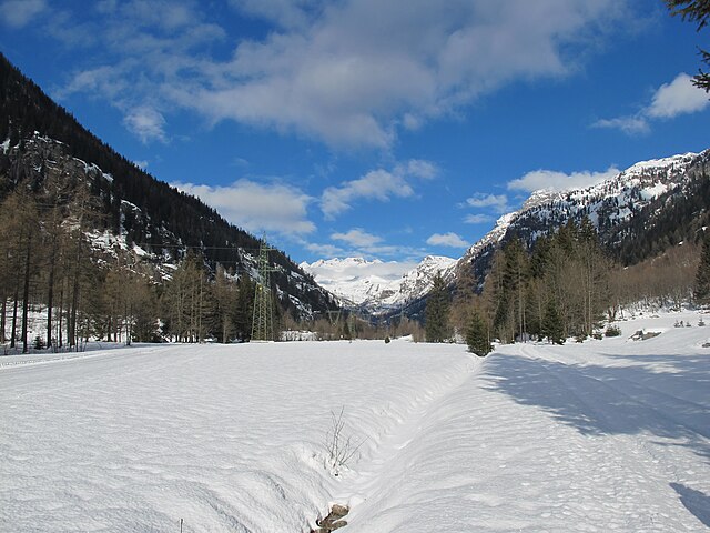
Baceno is a charming village located in the Piedmont region of northern Italy, nestled in the Ossola Valley. This area is known for its beautiful landscapes, rich history, and a variety of hiking trails suitable for different skill levels. Here are some highlights about hiking in Baceno:
Trails and Routes
-
Sentiero del Sole (Sun Trail): This scenic route offers breathtaking views of the surrounding mountains and valleys. It's suitable for families and less experienced hikers, featuring well-marked paths.
-
Lago delle Fate: A beautiful lake that can be reached via a moderate hike. The trail takes you through lush forests and provides stunning views of the alpine landscape. It's a great spot for a picnic.
-
Monte Zeda: For more experienced hikers, the ascent to Monte Zeda is rewarding, offering panoramic views of the Ossola Valley and the surrounding peaks. The trail can be challenging, so proper gear and preparation are essential.
-
Valle Antrona: This area is known for its diverse flora and fauna. The trails are typically less crowded and provide a great opportunity to experience the natural beauty of the region.
Best Time to Hike
The best time for hiking in Baceno is during the spring and fall when temperatures are mild, and the views are particularly stunning. Summer can be warm, but it’s also the most popular hiking season.
Accessibility
Baceno is accessible by car, and once there, many trailheads can be reached on foot or a short drive. It’s advisable to check local maps and guides for the most current trail conditions and accessibility.
Local Tips
- Gear Up: Wear proper hiking boots, and bring along a backpack with water, snacks, and a first-aid kit.
- Stay Safe: Always inform someone of your hiking plans and stick to marked trails. Weather can change quickly in the mountains.
- Respect Nature: Leave no trace by picking up after yourself and respecting wildlife.
Culture and Amenities
Baceno is not only a place for outdoor adventures but also has a rich history and culture to explore. Don’t miss out on sampling local cuisine in the village's restaurants after a day of hiking.
Whether you're looking for a peaceful walk in nature or a challenging climb, Baceno has something to offer for every hiking enthusiast!
- Страна:

- Почтовый код: 28861
- Телефонный код: 0324
- Код автомобильного номера: VB
- Координаты: 46° 16' 0" N, 8° 19' 0" E


- GPS треки (wikiloc): [Ссылка]
- Высота над уровнем моря: 655 м m
- Площадь: 77.27 кв.км
- Население: 900
- Веб сайт: http://www.comune.baceno.vb.it
- Википедия русская: wiki(ru)
- Википедия английская: wiki(en)
- Википедия национальная: wiki(it)
- Хранилище Wikidata: Wikidata: Q23226
- Катеория в википедии: [Ссылка]
- код Freebase: [/m/0gr7t2]
- код GeoNames: Альт: [6539440]
- код VIAF: Альт: [236580517]
- ID отношения в OpenStreetMap: [47097]
- код ISTAT: 103006
- кадастровый код Италии: A534
Граничит с регионами:

Кродо
- коммуна Италии
Hiking in Кродо
Crodo is a charming village located in the Piedmont region of northern Italy, nestled within the beautiful valleys of the Ossola Alps. The area surrounding Crodo offers a variety of hiking opportunities for all levels of outdoor enthusiasts. Here are some things to consider for hiking in and around Crodo:...
- Страна:
- Почтовый код: 28862
- Телефонный код: 0324
- Код автомобильного номера: VB
- Координаты: 46° 13' 21" N, 8° 19' 27" E
- GPS треки (wikiloc): [Ссылка]
- Высота над уровнем моря: 525 м m
- Площадь: 53.58 кв.км
- Население: 1400
- Веб сайт: [Ссылка]
Формацца
- коммуна Италии
Hiking in Формацца
Formazza, located in the northeastern part of Italy's Piedmont region, is a beautiful area renowned for its stunning landscapes, alpine scenery, and rich cultural heritage, making it an exceptional hiking destination. Here are some key points about hiking in Formazza:...
- Страна:
- Почтовый код: 28863
- Телефонный код: 0324
- Код автомобильного номера: VB
- Координаты: 46° 23' 0" N, 8° 26' 0" E
- GPS треки (wikiloc): [Ссылка]
- Высота над уровнем моря: 1280 м m
- Площадь: 130.65 кв.км
- Население: 442
- Веб сайт: [Ссылка]

Премиа
- коммуна Италии
Hiking in Премиа
Premia, a town located in the province of Barcelona, Spain, offers beautiful landscapes and opportunities for hiking enthusiasts. The area is characterized by its scenic views, forests, and proximity to both the mountains and the Mediterranean coast....
- Страна:
- Почтовый код: 28866
- Телефонный код: 0324
- Код автомобильного номера: VB
- Координаты: 46° 16' 0" N, 8° 20' 0" E
- GPS треки (wikiloc): [Ссылка]
- Высота над уровнем моря: 800 м m
- Площадь: 88.9 кв.км
- Население: 557
- Веб сайт: [Ссылка]

Варцо
- коммуна Италии
Hiking in Варцо
Varzo, located in the Piedmont region of Italy, is a beautiful destination for hiking enthusiasts. Nestled in the Val Divedro and surrounded by the breathtaking peaks of the Lepontine Alps, it offers a variety of trails that cater to different skill levels, from beginners to advanced hikers....
- Страна:
- Почтовый код: 28868
- Телефонный код: 0324
- Код автомобильного номера: VB
- Координаты: 46° 12' 27" N, 8° 15' 12" E
- GPS треки (wikiloc): [Ссылка]
- Высота над уровнем моря: 568 м m
- Площадь: 93.77 кв.км
- Население: 2031
- Веб сайт: [Ссылка]


Grengiols
Hiking in Grengiols
Grengiols is a charming village located in the Valais region of Switzerland, known for its stunning landscapes and diverse hiking opportunities. Nestled in the mountains, it offers a unique blend of natural beauty, traditional Swiss architecture, and a peaceful atmosphere. Here are some key points about hiking in Grengiols:...
- Страна:

- Почтовый код: 3993
- Телефонный код: 027
- Код автомобильного номера: VS
- Координаты: 46° 22' 0" N, 8° 6' 0" E
- GPS треки (wikiloc): [Ссылка]
- Высота над уровнем моря: 984 м m
- Площадь: 58.46 кв.км
- Население: 432
- Веб сайт: [Ссылка]

Binn
Hiking in Binn
Binn is a small village located in the picturesque Val Binn in the Swiss Alps, specifically in the Canton of Valais. It’s known for its stunning natural beauty and is a great spot for hiking enthusiasts. Here’s what you should know about hiking in Binn:...
- Страна:
- Почтовый код: 3996
- Телефонный код: 027
- Код автомобильного номера: VS
- Координаты: 46° 22' 0" N, 8° 11' 0" E
- GPS треки (wikiloc): [Ссылка]
- Высота над уровнем моря: 1400 м m
- Площадь: 65.0 кв.км
- Население: 140
- Веб сайт: [Ссылка]