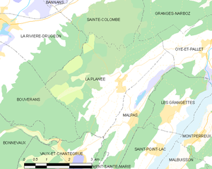
Vaux-et-Chantegrue (Vaux-et-Chantegrue)

- коммуна во Франции
 Hiking in Vaux-et-Chantegrue
Vaux-et-Chantegrue is a charming village in the Jura region of France, known for its picturesque landscapes, rolling hills, and tranquil natural surroundings. The area offers several hiking opportunities that allow you to explore its beauty.
Hiking Trails
-
Local Trails: Vaux-et-Chantegrue has various marked trails suitable for hikers of different skill levels. These trails often weave through forests, and pastures, and provide breathtaking views of the Jura mountains.
-
Sentier des Cimes: A popular trail that offers scenic overlooks and a chance to experience the diverse flora and fauna of the region.
-
Circuit de la Vigne: This trail takes you through vineyards and rural landscapes, giving you a taste of the local culture and agricultural practices.
Flora and Fauna
The Jura region is rich in biodiversity. While hiking, you might see a variety of wildlife, including deer, foxes, and numerous bird species. The flora is equally diverse, making spring and summer an especially beautiful time to hike.
Best Times to Hike
- Spring: Flowers bloom, and the weather is mild, making it perfect for hiking.
- Summer: Ideal for longer hikes and enjoying the lush landscapes.
- Autumn: The changing foliage offers stunning views and a peaceful hiking experience.
- Winter: While some trails may be covered in snow, there are opportunities for winter hiking and snowshoeing in the region.
Tips
- Footwear: Wear sturdy hiking boots with good grip, as trails can be uneven and rocky.
- Water and Snacks: Carry plenty of water and snacks, especially for longer hikes.
- Maps: It’s a good idea to have a map or a GPS device, as some trails might not be well-marked.
- Respect Nature: Stay on marked paths and carry out any trash to maintain the beauty of the area.
Additional Activities
Besides hiking, the region offers opportunities for cycling, bird watching, and even visiting local wineries.
Enjoy your adventure in Vaux-et-Chantegrue! Always check local resources for trail conditions and any potential closures before you set out.
- Страна:

- Почтовый код: 25160
- Координаты: 46° 48' 39" N, 6° 14' 59" E


- GPS треки (wikiloc): [Ссылка]
- Площадь: 13.98 кв.км
- Население: 544
- Википедия английская: wiki(en)
- Википедия национальная: wiki(fr)
- Хранилище Wikidata: Wikidata: Q768094
- Катеория в википедии: [Ссылка]
- код Freebase: [/m/03mgbmy]
- код GeoNames: Альт: [6430034]
- номер SIREN: [212505929]
- код BNF: [152528180]
- код муниципалитета INSEE: 25592
Граничит с регионами:


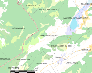
Mignovillard
- коммуна во Франции
Hiking in Mignovillard
Mignovillard, located in the Jura department of France, is a charming destination for hiking enthusiasts. Nestled in the foothills of the Jura Mountains, it offers a variety of trails that cater to different skill levels, from leisurely walks to more challenging hikes....
- Страна:
- Почтовый код: 39250
- Координаты: 46° 47' 29" N, 6° 7' 33" E
- GPS треки (wikiloc): [Ссылка]
- Площадь: 49.81 кв.км
- Население: 743
- Веб сайт: [Ссылка]


Bonnevaux
Hiking in Bonnevaux
Bonnevaux is a beautiful area located in the Doubs department of the Bourgogne-Franche-Comté region in eastern France. It's known for its stunning natural landscapes, lush forests, and serene environment, making it a great destination for hiking enthusiasts....
- Страна:
- Почтовый код: 25560
- Координаты: 46° 48' 30" N, 6° 11' 7" E
- GPS треки (wikiloc): [Ссылка]
- Площадь: 16.53 кв.км
- Население: 375


Bouverans
- коммуна во Франции
Hiking in Bouverans
Bouverans is a picturesque village located in the Franche-Comté region of France, not far from the Doubs River. While it may not be as widely known as some other hiking destinations, it offers access to beautiful natural scenery and hiking opportunities in the surrounding Jura Mountains and countryside....
- Страна:
- Почтовый код: 25560
- Координаты: 46° 51' 12" N, 6° 12' 29" E
- GPS треки (wikiloc): [Ссылка]
- Площадь: 18.17 кв.км
- Население: 356
- Веб сайт: [Ссылка]

La Planée
- коммуна во Франции
Hiking in La Planée
Hiking in La Planée, located in the French Alps, offers stunning landscapes and diverse trails suitable for different skill levels. The area is known for its picturesque views, ranging from sweeping valleys to rugged mountain peaks....
- Страна:
- Почтовый код: 25160
- Координаты: 46° 50' 25" N, 6° 16' 55" E
- GPS треки (wikiloc): [Ссылка]
- Площадь: 13 кв.км
- Население: 261


Malpas
- коммуна во Франции
Hiking in Malpas
Malpas, located in the Doubs department of France, is a picturesque area known for its natural beauty and outdoor activities, including hiking. The Doubs region is characterized by its varied landscapes, including rolling hills, dense forests, and the winding Doubs River. Here are some key points to consider when hiking in Malpas and its surroundings:...
- Страна:
- Почтовый код: 25160
- Координаты: 46° 49' 35" N, 6° 17' 22" E
- GPS треки (wikiloc): [Ссылка]
- Площадь: 5.78 кв.км
- Население: 273

Remoray-Boujeons
- коммуна во Франции
Hiking in Remoray-Boujeons
Remoray-Boujeons, located in the Jura Mountains of France, offers a variety of hiking opportunities that are perfect for outdoor enthusiasts of all levels. This region is known for its beautiful landscapes, rich biodiversity, and serene lakes. Here are some key points to consider when planning a hike in the area:...
- Страна:
- Почтовый код: 25160
- Координаты: 46° 46' 3" N, 6° 14' 20" E
- GPS треки (wikiloc): [Ссылка]
- Площадь: 15.15 кв.км
- Население: 412
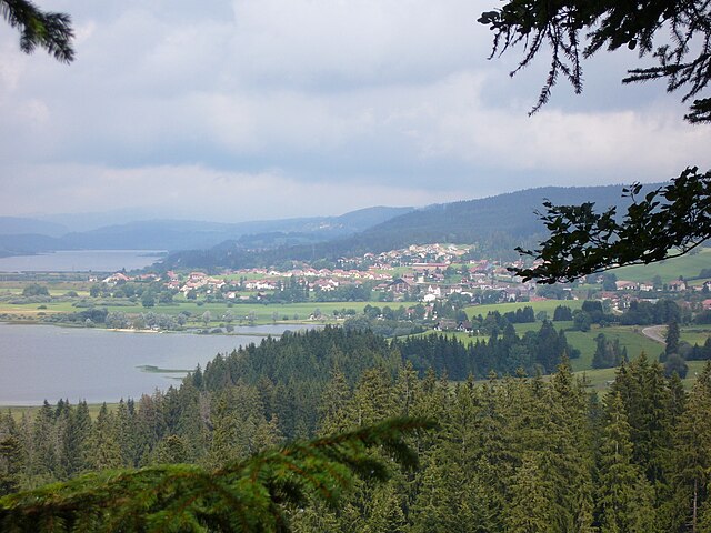

Labergement-Sainte-Marie
- коммуна во Франции
Hiking in Labergement-Sainte-Marie
Labergement-Sainte-Marie is a charming village located in the Doubs department of the Bourgogne-Franche-Comté region in eastern France. Nestled in the heart of the Jura Mountains, it offers beautiful landscapes, rich flora and fauna, and a variety of hiking opportunities suitable for different skill levels....
- Страна:
- Почтовый код: 25160
- Координаты: 46° 46' 29" N, 6° 16' 50" E
- GPS треки (wikiloc): [Ссылка]
- Площадь: 22.12 кв.км
- Население: 1160