
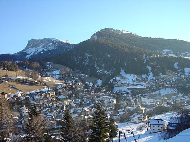
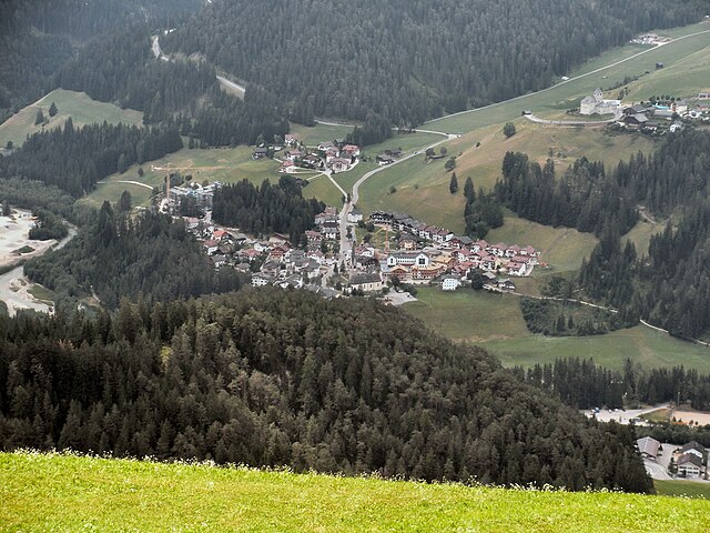
Санта-Кристина-Вальгардена (Santa Cristina Gherdëina, Santa Cristina Valgardena)
.svg)
- коммуна в Италии
 Hiking in Санта-Кристина-Вальгардена
Santa Cristina Gherdëina, located in the Dolomites of northern Italy, is a beautiful destination for hiking enthusiasts. The stunning landscape, dramatic peaks, and vibrant alpine scenery provide an incredible backdrop for a variety of hiking trails, suitable for all skill levels. Here are some highlights and tips if you’re considering hiking in this region:
Trail Options
-
Seceda Plateau: You can access this area via a cable car from Santa Cristina. The plateau offers several hiking trails that provide panoramic views of the surrounding Dolomites. The area is relatively flat, making it suitable for families and beginners.
-
Val Gardena Trail: This trail connects various villages in the Val Gardena area and showcases the stunning landscapes unique to this region. It is generally well-marked and offers options for shorter or longer hikes.
-
Sasso Lungo: For more experienced hikers, the Sasso Lungo circuit is breathtaking. The trail takes you around the Sasso Lungo massif, offering some stunning views of the peaks and valleys.
-
Puez-Odle Nature Park: This park features various trails that wind through breathtaking meadows, forests, and rocky terrain. Trails here suit various levels, and the park is rich in biodiversity.
Best Time to Hike
- Summer (June to September): The most popular time for hiking when the weather is warm and the trails are fully accessible.
- Autumn (October): This season provides stunning fall colors, but be aware that some trails might close as weather starts to change.
Tips for Hiking in Santa Cristina Gherdëina
- Weather Awareness: The weather in the mountains can change rapidly. Always check the forecast before heading out.
- Proper Gear: Wear sturdy hiking boots, and consider layering your clothing to adapt to changing conditions.
- Water and Snacks: Bring plenty of water and snacks, especially for longer hikes. Some trails may have limited amenities.
- Navigation: Familiarize yourself with trail maps and possibly download offline maps, as cell service can be spotty in mountainous areas.
- Respect Nature: Stay on marked trails, follow wildlife regulations, and practice Leave No Trace principles.
Safety Considerations
- Always let someone know your hiking plans.
- If you're hiking alone, choose well-marked trails and inform local hiking guides or tourist offices for recommendations.
- Be cautious of your physical limits, especially in more challenging terrains.
Conclusion
Santa Cristina Gherdëina offers a magical hiking experience with its stunning landscapes and variety of trails. Whether you're a beginner or an experienced hiker, this beautiful area in the Dolomites is sure to provide a memorable adventure.
- Страна:

- Почтовый код: 39047
- Телефонный код: 0471
- Код автомобильного номера: BZ
- Координаты: 46° 33' 47" N, 11° 43' 56" E


- GPS треки (wikiloc): [Ссылка]
- Высота над уровнем моря: 1428 м m
- Площадь: 31.92 кв.км
- Население: 1961
- Веб сайт: http://www.comune.santacristina.bz.it/
- Википедия русская: wiki(ru)
- Википедия английская: wiki(en)
- Википедия национальная: wiki(it)
- Хранилище Wikidata: Wikidata: Q504253
- Галерея изображений в википедии: [Ссылка]
- Катеория в википедии: [Ссылка]
- код Freebase: [/m/0g9jv8]
- код GeoNames: Альт: [6535979]
- код VIAF: Альт: [235666554]
- ID отношения в OpenStreetMap: [47244]
- код GND: Альт: [4528625-5]
- код ISTAT: 021085
- кадастровый код Италии: I173
Граничит с регионами:

Ортизеи
- коммуна Италии
Hiking in Ортизеи
Urtijëi, also known as Ortisei, is a charming village located in the Val Gardena valley in South Tyrol, Italy. It's a popular base for hiking enthusiasts due to its stunning scenery, diverse trails, and proximity to the Dolomites, a UNESCO World Heritage site. Here are some highlights and tips for hiking in the Urtijëi area:...
- Страна:
- Почтовый код: 39046
- Телефонный код: 0471
- Код автомобильного номера: BZ
- Координаты: 46° 34' 0" N, 11° 40' 0" E
- GPS треки (wikiloc): [Ссылка]
- Высота над уровнем моря: 1230 м m
- Площадь: 24.16 кв.км
- Население: 4883
- Веб сайт: [Ссылка]


Кампителло-ди-Фасса
- коммуна Италии
Hiking in Кампителло-ди-Фасса
Campitello di Fassa, located in the Dolomites in northern Italy, is a picturesque destination for hiking enthusiasts. Surrounded by stunning mountain landscapes, lush forests, and vibrant meadows, it offers a variety of trails suitable for hikers of all skill levels....
- Страна:
- Почтовый код: 38031
- Телефонный код: 0462
- Код автомобильного номера: TN
- Координаты: 46° 28' 36" N, 11° 44' 28" E
- GPS треки (wikiloc): [Ссылка]
- Высота над уровнем моря: 1448 м m
- Площадь: 25.02 кв.км
- Население: 730
- Веб сайт: [Ссылка]

Фунес
- коммуна Италии
Hiking in Фунес
Villnöß, or Villnöß Valley, is a beautiful hiking destination located in South Tyrol, Northern Italy. Nestled at the foot of the Dolomites, it offers stunning landscapes, diverse trails, and an opportunity to experience both nature and local culture. Here are some highlights about hiking in this picturesque area:...
- Страна:
- Почтовый код: 39040
- Телефонный код: 0472
- Код автомобильного номера: BZ
- Координаты: 46° 38' 34" N, 11° 40' 42" E
- GPS треки (wikiloc): [Ссылка]
- Высота над уровнем моря: 1132 м m
- Площадь: 81.38 кв.км
- Население: 2603
- Веб сайт: [Ссылка]


Кастельротто
- коммуна Италии
Hiking in Кастельротто
Kastelruth, located in the beautiful Dolomites region of northern Italy, is a fantastic destination for hiking enthusiasts. The area is known for its stunning landscapes, diverse trails, and charming alpine villages. Here are some highlights and tips for hiking in Kastelruth:...
- Страна:
- Почтовый код: 39040
- Телефонный код: 0471
- Код автомобильного номера: BZ
- Координаты: 46° 34' 0" N, 11° 33' 40" E
- GPS треки (wikiloc): [Ссылка]
- Высота над уровнем моря: 2958 м m
- Площадь: 117.9 кв.км
- Население: 6872
- Веб сайт: [Ссылка]

Сан-Мартино-ин-Бадия
- коммуна в Италии
Hiking in Сан-Мартино-ин-Бадия
San Martin de Tor, located in the Dolomites of Northern Italy, is an excellent destination for hiking enthusiasts. The area is known for its stunning landscapes, rich cultural heritage, and a variety of trails that cater to different skill levels. Here are some highlights and tips for hiking in and around San Martin de Tor:...
- Страна:
- Почтовый код: 39030
- Телефонный код: 0474
- Код автомобильного номера: BZ
- Координаты: 46° 40' 54" N, 11° 53' 53" E
- GPS треки (wikiloc): [Ссылка]
- Высота над уровнем моря: 1127 м m
- Площадь: 75.94 кв.км
- Население: 1744
- Веб сайт: [Ссылка]

Сельва-ди-Валь-Гардена
- коммуна в Италии
Hiking in Сельва-ди-Валь-Гардена
Sëlva, known as Selva di Val Gardena, is a picturesque village located in the Dolomites of northern Italy, particularly popular for its stunning landscapes and diverse hiking trails. The Dolomites are a UNESCO World Heritage site, making hiking in this region an unforgettable experience....
- Страна:
- Почтовый код: 39048
- Телефонный код: 0471
- Код автомобильного номера: BZ
- Координаты: 46° 33' 17" N, 11° 45' 37" E
- GPS треки (wikiloc): [Ссылка]
- Высота над уровнем моря: 1563 м m
- Площадь: 56.24 кв.км
- Население: 2621
- Веб сайт: [Ссылка]