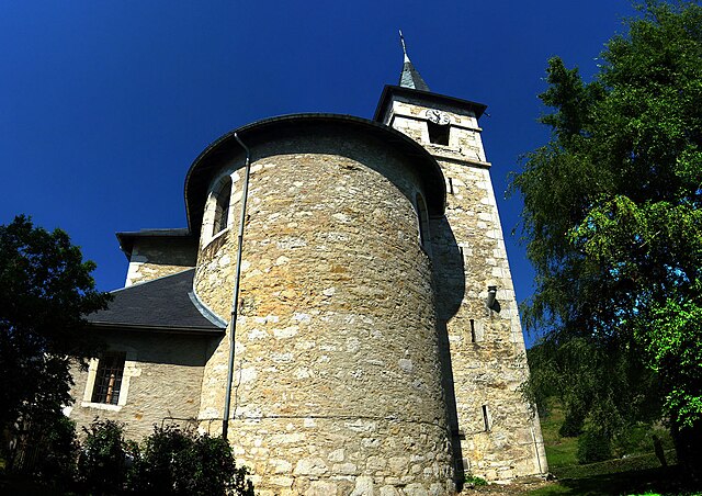
Vimines (Vimines)

- коммуна во Франции
 Hiking in Vimines
It seems that Vimines might be a lesser-known location, as it doesn't appear in common hiking resources or databases. However, if you have a specific area in mind, such as a town or region near Vimines, I can offer general hiking advice or information on nearby hiking trails.
If Vimines refers to a location in the French Alps or the region of Savoie, that area is known for its beautiful landscapes and numerous hiking trails. Here are some general tips and information for hiking in such mountainous terrains:
-
Trail Selection: Depending on your experience level, you can find trails that range from easy walks to challenging hikes. Always check local guides or hiking apps for trail difficulty ratings.
-
Weather Preparedness: The weather can change rapidly in mountainous areas. Make sure to check the forecast before you set out and be prepared for sudden weather changes.
-
Gear Up: Wear sturdy hiking boots, bring plenty of water, and pack snacks. If you’re hiking in colder months, layers are essential, as temperatures can drop significantly.
-
Wildlife: Be aware of local wildlife. In some regions, you may encounter animals such as deer or, in certain areas, even bears. Know how to interact safely with wildlife.
-
Navigation: Familiarize yourself with the area’s maps and trail markers. In less populated areas, a GPS device or hiking app can be invaluable.
-
Leave No Trace: Respect the natural environment by following the Leave No Trace principles. This includes packing out what you bring in, staying on marked trails, and not disturbing wildlife.
If you provide more specific details about Vimines or the surrounding area, I can offer more tailored advice or information on specific hiking trails!
- Страна:

- Почтовый код: 73160
- Координаты: 45° 32' 44" N, 5° 51' 54" E


- GPS треки (wikiloc): [Ссылка]
- Площадь: 14.23 кв.км
- Население: 1965
- Веб сайт: http://www.vimines.com
- Википедия английская: wiki(en)
- Википедия национальная: wiki(fr)
- Хранилище Wikidata: Wikidata: Q1216961
- Катеория в википедии: [Ссылка]
- код Freebase: [/m/03npgvg]
- код GeoNames: Альт: [6442933]
- номер SIREN: [217303262]
- код BNF: [15274256s]
- код Pleiades: [167972]
- код муниципалитета INSEE: 73326
Граничит с регионами:


Saint-Thibaud-de-Couz
- коммуна во Франции
Hiking in Saint-Thibaud-de-Couz
Saint-Thibaud-de-Couz is a charming commune located in the Savoie department of the Auvergne-Rhône-Alpes region in southeastern France. It is surrounded by the breathtaking natural beauty of the Alps, making it an excellent destination for hiking enthusiasts. Here are some highlights to consider when planning a hiking adventure in and around Saint-Thibaud-de-Couz:...
- Страна:
- Почтовый код: 73160
- Координаты: 45° 30' 4" N, 5° 50' 40" E
- GPS треки (wikiloc): [Ссылка]
- Площадь: 24.17 кв.км
- Население: 1041


Сен-Кассен
- коммуна во Франции
Hiking in Сен-Кассен
Saint-Cassin is a charming village located in the Auvergne-Rhône-Alpes region of France, which is known for its beautiful landscapes and outdoor activities, including hiking. While Saint-Cassin itself might not be the most famous hiking destination, it serves as a great base for exploring nearby natural parks and trails....
- Страна:
- Почтовый код: 73160
- Координаты: 45° 32' 17" N, 5° 53' 39" E
- GPS треки (wikiloc): [Ссылка]
- Площадь: 14.79 кв.км
- Население: 790
- Веб сайт: [Ссылка]


Attignat-Oncin
- коммуна во Франции
Hiking in Attignat-Oncin
Attignat-Oncin is a lovely commune in the Auvergne-Rhône-Alpes region of France, nestled at the foothills of the French Alps. It offers a range of hiking opportunities that cater to various skill levels, making it an ideal destination for nature lovers and outdoor enthusiasts....
- Страна:
- Почтовый код: 73610
- Координаты: 45° 30' 30" N, 5° 46' 33" E
- GPS треки (wikiloc): [Ссылка]
- Площадь: 18.46 кв.км
- Население: 527


Эгбелет-ле-Лак
- коммуна во Франции
Hiking in Эгбелет-ле-Лак
Aiguebelette-le-Lac is a beautiful destination located in the Savoie region of France, known for its stunning lake—one of the cleanest in Europe—and surrounding natural landscapes, making it a fantastic spot for hiking enthusiasts....
- Страна:
- Почтовый код: 73610
- Координаты: 45° 32' 16" N, 5° 48' 54" E
- GPS треки (wikiloc): [Ссылка]
- Площадь: 7.91 кв.км
- Население: 243

Сен-Сюльпис
- коммуна в департаменте Савойя, Франция
Hiking in Сен-Сюльпис
Saint-Sulpice in Savoie is a charming village located in the French Alps, offering beautiful hiking opportunities in a stunning natural setting. Here are some key points to consider when hiking in this area:...
- Страна:
- Почтовый код: 73160
- Координаты: 45° 34' 4" N, 5° 50' 42" E
- GPS треки (wikiloc): [Ссылка]
- Площадь: 8.82 кв.км
- Население: 777
- Веб сайт: [Ссылка]


Коньен
- коммуна во Франции
Hiking in Коньен
Cognin is a charming town located in the Savoie region of France, close to the city of Chambéry. The region offers beautiful landscapes, including mountains, forests, and lakes, making it a great destination for hiking enthusiasts....
- Страна:
- Почтовый код: 73160
- Координаты: 45° 33' 43" N, 5° 53' 50" E
- GPS треки (wikiloc): [Ссылка]
- Площадь: 4.48 кв.км
- Население: 6097
- Веб сайт: [Ссылка]

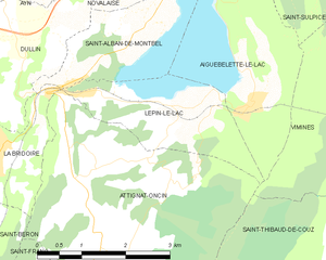
Lépin-le-Lac
- коммуна во Франции
Hiking in Lépin-le-Lac
Lépin-le-Lac, located in the idyllic Savoie region of the French Alps, offers an excellent opportunity for hiking enthusiasts seeking stunning landscapes and a mix of outdoor activities. Here’s a breakdown of what you can expect when hiking in this area:...
- Страна:
- Почтовый код: 73610
- Координаты: 45° 32' 7" N, 5° 47' 40" E
- GPS треки (wikiloc): [Ссылка]
- Площадь: 5.11 кв.км
- Население: 454