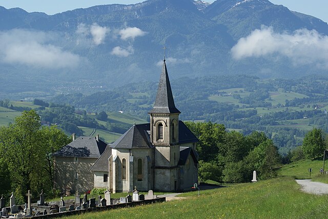
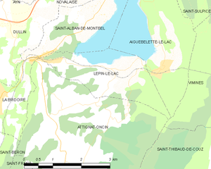
Attignat-Oncin (Attignat-Oncin)

- коммуна во Франции
 Hiking in Attignat-Oncin
Attignat-Oncin is a lovely commune in the Auvergne-Rhône-Alpes region of France, nestled at the foothills of the French Alps. It offers a range of hiking opportunities that cater to various skill levels, making it an ideal destination for nature lovers and outdoor enthusiasts.
Hiking Trails
The area is characterized by beautiful landscapes, including rolling hills, forests, and scenic views of the surrounding mountains. Here are some highlights:
-
Le Grand Huit: This scenic loop trail takes hikers through picturesque countryside, including vineyards and forests. It’s perfect for a half-day trip, providing moderate difficulty with well-marked paths.
-
Viarhôna: While not exclusively in Attignat-Oncin, the nearby Viarhôna cycling and walking route runs along the Rhône River and offers beautiful views and easy terrain, suitable for family hikes or leisurely walks.
-
Mont d'Or: A hike to Mont d'Or provides a more challenging experience with rewarding panoramic views from the top. The trail can be steep in sections, so it’s recommended for those with a bit more hiking experience.
-
Local Nature Trails: Many shorter paths and trails wind through the local forests. These trails are often less crowded and offer a peaceful way to enjoy the natural beauty of the area.
Tips for Hiking in Attignat-Oncin
- Seasonal Cautions: Always check trail conditions, especially in winter or early spring when there may still be snow or muddy paths.
- Navigation: Ensure you have a good map or GPS, as some trails can be poorly marked.
- Wildlife: Be aware of local wildlife and practice leave-no-trace principles.
- Hydration and Snacks: Always carry enough water and some snacks, especially on longer hikes.
Amenities
There are local accommodations, and dining options to help you refuel after a day of hiking. Consider packing a picnic to enjoy at one of the scenic viewpoints along the trails.
Overall, Attignat-Oncin is a fantastic base for hiking in the beautiful, natural landscapes of the French Alps, with options suitable for every hiker. Enjoy your adventure!
- Страна:

- Почтовый код: 73610
- Координаты: 45° 30' 30" N, 5° 46' 33" E


- GPS треки (wikiloc): [Ссылка]
- Площадь: 18.46 кв.км
- Население: 527
- Википедия английская: wiki(en)
- Википедия национальная: wiki(fr)
- Хранилище Wikidata: Wikidata: Q1231221
- Катеория в википедии: [Ссылка]
- код Freebase: [/m/03cb_t3]
- код GeoNames: Альт: [6450966]
- номер SIREN: [217300227]
- код BNF: [152739585]
- код муниципалитета INSEE: 73022
Граничит с регионами:


Saint-Thibaud-de-Couz
- коммуна во Франции
Hiking in Saint-Thibaud-de-Couz
Saint-Thibaud-de-Couz is a charming commune located in the Savoie department of the Auvergne-Rhône-Alpes region in southeastern France. It is surrounded by the breathtaking natural beauty of the Alps, making it an excellent destination for hiking enthusiasts. Here are some highlights to consider when planning a hiking adventure in and around Saint-Thibaud-de-Couz:...
- Страна:
- Почтовый код: 73160
- Координаты: 45° 30' 4" N, 5° 50' 40" E
- GPS треки (wikiloc): [Ссылка]
- Площадь: 24.17 кв.км
- Население: 1041


Vimines
- коммуна во Франции
Hiking in Vimines
It seems that Vimines might be a lesser-known location, as it doesn't appear in common hiking resources or databases. However, if you have a specific area in mind, such as a town or region near Vimines, I can offer general hiking advice or information on nearby hiking trails....
- Страна:
- Почтовый код: 73160
- Координаты: 45° 32' 44" N, 5° 51' 54" E
- GPS треки (wikiloc): [Ссылка]
- Площадь: 14.23 кв.км
- Население: 1965
- Веб сайт: [Ссылка]

Saint-Franc
- коммуна во Франции
Hiking in Saint-Franc
Saint-Franc, often referred to in the context of Saint-François, is a scenic region located in Guadeloupe, known for its beautiful landscapes and diverse hiking opportunities. When hiking in this area, you can expect a mix of coastal and inland trails offering stunning views, lush vegetation, and unique wildlife....
- Страна:
- Почтовый код: 73360
- Координаты: 45° 29' 29" N, 5° 44' 46" E
- GPS треки (wikiloc): [Ссылка]
- Площадь: 7.25 кв.км
- Население: 166


Saint-Béron
- коммуна во Франции
Hiking in Saint-Béron
Saint-Béron is a charming commune located in the Savoie department of the Auvergne-Rhône-Alpes region in southeastern France. It's nestled in the foothills of the French Alps, providing some beautiful hiking opportunities for outdoor enthusiasts....
- Страна:
- Почтовый код: 73520
- Координаты: 45° 30' 5" N, 5° 43' 45" E
- GPS треки (wikiloc): [Ссылка]
- Площадь: 8.66 кв.км
- Население: 1656


La Bridoire
- коммуна во Франции
Hiking in La Bridoire
La Bridoire is a charming commune located in the Savoie department of the Auvergne-Rhône-Alpes region in southeastern France. It is set in a scenic area that offers a variety of hiking opportunities amidst beautiful landscapes....
- Страна:
- Почтовый код: 73520
- Координаты: 45° 31' 34" N, 5° 44' 33" E
- GPS треки (wikiloc): [Ссылка]
- Площадь: 6.18 кв.км
- Население: 1238


La Bauche
- коммуна во Франции
Hiking in La Bauche
La Bauche, located in the Auvergne-Rhône-Alpes region of France, offers a variety of hiking opportunities that showcase the beautiful landscapes and unique geology of the area. While it may not be as well-known as some of the larger alpine areas, it has its own charm....
- Страна:
- Почтовый код: 73360
- Координаты: 45° 28' 57" N, 5° 45' 54" E
- GPS треки (wikiloc): [Ссылка]
- Площадь: 6.58 кв.км
- Население: 512

Lépin-le-Lac
- коммуна во Франции
Hiking in Lépin-le-Lac
Lépin-le-Lac, located in the idyllic Savoie region of the French Alps, offers an excellent opportunity for hiking enthusiasts seeking stunning landscapes and a mix of outdoor activities. Here’s a breakdown of what you can expect when hiking in this area:...
- Страна:
- Почтовый код: 73610
- Координаты: 45° 32' 7" N, 5° 47' 40" E
- GPS треки (wikiloc): [Ссылка]
- Площадь: 5.11 кв.км
- Население: 454