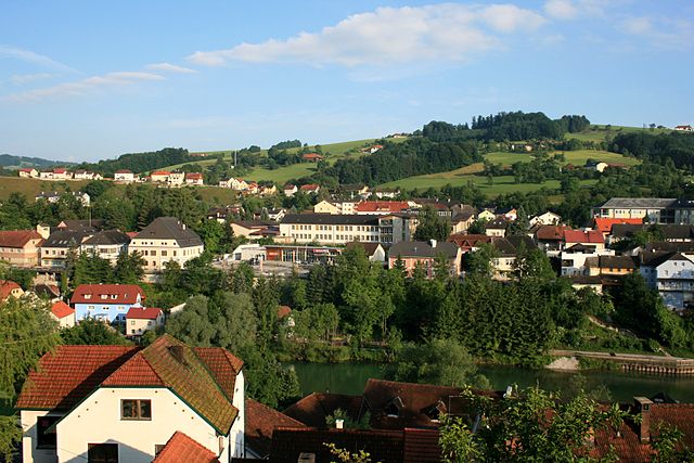
Вальднойкирхен (Waldneukirchen, Waldneukirchen)
- коммуна в федеральной земле Верхняя Австрия, Австрия
 Hiking in Вальднойкирхен
Waldneukirchen, a charming municipality in Austria, offers stunning landscapes that are ideal for hiking enthusiasts. Nestled in the hills and forests of Upper Austria, it features various trails that cater to different skill levels, making it a great destination for both beginners and experienced hikers.
Hiking Trails
-
Local Trails: Waldneukirchen is surrounded by numerous local trails that wind through lush forests, meadows, and scenic viewpoints. These trails often offer maps and marked paths.
-
Difficulty Levels: You can find easy, moderate, and challenging routes. Beginners may enjoy gentle paths in the surrounding woods, while experienced hikers can tackle steeper inclines with rewarding views of the surrounding countryside.
-
Nature Reserves: Nearby nature reserves provide opportunities to experience the local flora and fauna. Hiking in these areas allows you to enjoy tranquility and the beauty of nature.
-
Scenic Views: Many trails lead to vantage points where hikers can take in the picturesque landscapes of the region, including valleys, hills, and the scenic village itself.
Preparing for Your Hike
- Footwear: Make sure to wear suitable hiking boots for comfort and safety.
- Weather: Check the weather forecast before heading out, as conditions can change quickly in mountainous areas.
- Supplies: Carry enough water, snacks, and a first aid kit for longer hikes.
- Navigation: Bring a map or a GPS device, especially if you’re unfamiliar with the area.
Additional Outdoor Activities
Waldneukirchen offers more than just hiking. You can explore cycling routes, try horseback riding, or enjoy a picnic in one of the many serene spots.
Conclusion
Overall, hiking in Waldneukirchen provides a wonderful opportunity to connect with nature and enjoy the stunning landscapes of Upper Austria. Whether you're looking for a peaceful walk or a challenging trek, you'll find plenty of options to suit your preferences. Enjoy your adventure!
- Страна:

- Почтовый код: 4595
- Телефонный код: 07258
- Код автомобильного номера: SE
- Координаты: 47° 59' 49" N, 14° 15' 41" E


- GPS треки (wikiloc): [Ссылка]
- Высота над уровнем моря: 446 м m
- Площадь: 26 кв.км
- Население: 2242
- Веб сайт: http://www.waldneukirchen.at/
- Википедия русская: wiki(ru)
- Википедия английская: wiki(en)
- Википедия национальная: wiki(de)
- Хранилище Wikidata: Wikidata: Q667479
- Катеория в википедии: [Ссылка]
- код Freebase: [/m/03gvcdk]
- код GeoNames: Альт: [2761989]
- код VIAF: Альт: [236588387]
- код GND: Альт: [4837253-5]
- код австрийского муниципалитета: [41518]
Граничит с регионами:

Зирнинг
- ярмарочная коммуна в федеральной земле Верхняя Австрия, Австрия
Hiking in Зирнинг
Sierning, located in Austria, is not a well-known hiking destination, but it offers access to beautiful landscapes and trails suitable for outdoor enthusiasts. The surrounding areas, particularly in the Upper Austria region, provide a variety of hiking opportunities ranging from easy walks to more challenging routes....
- Страна:
- Телефонный код: 07259
- Код автомобильного номера: SE
- Координаты: 48° 2' 37" N, 14° 18' 30" E
- GPS треки (wikiloc): [Ссылка]
- Высота над уровнем моря: 367 м m
- Площадь: 38.2 кв.км
- Население: 9371
- Веб сайт: [Ссылка]

Бад-Халль
- город в федеральной земле Верхняя Австрия, Австрия
Hiking in Бад-Халль
Bad Hall, located in the Upper Austria region, is a charming town known for its spa facilities and beautiful natural landscapes. The surrounding area offers various hiking opportunities that showcase the scenic beauty of the region, including rolling hills, forests, and views of the nearby mountains....
- Страна:
- Почтовый код: 4540
- Телефонный код: 07258
- Код автомобильного номера: SE
- Координаты: 48° 2' 4" N, 14° 12' 35" E
- GPS треки (wikiloc): [Ссылка]
- Высота над уровнем моря: 380 м m
- Площадь: 13.38 кв.км
- Население: 5043
- Веб сайт: [Ссылка]

Адльванг
- коммуна в федеральной земле Верхняя Австрия, Австрия
Hiking in Адльванг
Adlwang is a scenic area located in Austria, particularly known for its beautiful landscapes and outdoor activities, including hiking. The region offers a variety of trails suitable for different skill levels, making it a great destination for both beginners and experienced hikers....
- Страна:
- Почтовый код: 4541
- Телефонный код: 07258
- Код автомобильного номера: SE
- Координаты: 47° 59' 31" N, 14° 13' 4" E
- GPS треки (wikiloc): [Ссылка]
- Высота над уровнем моря: 422 м m
- Площадь: 17 кв.км
- Население: 1806
- Веб сайт: [Ссылка]
Грюнбург
Hiking in Грюнбург
Grünburg, located in the scenic region of Upper Austria, is an excellent destination for hiking enthusiasts. It boasts beautiful natural landscapes, including lush forests, rolling hills, and stunning views of the surrounding mountains....
- Страна:
- Код автомобильного номера: KI
- Координаты: 47° 58' 19" N, 14° 16' 40" E
- GPS треки (wikiloc): [Ссылка]
- Высота над уровнем моря: 365 м m
- Площадь: 43.2 кв.км
- Население: 3840
- Веб сайт: [Ссылка]

Ашах-на-Штайре
- коммуна в федеральной земле Верхняя Австрия, Австрия
Hiking in Ашах-на-Штайре
Aschach an der Steyr is a picturesque town located in the Upper Austria region, and it’s a great starting point for hiking enthusiasts looking to explore the beautiful landscapes of the area. The region is characterized by its rolling hills, scenic valleys, and dense forests, making it ideal for a variety of hiking experiences....
- Страна:
- Почтовый код: 4421
- Телефонный код: 07259
- Код автомобильного номера: SE
- Координаты: 48° 0' 49" N, 14° 20' 1" E
- GPS треки (wikiloc): [Ссылка]
- Высота над уровнем моря: 435 м m
- Площадь: 22 кв.км
- Население: 2266
- Веб сайт: [Ссылка]

Штайнбах-на-Штайре
Hiking in Штайнбах-на-Штайре
Steinbach an der Steyr is a picturesque village situated in the Upper Austria region, known for its beautiful landscapes and access to outdoor activities, including hiking. The area is characterized by its stunning natural scenery, including rolling hills, the Steyr River, and lush forests, making it an ideal destination for hikers of all levels....
- Страна:
- Почтовый код: 4596
- Телефонный код: 07257
- Код автомобильного номера: KI
- Координаты: 47° 58' 16" N, 14° 16' 1" E
- GPS треки (wikiloc): [Ссылка]
- Высота над уровнем моря: 381 м m
- Площадь: 28.2 кв.км
- Население: 2009
- Веб сайт: [Ссылка]