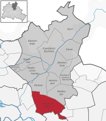
Вайсензе (Weissensee, Weißensee)

- район в Берлине
 Hiking in Вайсензе
Weissensee is a district in the northeastern part of Berlin, known for its large lake, Weissensee, which is a popular destination for both locals and tourists looking to enjoy nature and outdoor activities. While Weissensee is not traditionally associated with extensive hiking trails like some of the larger natural parks or forested areas, it offers some lovely spots for walking and enjoying the outdoors.
Here are some highlights for hiking or walking in Weissensee:
-
Weissensee Lake: The area around Weissensee Lake features a scenic route that circles the lake, approximately 2.5 kilometers (1.5 miles) in length. This path is accessible for walkers and joggers and offers beautiful views of the water, particularly in the warmer months when you can see people picnicking and swimming.
-
Parks and Green Spaces: In addition to the lake, Weissensee has several parks, such as Volkspark Weißensee, which provides plenty of green space for walking, relaxing, and enjoying nature. The park has well-maintained paths suitable for casual walking and offers a peaceful atmosphere.
-
Local Nature: The area around Weissensee features a mix of urban and natural landscapes. You can explore some smaller trails and paths through nearby residential areas and connecting parks. It's a great way to experience both the local culture and the outdoors.
-
Accessibility: Weissensee is well-connected by public transport, making it easy to access for hikers looking to explore the area. Public transport options include trams and buses that can take you to various starting points for your walks.
-
Wildlife Watching: Along the lake and within the parks, you might encounter a variety of bird species and other wildlife, particularly if you take the time to wander around the more natural areas.
While Weissensee might not offer extensive hiking trails akin to mountainous regions or forests, it provides a well-loved escape for walking, leisurely strolls, and enjoying the outdoors amidst an urban setting. For more extensive hiking options, consider exploring nearby nature reserves or parks outside the city. Always check local maps and guides for specific trails and conditions.
- Страна:

- Координаты: 52° 33' 0" N, 13° 28' 0" E


- GPS треки (wikiloc): [Ссылка]
- Высота над уровнем моря: 53 м m
- Площадь: 7.93 кв.км
- Население: 51699
- Веб сайт: http://www.weissensee.de/
- Википедия русская: wiki(ru)
- Википедия английская: wiki(en)
- Википедия национальная: wiki(de)
- Хранилище Wikidata: Wikidata: Q675164
- Галерея изображений в википедии: [Ссылка]
- Катеория в википедии: [Ссылка]
- Карты в википедии: [Ссылка]
- код Freebase: [/m/0bmpkm]
- код GeoNames: Альт: [2813187]
- код VIAF: Альт: [136200909]
- ID отношения в OpenStreetMap: [408308]
- код GND: Альт: [4431460-7]
- идентификатор местоположения ArchINFORM: [3618]
- код LCNAF: Альт: [n95015897]
Граничит с регионами:

Пренцлауэр-Берг
- район в Берлине
Hiking in Пренцлауэр-Берг
Prenzlauer Berg, a vibrant district in Berlin, is primarily known for its urban environment, charming architecture, and lively atmosphere rather than traditional hiking trails. However, there are plenty of opportunities for enjoyable walks and exploration in this area. Here are some aspects to consider if you're looking to hike or walk in Prenzlauer Berg:...
- Страна:
- Координаты: 52° 32' 3" N, 13° 25' 7" E
- GPS треки (wikiloc): [Ссылка]
- Высота над уровнем моря: 54 м m
- Площадь: 11 кв.км
- Население: 156910


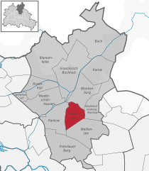
Панков
- район в одноимённом округе в Берлине
Hiking in Панков
Pankow is a district in northeastern Berlin, Germany, known for its charming neighborhoods, parks, and green areas. While it is more urban compared to rural hiking destinations, there are still opportunities for enjoyable walks and hikes within and around the area....
- Страна:
- Координаты: 52° 34' 0" N, 13° 24' 0" E
- GPS треки (wikiloc): [Ссылка]
- Высота над уровнем моря: 47 м m
- Площадь: 5.66 кв.км
- Население: 57113


Феннпфуль
- район в Берлине
Hiking in Феннпфуль
Fennpfuhl is a neighborhood in Berlin, Germany, known more for urban exploration than traditional hiking. However, if you're looking for green spaces or walking routes, there are some nearby parks and pathways that can provide a nice urban escape....
- Страна:
- Координаты: 52° 31' 42" N, 13° 28' 27" E
- GPS треки (wikiloc): [Ссылка]
- Высота над уровнем моря: 64 м m
- Площадь: 2.12 кв.км


Ной-Хоэншёнхаузен
- район в Берлине
Hiking in Ной-Хоэншёнхаузен
Neu-Hohenschönhausen is a district located in the northeastern part of Berlin, Germany. While it is primarily an urban area known for its residential neighborhoods, parks, and recreational spaces, there are still opportunities for hiking and enjoying nature nearby, particularly in green spaces and surrounding areas....
- Страна:
- Координаты: 52° 33' 48" N, 13° 30' 18" E
- GPS треки (wikiloc): [Ссылка]
- Высота над уровнем моря: 55 м m
- Площадь: 5.16 кв.км
- Население: 53374


Пригородный посёлок Мальхов
- район в Берлине
Hiking in Пригородный посёлок Мальхов
Stadtrandsiedlung Malchow is a charming area located in the outskirts of Berlin, characterized by its natural beauty and access to various outdoor activities, including hiking. Here’s a breakdown of what you can expect when hiking in this area:...
- Страна:
- Координаты: 52° 34' 20" N, 13° 28' 0" E
- GPS треки (wikiloc): [Ссылка]
- Высота над уровнем моря: 47 м m
- Площадь: 5.68 кв.км


Альт-Хоэншёнхаузен
- район в Берлине
Hiking in Альт-Хоэншёнхаузен
Alt-Hohenschönhausen, a district in the northeastern part of Berlin, Germany, may not be a traditional hiking destination, but it does offer some good opportunities for walking and exploring green spaces. Here are some points to consider if you're looking to hike or walk in this area:...
- Страна:
- Координаты: 52° 32' 55" N, 13° 30' 27" E
- GPS треки (wikiloc): [Ссылка]
- Высота над уровнем моря: 55 м m
- Площадь: 9.33 кв.км
- Население: 42609

Хайнерсдорф
- район в Берлине
Hiking in Хайнерсдорф
Heinersdorf, a charming district on the outskirts of Berlin, offers a unique opportunity for hiking enthusiasts to explore a blend of natural landscapes and quaint, urban settings. While Heinersdorf itself may not have extensive hiking trails like those found in more rugged areas, it serves as an excellent base for accessing nearby natural areas....
- Страна:
- Координаты: 52° 34' 1" N, 13° 26' 24" E
- GPS треки (wikiloc): [Ссылка]
- Высота над уровнем моря: 50 м m
- Площадь: 3.95 кв.км