Вайтерсфельд (Weitersfeld, Weitersfeld)
 Hiking in Вайтерсфельд
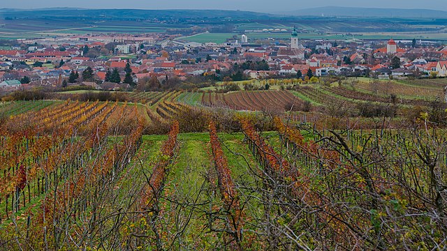
Weitersfeld, located in Lower Austria, is a picturesque area that offers a variety of hiking opportunities. The region is known for its beautiful landscapes, including rolling hills, forests, and vineyards. Here are some aspects to consider if you're planning to hike in Weitersfeld:
Hiking Trails
- Scenic Routes: The hiking trails typically feature scenic vistas of the surrounding countryside, with options for both leisurely walks and more challenging hikes.
- Marked Trails: Many trails are well-marked, making it easier for hikers to navigate. Look for designated hiking signs or maps at local tourism offices to help you plan your route.
- Nature Experiences: Hikers can often encounter a range of flora and fauna, making it an ideal spot for nature lovers. Birdwatching and photographing wildlife can be rewarding here.
Difficulty Levels
- Beginner-Friendly Paths: There are trails suitable for families and beginners, offering gentle slopes and shorter distances.
- Moderate to Challenging Routes: For experienced hikers, there are more demanding routes that provide a good workout and a chance to explore less-traveled paths.
Best Times to Hike
- Spring and Fall: These seasons are particularly beautiful for hiking due to mild weather and vibrant foliage. Spring blooms and autumn colors can enhance the hiking experience.
- Summer: Summer can get quite warm, so it’s wise to start hikes early in the day to avoid the heat.
Preparation Tips
- Proper Footwear: Invest in good hiking boots or shoes for comfort and support.
- Water and Snacks: Carry plenty of water and snacks, especially for longer hikes.
- Navigation Tools: Even with marked trails, it’s helpful to have a map, a compass, or a hiking app to help keep you on track.
Local Attractions
- Cultural Sites: After hiking, consider exploring local wineries or historical sites in the area. Weitersfeld is near wine regions, allowing for a unique post-hike experience.
- Accommodations: Check for local guesthouses or lodges if you're planning to stay longer and explore more trails.
Safety Considerations
- Always inform someone about your hiking plans, especially if you are venturing alone.
- Pay attention to weather forecasts, as conditions can change quickly in mountainous or rural areas.
Hiking in Weitersfeld can be a wonderful outdoor experience that combines physical activity with the chance to immerse yourself in nature and local culture. Enjoy your hiking adventure!
- Страна:

- Почтовый код: 2084
- Телефонный код: 02948
- Код автомобильного номера: HO
- Координаты: 48° 46' 56" N, 15° 48' 40" E


- GPS треки (wikiloc): [Ссылка]
- Высота над уровнем моря: 441 м m
- Площадь: 87.2 кв.км
- Население: 1576
- Веб сайт: http://www.weitersfeld.at
- Википедия русская: wiki(ru)
- Википедия английская: wiki(en)
- Википедия национальная: wiki(de)
- Хранилище Wikidata: Wikidata: Q661578
- Катеория в википедии: [Ссылка]
- код Freebase: [/m/02qx9h5]
- код GeoNames: Альт: [7871783]
- код VIAF: Альт: [243838996]
- код австрийского муниципалитета: [31129]
Граничит с регионами:
Рец
Hiking in Рец
Retz, located in the Lower Austria region, is a charming town known for its scenic landscapes, historical architecture, and outdoor recreational opportunities. Hiking around Retz offers a variety of trails that cater to different skill levels, making it a great destination for both novice and experienced hikers....
- Страна:
- Почтовый код: 2070
- Телефонный код: 02942
- Код автомобильного номера: HL
- Координаты: 48° 45' 22" N, 15° 57' 8" E
- GPS треки (wikiloc): [Ссылка]
- Высота над уровнем моря: 252 м m
- Площадь: 45.01 кв.км
- Население: 4249
- Веб сайт: [Ссылка]

Хардегг
Hiking in Хардегг
Hardegg, located in the picturesque region of Lower Austria, is known for its stunning landscapes and rich history. As a hiking destination, it offers a variety of trails that cater to different skill levels, making it a great spot for both casual walkers and serious hikers....
- Страна:
- Почтовый код: 2082
- Телефонный код: 0 29 48
- Код автомобильного номера: HL
- Координаты: 48° 51' 9" N, 15° 51' 32" E
- GPS треки (wikiloc): [Ссылка]
- Высота над уровнем моря: 309 м m
- Площадь: 93.28 кв.км
- Население: 1309
- Веб сайт: [Ссылка]

Герас
Hiking in Герас
Geras, located in the Waldviertel region of Austria, is surrounded by beautiful landscapes that offer a variety of hiking opportunities. The picturesque countryside, with its rolling hills, dense forests, and charming villages, provides an excellent backdrop for outdoor enthusiasts....
- Страна:
- Телефонный код: 02912
- Код автомобильного номера: HO
- Координаты: 48° 47' 56" N, 15° 40' 28" E
- GPS треки (wikiloc): [Ссылка]
- Высота над уровнем моря: 460 м m
- Площадь: 67.66 кв.км
- Население: 1325
- Веб сайт: [Ссылка]

Шраттенталь
Hiking in Шраттенталь
Schrattenthal, a picturesque village located in the wine region of Lower Austria, offers an array of hiking opportunities for adventurers and nature enthusiasts. The area is characterized by rolling hills, vineyards, and the stunning landscapes of the Weinviertel region....
- Страна:
- Почтовый код: 2073
- Телефонный код: 02942
- Код автомобильного номера: HL
- Координаты: 48° 43' 0" N, 15° 54' 0" E
- GPS треки (wikiloc): [Ссылка]
- Высота над уровнем моря: 289 м m
- Площадь: 22.43 кв.км
- Население: 868
- Веб сайт: [Ссылка]

Лангау
Hiking in Лангау
Langau is a small but beautiful area located in Austria, known for its stunning natural landscapes and outdoor activities, including hiking. Here are some key points to consider for hiking in Langau:...
- Страна:
- Почтовый код: 2091
- Телефонный код: 02912
- Код автомобильного номера: HO
- Координаты: 48° 49' 0" N, 15° 42' 0" E
- GPS треки (wikiloc): [Ссылка]
- Высота над уровнем моря: 450 м m
- Площадь: 22.21 кв.км
- Население: 673
- Веб сайт: [Ссылка]

Зигмундсхерберг
Hiking in Зигмундсхерберг
Sigmundsherberg is a picturesque area located in Lower Austria, known for its beautiful landscapes and hiking opportunities. It offers a variety of trails that cater to different skill levels, making it an excellent destination for both novice and experienced hikers....
- Страна:
- Почтовый код: 3751
- Телефонный код: 02983
- Код автомобильного номера: HO
- Координаты: 48° 41' 10" N, 15° 44' 47" E
- GPS треки (wikiloc): [Ссылка]
- Высота над уровнем моря: 429 м m
- Площадь: 47.95 кв.км
- Население: 1651
- Веб сайт: [Ссылка]