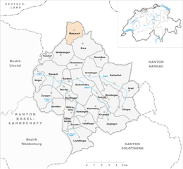
Винтерзинген (Wintersingen, Wintersingen)

 Hiking in Винтерзинген
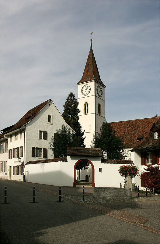
Wintersingen, located in the Swiss Canton of Basel-Landschaft, offers picturesque landscapes and a variety of hiking opportunities. The region is characterized by its rolling hills, vineyards, and dense forests, providing a serene backdrop for outdoor enthusiasts.
Popular Hiking Trails in Wintersingen
-
Weinwanderweg (Wine Trail): This trail takes you through vineyards and is perfect for wine lovers. You can enjoy beautiful views of the surrounding countryside and may even have the opportunity to stop at local wineries.
-
Nature Trails: Several nature trails wind through the forests around Wintersingen, showcasing the local flora and fauna. These paths are often well-marked and suitable for all skill levels.
-
Basel-Landschaft Hiking Network: Wintersingen is connected to a larger hiking network in the Basel-Landschaft region, allowing for extended hikes of varying difficulties. You can plan routes that suit your experience level, from easy walks to more strenuous hikes.
Tips for Hiking in Wintersingen
- Maps and Signage: Ensure you have a hiking map or a GPS device. The trails are generally well-marked, but having a backup is always a good idea.
- Local Weather: Check the weather conditions before you head out, as they can change rapidly in the region.
- Proper Gear: Wear suitable hiking shoes with good grip, and bring water, snacks, and sun protection, especially during warmer months.
- Respect Nature: Follow local guidelines to preserve the natural beauty of the area, including staying on marked paths and taking your trash with you.
Accessibility
Wintersingen is easily accessible by public transportation from nearby cities, which makes it convenient for day hikes. You can also find accommodations in nearby towns if you wish to extend your stay.
Overall, hiking in Wintersingen offers a wonderful opportunity to experience the natural beauty and tranquility of Switzerland, making it a fantastic choice for both beginner and experienced hikers.
- Страна:

- Почтовый код: 4451
- Телефонный код: 061
- Код автомобильного номера: BL
- Координаты: 47° 29' 45" N, 7° 49' 31" E


- GPS треки (wikiloc): [Ссылка]
- Высота над уровнем моря: 489 м m
- Площадь: 6.95 кв.км
- Население: 606
- Веб сайт: http://www.wintersingen.ch
- Википедия русская: wiki(ru)
- Википедия английская: wiki(en)
- Википедия национальная: wiki(de)
- Хранилище Wikidata: Wikidata: Q66111
- Катеория в википедии: [Ссылка]
- код Freebase: [/m/0g821z]
- код GeoNames: Альт: [7287591]
- код VIAF: Альт: [244719761]
- ID отношения в OpenStreetMap: [1683722]
- идентификатор HDS: [1241]
- код швейцарского муниципалитета: [2866]
Граничит с регионами:

Майспрах
Hiking in Майспрах
Maisprach is a small area located in the beautiful region of the Black Forest in Germany. While it may not be as well-known as some larger hiking destinations, it offers a tranquil and scenic experience for nature enthusiasts and hikers....
- Страна:
- Почтовый код: 4464
- Телефонный код: 061
- Код автомобильного номера: BL
- Координаты: 47° 31' 28" N, 7° 50' 45" E
- GPS треки (wikiloc): [Ссылка]
- Высота над уровнем моря: 379 м m
- Площадь: 5.06 кв.км
- Население: 939
- Веб сайт: [Ссылка]

Буус
Hiking in Буус
Buus is a charming village in the canton of Basel-Landschaft in Switzerland, known for its scenic landscapes and access to numerous hiking trails. The area around Buus offers a diverse range of hiking opportunities, suitable for all skill levels....
- Страна:
- Почтовый код: 4463
- Телефонный код: 061
- Код автомобильного номера: BL
- Координаты: 47° 30' 19" N, 7° 51' 52" E
- GPS треки (wikiloc): [Ссылка]
- Высота над уровнем моря: 449 м m
- Площадь: 8.85 кв.км
- Население: 1035
- Веб сайт: [Ссылка]
Нусхоф
Hiking in Нусхоф
Nusshof is not widely known as a major hiking destination, which may suggest it is a smaller or lesser-known area. However, if you are referring to a specific region or park named Nusshof, the hiking experiences can vary greatly depending on the terrain and local nature....
- Страна:
- Почтовый код: 4453
- Телефонный код: 061
- Код автомобильного номера: BL
- Координаты: 47° 29' 29" N, 7° 47' 55" E
- GPS треки (wikiloc): [Ссылка]
- Высота над уровнем моря: 519 м m
- Площадь: 1.97 кв.км
- Население: 255
- Веб сайт: [Ссылка]

Зиссах
Hiking in Зиссах
Sissach is a picturesque municipality located in the Baselland region of Switzerland, surrounded by beautiful landscapes and natural beauty, making it an excellent destination for hiking enthusiasts. Here’s what you should know about hiking in Sissach:...
- Страна:
- Почтовый код: 4450
- Телефонный код: 061
- Код автомобильного номера: BL
- Координаты: 47° 28' 0" N, 7° 49' 0" E
- GPS треки (wikiloc): [Ссылка]
- Высота над уровнем моря: 372 м m
- Площадь: 8.87 кв.км
- Население: 6666
- Веб сайт: [Ссылка]


Риккенбах
- община в Швейцарии, Базель-Ланд
Hiking in Риккенбах
Rickenbach, located in the Basel-Landschaft region of Switzerland, offers a range of scenic hiking opportunities. The area is characterized by lush green landscapes, rolling hills, and picturesque views, making it ideal for both casual walkers and serious hikers. Here are some key points to consider when hiking in Rickenbach:...
- Страна:
- Почтовый код: 4462
- Телефонный код: 061
- Код автомобильного номера: BL
- Координаты: 47° 29' 4" N, 7° 50' 57" E
- GPS треки (wikiloc): [Ссылка]
- Высота над уровнем моря: 466 м m
- Площадь: 2.90 кв.км
- Население: 594
- Веб сайт: [Ссылка]