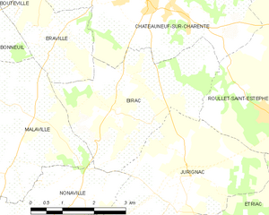
Éraville (Éraville)
- former commune in Charente, France
- Country:

- Postal Code: 16120
- Coordinates: 45° 34' 38" N, 0° 5' 31" E


- GPS tracks (wikiloc): [Link]
- Area: 5.47 sq km
- Population: 208
- Wikipedia en: wiki(en)
- Wikipedia: wiki(fr)
- Wikidata storage: Wikidata: Q43377
- Wikipedia Commons Category: [Link]
- Freebase ID: [/m/03mcb21]
- GeoNames ID: Alt: [3019948]
- INSEE municipality code: 16129
Shares border with regions:


Bonneuil
- commune in Charente, France
- Country:

- Postal Code: 16120
- Coordinates: 45° 34' 34" N, 0° 8' 25" E


- GPS tracks (wikiloc): [Link]
- Area: 13.58 sq km
- Population: 262


Birac
- commune in Charente, France
- Country:

- Postal Code: 16120
- Coordinates: 45° 33' 37" N, 0° 3' 47" E


- GPS tracks (wikiloc): [Link]
- Area: 11.84 sq km
- Population: 366


Malaville
- former commune in Charente, France
- Country:

- Postal Code: 16120
- Coordinates: 45° 33' 27" N, 0° 5' 49" E


- GPS tracks (wikiloc): [Link]
- Area: 12.82 sq km
- Population: 430


Bouteville
- commune in Charente, France
- Country:

- Postal Code: 16120
- Coordinates: 45° 35' 58" N, 0° 8' 11" E


- GPS tracks (wikiloc): [Link]
- Area: 12.07 sq km
- Population: 327


Châteauneuf-sur-Charente
- commune in Charente, France
- Country:

- Postal Code: 16120
- Coordinates: 45° 35' 55" N, 0° 3' 13" E


- GPS tracks (wikiloc): [Link]
- Area: 24.02 sq km
- Population: 3509
- Web site: [Link]
