Évriguet (Évriguet)

- commune in Morbihan, France
- Country:

- Postal Code: 56490
- Coordinates: 48° 4' 44" N, 2° 24' 41" E


- GPS tracks (wikiloc): [Link]
- Area: 4.98 sq km
- Population: 171
- Wikipedia en: wiki(en)
- Wikipedia: wiki(fr)
- Wikidata storage: Wikidata: Q128539
- Wikipedia Commons Category: [Link]
- Freebase ID: [/m/03c3w45]
- GeoNames ID: Alt: [6449852]
- SIREN number: [215600560]
- BnF ID: [15265306j]
- INSEE municipality code: 56056
Shares border with regions:


Saint-Brieuc-de-Mauron
- commune in Morbihan, France
- Country:
- Postal Code: 56430
- Coordinates: 48° 5' 23" N, 2° 21' 47" E
- GPS tracks (wikiloc): [Link]
- Area: 14.35 sq km
- Population: 344

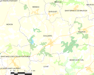
Guilliers
- commune in Morbihan, France
- Country:
- Postal Code: 56490
- Coordinates: 48° 2' 33" N, 2° 24' 20" E
- GPS tracks (wikiloc): [Link]
- Area: 35.14 sq km
- Population: 1342
- Web site: [Link]


Ménéac
- commune in Morbihan, France
- Country:
- Postal Code: 56490
- Coordinates: 48° 8' 22" N, 2° 27' 39" E
- GPS tracks (wikiloc): [Link]
- Area: 68.22 sq km
- Population: 1584
- Web site: [Link]

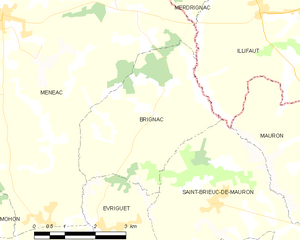
Brignac
- commune in Morbihan, France
- Country:
- Postal Code: 56430
- Coordinates: 48° 7' 14" N, 2° 23' 18" E
- GPS tracks (wikiloc): [Link]
- Area: 13.12 sq km
- Population: 181