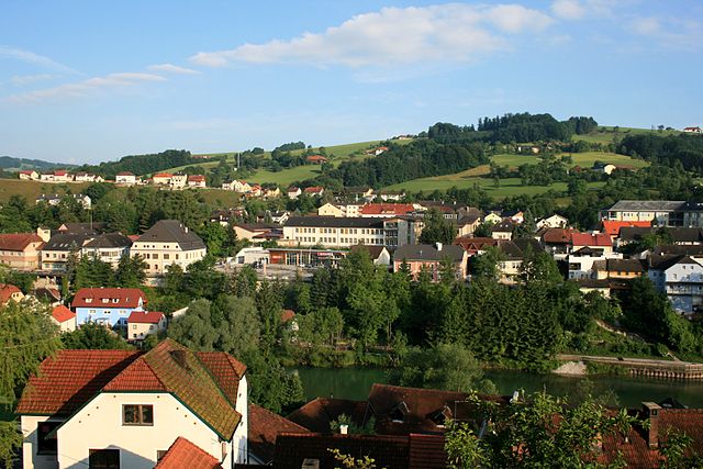
Adlwang (Adlwang)
- municipality in Austria
Adlwang is a scenic area located in Austria, particularly known for its beautiful landscapes and outdoor activities, including hiking. The region offers a variety of trails suitable for different skill levels, making it a great destination for both beginners and experienced hikers.
Hiking Trails
-
Nature Trails: Adlwang features several nature trails that let you explore the local flora and fauna. These trails often lead through dense forests, along rivers, and up to viewpoints where you can enjoy stunning panoramas.
-
Mountain Hikes: If you’re up for a more challenging adventure, there are mountainous trails that provide breathtaking views of the surrounding Alps. These hikes often require more preparation, so make sure to check the trail conditions and weather before you go.
-
Family-Friendly Options: Many trails are also suitable for families, with easier paths that allow kids to enjoy nature without strenuous terrain.
Tips for Hiking in Adlwang
- Wear Appropriate Gear: Good hiking boots, layered clothing, and weather-appropriate gear are essential. Always check the weather forecast before heading out.
- Stay Hydrated: Bring plenty of water, especially on longer hikes. There may not be access to clean water along the trails.
- Trail Maps and Navigation: While some trails may be well-marked, it’s always good to have a map or a GPS device to avoid getting lost.
- Respect Nature: Stick to marked trails to protect the local ecosystem. Carry out all trash and be mindful of wildlife.
Local Attractions
In addition to hiking, Adlwang may offer other outdoor activities such as cycling and fishing. Exploring nearby towns can also enhance your visit, providing opportunities to enjoy local cuisine and culture.
Conclusion
Hiking in Adlwang is a fantastic way to experience the natural beauty of Austria. With a variety of trails for all skill levels, it’s a destination worth exploring for outdoor enthusiasts. Always prepare adequately and take the time to enjoy the stunning landscapes around you!
- Country:

- Postal Code: 4541
- Local Dialing Code: 07258
- Licence Plate Code: SE
- Coordinates: 47° 59' 31" N, 14° 13' 4" E


- GPS tracks (wikiloc): [Link]
- AboveSeaLevel: 422 м m
- Area: 17 sq km
- Population: 1806
- Web site: http://www.adlwang.at
- Wikipedia en: wiki(en)
- Wikipedia: wiki(de)
- Wikidata storage: Wikidata: Q358645
- Wikipedia Commons Category: [Link]
- Freebase ID: [/m/03gvc38]
- GeoNames ID: Alt: [7873222]
- VIAF ID: Alt: [244310612]
- GND ID: Alt: [4798849-6]
- Austrian municipality key: [41501]
Shares border with regions:

Bad Hall
- municipality in Austria
Bad Hall, located in the Upper Austria region, is a charming town known for its spa facilities and beautiful natural landscapes. The surrounding area offers various hiking opportunities that showcase the scenic beauty of the region, including rolling hills, forests, and views of the nearby mountains....
- Country:

- Postal Code: 4540
- Local Dialing Code: 07258
- Licence Plate Code: SE
- Coordinates: 48° 2' 4" N, 14° 12' 35" E


- GPS tracks (wikiloc): [Link]
- AboveSeaLevel: 380 м m
- Area: 13.38 sq km
- Population: 5043
- Web site: [Link]

Pfarrkirchen bei Bad Hall
- municipality in Austria
 Hiking in Pfarrkirchen bei Bad Hall
Pfarrkirchen bei Bad Hall, located in Austria's Upper Austria region, is a charming area that offers beautiful hiking opportunities. The picturesque landscape, characterized by rolling hills, lush forests, and stunning views of the surrounding mountains, makes it an attractive destination for hikers of all levels....
- Country:

- Postal Code: 4540
- Local Dialing Code: 07258
- Licence Plate Code: SE
- Coordinates: 48° 1' 49" N, 14° 11' 58" E


- GPS tracks (wikiloc): [Link]
- AboveSeaLevel: 397 м m
- Area: 11 sq km
- Population: 2244
- Web site: [Link]

Waldneukirchen
- municipality in Austria
Waldneukirchen, a charming municipality in Austria, offers stunning landscapes that are ideal for hiking enthusiasts. Nestled in the hills and forests of Upper Austria, it features various trails that cater to different skill levels, making it a great destination for both beginners and experienced hikers....
- Country:

- Postal Code: 4595
- Local Dialing Code: 07258
- Licence Plate Code: SE
- Coordinates: 47° 59' 49" N, 14° 15' 41" E


- GPS tracks (wikiloc): [Link]
- AboveSeaLevel: 446 м m
- Area: 26 sq km
- Population: 2242
- Web site: [Link]

Grünburg
- municipality in Austria
Grünburg, located in the scenic region of Upper Austria, is an excellent destination for hiking enthusiasts. It boasts beautiful natural landscapes, including lush forests, rolling hills, and stunning views of the surrounding mountains....
- Country:

- Licence Plate Code: KI
- Coordinates: 47° 58' 19" N, 14° 16' 40" E


- GPS tracks (wikiloc): [Link]
- AboveSeaLevel: 365 м m
- Area: 43.2 sq km
- Population: 3840
- Web site: [Link]


Nußbach
- municipality in Austria
Nußbach, a small but scenic village in Austria, offers hiking opportunities that allow you to explore the beautiful landscapes of the region. Situated in Upper Austria, near the foothills of the Alps, the area is characterized by rolling hills, lush forests, and breathtaking mountain views....
- Country:

- Postal Code: 4542
- Local Dialing Code: 07587
- Licence Plate Code: KI
- Coordinates: 47° 58' 21" N, 14° 9' 53" E


- GPS tracks (wikiloc): [Link]
- AboveSeaLevel: 464 м m
- Area: 30.4 sq km
- Population: 2286
- Web site: [Link]