Alleyrat (Alleyrat)

- commune in Corrèze, France
- Country:

- Postal Code: 19200
- Coordinates: 45° 34' 37" N, 2° 12' 53" E


- GPS tracks (wikiloc): [Link]
- Area: 14.76 sq km
- Population: 91
- Wikipedia en: wiki(en)
- Wikipedia: wiki(fr)
- Wikidata storage: Wikidata: Q471630
- Wikipedia Commons Category: [Link]
- Freebase ID: [/m/03md42t]
- GeoNames ID: Alt: [6616043]
- SIREN number: [211900600]
- BnF ID: [15249642s]
- INSEE municipality code: 19006
Shares border with regions:


Chaveroche
- commune in Corrèze, France
- Country:
- Postal Code: 19200
- Coordinates: 45° 34' 27" N, 2° 15' 26" E
- GPS tracks (wikiloc): [Link]
- Area: 18.26 sq km
- Population: 204

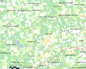
Meymac
- commune in Corrèze, France
- Country:
- Postal Code: 19250
- Coordinates: 45° 32' 9" N, 2° 8' 49" E
- GPS tracks (wikiloc): [Link]
- Area: 87.15 sq km
- Population: 2455


Saint-Germain-Lavolps
- commune in Corrèze, France
- Country:
- Postal Code: 19290
- Coordinates: 45° 36' 48" N, 2° 12' 21" E
- GPS tracks (wikiloc): [Link]
- Area: 21.89 sq km
- Population: 87

Saint-Angel
- commune in Corrèze, France
- Country:
- Postal Code: 19200
- Coordinates: 45° 30' 13" N, 2° 13' 54" E
- GPS tracks (wikiloc): [Link]
- Area: 47.54 sq km
- Population: 707
- Web site: [Link]