Allonnes, Sarthe (Allonnes)

- commune in Sarthe, France
- Country:

- Postal Code: 72700
- Coordinates: 47° 58' 7" N, 0° 9' 38" E


- GPS tracks (wikiloc): [Link]
- AboveSeaLevel: 53 м m
- Area: 18.07 sq km
- Population: 11128
- Web site: http://allonnes.fr
- Wikipedia en: wiki(en)
- Wikipedia: wiki(fr)
- Wikidata storage: Wikidata: Q478148
- Wikipedia Commons Category: [Link]
- Freebase ID: [/m/03qk1h0]
- GeoNames ID: Alt: [6614045]
- SIREN number: [217200039]
- BnF ID: [15273563n]
- GND ID: Alt: [4760742-7]
- MusicBrainz area ID: [c49ab53f-bfbb-4524-b0e0-44cbd8a94287]
- INSEE municipality code: 72003
Shares border with regions:

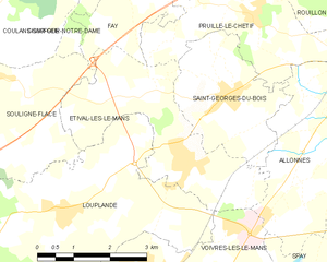
Étival-lès-le-Mans
- commune in Sarthe, France
- Country:
- Postal Code: 72700
- Coordinates: 47° 57' 23" N, 0° 5' 22" E
- GPS tracks (wikiloc): [Link]
- Area: 10.34 sq km
- Population: 1953
- Web site: [Link]


Saint-Georges-du-Bois
- commune in Sarthe, France
- Country:
- Postal Code: 72700
- Coordinates: 47° 58' 23" N, 0° 6' 0" E
- GPS tracks (wikiloc): [Link]
- Area: 7.23 sq km
- Population: 2078
- Web site: [Link]


Voivres-lès-le-Mans
- commune in Sarthe, France
- Country:
- Postal Code: 72210
- Coordinates: 47° 55' 47" N, 0° 4' 20" E
- GPS tracks (wikiloc): [Link]
- Area: 11.44 sq km
- Population: 1379

Le Mans
- commune in Sarthe, France
- Country:
- Postal Code: 72100; 72000
- Coordinates: 48° 0' 15" N, 0° 11' 49" E
- GPS tracks (wikiloc): [Link]
- AboveSeaLevel: 51 м m
- Area: 52.81 sq km
- Population: 143325
- Web site: [Link]

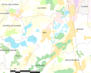
Spay, Sarthe
- commune in Sarthe, France
- Country:
- Postal Code: 72700
- Coordinates: 47° 55' 24" N, 0° 9' 3" E
- GPS tracks (wikiloc): [Link]
- Area: 14.22 sq km
- Population: 2898
- Web site: [Link]


Pruillé-le-Chétif
- commune in Sarthe, France
- Country:
- Postal Code: 72700
- Coordinates: 47° 59' 34" N, 0° 6' 31" E
- GPS tracks (wikiloc): [Link]
- Area: 10.3 sq km
- Population: 1322
- Web site: [Link]


Arnage
- commune in Sarthe, France
- Country:
- Postal Code: 72230
- Coordinates: 47° 55' 34" N, 0° 11' 16" E
- GPS tracks (wikiloc): [Link]
- Area: 10.76 sq km
- Population: 5191
- Web site: [Link]


Rouillon
- commune in Sarthe, France
- Country:
- Postal Code: 72700
- Coordinates: 48° 0' 27" N, 0° 8' 10" E
- GPS tracks (wikiloc): [Link]
- Area: 9.15 sq km
- Population: 2304
- Web site: [Link]