Allonzier-la-Caille (Allonzier-la-Caille)

- commune in Haute-Savoie, France
 Hiking in Allonzier-la-Caille
Allonzier-la-Caille is a beautiful commune located in the Haute-Savoie department in the Auvergne-Rhône-Alpes region of southeastern France. Nestled amid stunning natural landscapes, it offers various hiking opportunities suitable for different skill levels.
Hiking Trails and Areas
-
Local Trails: The area surrounding Allonzier-la-Caille features a variety of local trails that meander through forests, fields, and hills. These trails often provide pleasant views of the surrounding mountains and valleys.
-
Nearby Parks: The proximity to the natural parks of the region, such as the Regional Natural Park of Massif des Bauges, offers more extensive hiking routes that showcase the region's rich biodiversity and stunning views.
-
Elevated Trails: For those looking for elevation, consider trekking up to nearby peaks, where you can enjoy panoramic views of the Alps and Lake Annecy. Several trails in the region are well-marked and cater to both beginners and experienced hikers.
Hiking Tips
-
Season: Spring and early autumn are ideal times for hiking in this area to enjoy mild weather and beautiful landscapes. Winter months may offer opportunities for snowshoeing in the surrounding mountains.
-
Equipment: Good hiking boots and weather-appropriate clothing are essential, especially considering that temperatures can vary significantly in mountainous areas. Trekking poles can also be beneficial on steeper trails.
-
Safety: Always carry a map or GPS device and ensure someone knows your hiking itinerary. It's vital to stay hydrated and bring snacks for energy.
-
Local Flora and Fauna: The region is home to diverse wildlife and beautiful flora. Remember to respect the natural environment and stick to marked trails.
Additional Activities
In addition to hiking, the area offers opportunities for cycling, picnicking, and exploring the charming village of Allonzier-la-Caille itself, where you can enjoy local cuisine and culture.
Whether you're a seasoned hiker or just looking for a leisurely walk in nature, Allonzier-la-Caille provides an excellent setting for outdoor enthusiasts.
- Country:

- Postal Code: 74350
- Coordinates: 46° 0' 12" N, 6° 7' 0" E


- GPS tracks (wikiloc): [Link]
- Area: 9.62 sq km
- Population: 1944
- Web site: http://www.allonzierlacaille.fr
- Wikipedia en: wiki(en)
- Wikipedia: wiki(fr)
- Wikidata storage: Wikidata: Q829396
- Wikipedia Commons Category: [Link]
- Freebase ID: [/m/03ntxdc]
- GeoNames ID: Alt: [3038080]
- SIREN number: [217400068]
- BnF ID: [152742663]
- Pleiades ID: [167635]
- INSEE municipality code: 74006
Shares border with regions:

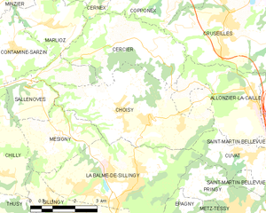
Choisy, Haute-Savoie
- commune in Haute-Savoie, France
Hiking in Choisy, Haute-Savoie
Choisy, located in the Haute-Savoie department in the Auvergne-Rhône-Alpes region of France, offers stunning hiking opportunities amid the picturesque landscapes of the French Alps. Here are some highlights and tips for hiking in Choisy:...
- Country:
- Postal Code: 74330
- Coordinates: 45° 59' 34" N, 6° 3' 27" E
- GPS tracks (wikiloc): [Link]
- Area: 16.57 sq km
- Population: 1558
- Web site: [Link]


Villy-le-Pelloux
- commune in Haute-Savoie, France
Hiking in Villy-le-Pelloux
Villy-le-Pelloux is a charming village located in the Haute-Savoie region of France, near the city of Annecy. The area is known for its breathtaking mountain scenery, lush forests, and a range of outdoor activities, making it a great spot for hiking enthusiasts....
- Country:
- Postal Code: 74350
- Coordinates: 46° 0' 1" N, 6° 7' 59" E
- GPS tracks (wikiloc): [Link]
- Area: 2.97 sq km
- Population: 922
- Web site: [Link]

Cercier
- commune in Haute-Savoie, France
Hiking in Cercier
Cercier, located in the scenic region of France, offers a variety of hiking opportunities that cater to different skill levels and preferences. The area is known for its beautiful landscapes, which include rolling hills, lush forests, and picturesque valleys. Here are some key points to consider when hiking in Cercier:...
- Country:
- Postal Code: 74350
- Coordinates: 46° 1' 31" N, 6° 2' 54" E
- GPS tracks (wikiloc): [Link]
- Area: 11.46 sq km
- Population: 655
- Web site: [Link]


Cuvat
- commune in Haute-Savoie, France
Hiking in Cuvat
Cuvat is not widely recognized as a prominent hiking destination, as it might be a less-known locale or a misspelling of a more popular region. However, if you are referring to a specific area or a different name, please provide more context....
- Country:
- Postal Code: 74350
- Coordinates: 45° 58' 39" N, 6° 7' 8" E
- GPS tracks (wikiloc): [Link]
- Area: 4.72 sq km
- Population: 1213
- Web site: [Link]


Cruseilles
- commune in Haute-Savoie, France
Hiking in Cruseilles
Cruseilles, located in the Auvergne-Rhône-Alpes region of France, offers scenic hiking opportunities with stunning views of the surrounding countryside and the nearby mountains, including the Saleve and the Bornes mountains. Here are some key points about hiking in Cruseilles:...
- Country:
- Postal Code: 74350
- Coordinates: 46° 2' 3" N, 6° 6' 27" E
- GPS tracks (wikiloc): [Link]
- Area: 25.41 sq km
- Population: 4326
- Web site: [Link]


Saint-Martin-Bellevue
- former commune in Haute-Savoie, France
Hiking in Saint-Martin-Bellevue
Saint-Martin-Bellevue is a charming commune located in the Haute-Savoie department in the Auvergne-Rhône-Alpes region of southeastern France. It is nestled near the foothills of the Alps, making it an excellent starting point for various hiking adventures. Here’s what you can expect when hiking in and around this picturesque area:...
- Country:
- Postal Code: 74370
- Coordinates: 45° 57' 44" N, 6° 8' 55" E
- GPS tracks (wikiloc): [Link]
- Area: 9.33 sq km
- Population: 2646
- Web site: [Link]