Angeac-Champagne (Angeac-Champagne)

- commune in Charente, France
- Country:

- Postal Code: 16130
- Coordinates: 45° 36' 27" N, 0° 17' 51" E


- GPS tracks (wikiloc): [Link]
- Area: 14.27 sq km
- Population: 509
- Web site: http://16012.campagnol.fr
- Wikipedia en: wiki(en)
- Wikipedia: wiki(fr)
- Wikidata storage: Wikidata: Q531031
- Wikipedia Commons Category: [Link]
- Freebase ID: [/m/03mbc4m]
- GeoNames ID: Alt: [3037667]
- SIREN number: [211600127]
- BnF ID: [15248451z]
- INSEE municipality code: 16012
Shares border with regions:

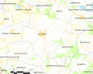
Segonzac
- commune in Charente, France
- Country:
- Postal Code: 16130
- Coordinates: 45° 37' 2" N, 0° 13' 8" E
- GPS tracks (wikiloc): [Link]
- Area: 35.19 sq km
- Population: 2107
- Web site: [Link]

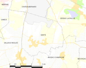
Genté
- commune in Charente, France
- Country:
- Postal Code: 16130
- Coordinates: 45° 37' 40" N, 0° 18' 50" E
- GPS tracks (wikiloc): [Link]
- Area: 11.59 sq km
- Population: 901
- Web site: [Link]


Gensac-la-Pallue
- commune in Charente, France
- Country:
- Postal Code: 16130
- Coordinates: 45° 39' 3" N, 0° 15' 10" E
- GPS tracks (wikiloc): [Link]
- Area: 19.23 sq km
- Population: 1594
- Web site: [Link]

Salles-d'Angles
- commune in Charente, France
- Country:
- Postal Code: 16130
- Coordinates: 45° 37' 5" N, 0° 20' 0" E
- GPS tracks (wikiloc): [Link]
- Area: 21.8 sq km
- Population: 1036


Juillac-le-Coq
- commune in Charente, France
- Country:
- Postal Code: 16130
- Coordinates: 45° 35' 0" N, 0° 16' 0" E
- GPS tracks (wikiloc): [Link]
- Area: 14.54 sq km
- Population: 652

Saint-Fort-sur-le-Né
- commune in Charente, France
- Country:
- Postal Code: 16130
- Coordinates: 45° 34' 38" N, 0° 18' 19" E
- GPS tracks (wikiloc): [Link]
- Area: 6.8 sq km
- Population: 371