Appeville-Annebault (Appeville-Annebault)

- commune in Eure, France
- Country:

- Postal Code: 27290
- Coordinates: 49° 19' 48" N, 0° 38' 32" E


- GPS tracks (wikiloc): [Link]
- Area: 13.35 sq km
- Population: 1017
- Wikipedia en: wiki(en)
- Wikipedia: wiki(fr)
- Wikidata storage: Wikidata: Q1009569
- Wikipedia Commons Category: [Link]
- Freebase ID: [/m/02x6c9x]
- Freebase ID: [/m/02x6c9x]
- GeoNames ID: Alt: [6447932]
- GeoNames ID: Alt: [6447932]
- SIREN number: [212700181]
- SIREN number: [212700181]
- BnF ID: [15253260c]
- BnF ID: [15253260c]
- PACTOLS thesaurus ID: [pcrt8R7Xmf5QkU]
- PACTOLS thesaurus ID: [pcrt8R7Xmf5QkU]
- INSEE municipality code: 27018
- INSEE municipality code: 27018
Shares border with regions:

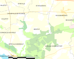
Brestot
- commune in Eure, France
- Country:
- Postal Code: 27350
- Coordinates: 49° 21' 6" N, 0° 41' 7" E
- GPS tracks (wikiloc): [Link]
- Area: 8.73 sq km
- Population: 553


Cauverville-en-Roumois
- commune in Eure, France
- Country:
- Postal Code: 27350
- Coordinates: 49° 21' 3" N, 0° 38' 47" E
- GPS tracks (wikiloc): [Link]
- Area: 3.24 sq km
- Population: 243

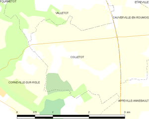
Colletot
- commune in Eure, France
- Country:
- Postal Code: 27500
- Coordinates: 49° 21' 1" N, 0° 37' 8" E
- GPS tracks (wikiloc): [Link]
- Area: 4.32 sq km
- Population: 199

Condé-sur-Risle
- commune in Eure, France
- Country:
- Postal Code: 27290
- Coordinates: 49° 18' 49" N, 0° 36' 59" E
- GPS tracks (wikiloc): [Link]
- Area: 9.87 sq km
- Population: 633
Corneville-sur-Risle
- commune in Eure, France
- Country:
- Postal Code: 27500
- Coordinates: 49° 20' 13" N, 0° 35' 39" E
- GPS tracks (wikiloc): [Link]
- Area: 13.23 sq km
- Population: 1334


Montfort-sur-Risle
- commune in Eure, France
- Country:
- Postal Code: 27290
- Coordinates: 49° 17' 43" N, 0° 39' 52" E
- GPS tracks (wikiloc): [Link]
- Area: 3.94 sq km
- Population: 750


Illeville-sur-Montfort
- commune in Eure, France
- Country:
- Postal Code: 27290
- Coordinates: 49° 19' 35" N, 0° 43' 36" E
- GPS tracks (wikiloc): [Link]
- Area: 14.95 sq km
- Population: 880