Argœuves (Argœuves)

- commune in Somme, France
- Country:

- Postal Code: 80470
- Coordinates: 49° 55' 49" N, 2° 13' 36" E


- GPS tracks (wikiloc): [Link]
- Area: 10.21 sq km
- Population: 549
- Web site: http://www.mairie-argoeuves.net/
- Wikipedia en: wiki(en)
- Wikipedia: wiki(fr)
- Wikidata storage: Wikidata: Q30749
- Wikipedia Commons Category: [Link]
- Freebase ID: [/m/03h11r2]
- GeoNames ID: Alt: [6614454]
- SIREN number: [218000222]
- PACTOLS thesaurus ID: [pcrtuohwGjSn4n]
- INSEE municipality code: 80024
Shares border with regions:

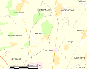
Bertangles
- commune in Somme, France
- Country:
- Postal Code: 80260
- Coordinates: 49° 58' 13" N, 2° 17' 59" E
- GPS tracks (wikiloc): [Link]
- Area: 8.57 sq km
- Population: 569
- Web site: [Link]


Amiens
- commune in Somme, France
- Country:
- Postal Code: 80000
- Coordinates: 49° 53' 31" N, 2° 17' 52" E
- GPS tracks (wikiloc): [Link]
- AboveSeaLevel: 106 м m
- Area: 49.46 sq km
- Population: 132874
- Web site: [Link]

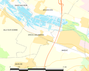
Dreuil-lès-Amiens
- commune in Somme, France
- Country:
- Postal Code: 80730
- Coordinates: 49° 54' 55" N, 2° 13' 46" E
- GPS tracks (wikiloc): [Link]
- Area: 3.18 sq km
- Population: 1578
- Web site: [Link]


Vaux-en-Amiénois
- commune in Somme, France
- Country:
- Postal Code: 80260
- Coordinates: 49° 57' 44" N, 2° 14' 54" E
- GPS tracks (wikiloc): [Link]
- Area: 11.18 sq km
- Population: 413

Saint-Sauveur
- commune in Somme, France
- Country:
- Postal Code: 80470
- Coordinates: 49° 56' 15" N, 2° 12' 39" E
- GPS tracks (wikiloc): [Link]
- Area: 9.04 sq km
- Population: 1421